


North and Central Texas
Scattered storms may develop during the day ahead of an approaching cold front. Some of these storms could become severe. However, the main event still appears to be a linear complex of storms along the rapidly advancing front. Damaging wind gusts, tornadoes, and large hail are all possible hazards tomorrow afternoon and evening. This line of storms will push east, impacting East Texas during the evening hours when the most significant threat for severe weather will occur. Stay weather aware and have multiple, reliable methods to receive warnings on Thursday. Know where to shelter before a warning is issued!
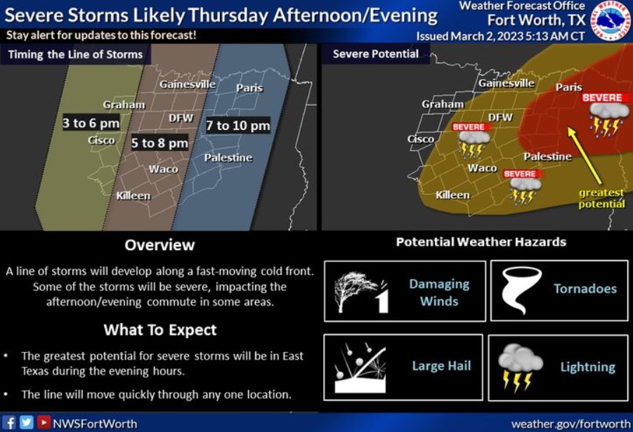
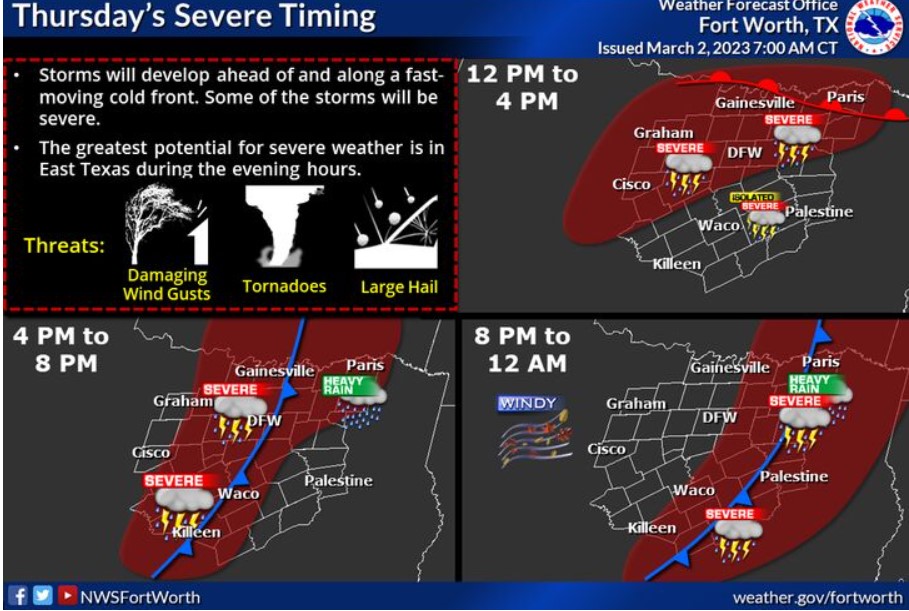
Scattered storms may develop during the day Thursday, ahead of an approaching cold front. Some of these storms could become severe. However, the main event still appears to be a linear complex of storms along the rapidly advancing front. Damaging wind gusts, tornadoes, and large hail are all possible hazards Thursday afternoon and evening. This line of storms will push east, impacting East Texas during the evening hours when the most significant threat for severe weather will occur. Stay weather aware and have multiple, reliable methods to receive warnings on Thursday. Know where to shelter before a warning is issued!

Know where to go before they issue a warning for your area! Move to an interior room on the lowest floor of your home, and stay away from windows. Leave mobile homes before a severe weather event begins to shelter with friends or family in a permanent building. If you’re driving when a warning is issued, NEVER stop under bridges or overpasses! It puts you at a greater risk of serious injury from flying debris! Instead, get off the road. The best option is to drive to a designated shelter, basement, or safe room.
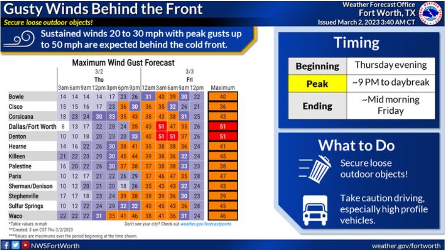
Sustained winds of 20 to 30 mph with gusts to around 50 mph are expected tonight behind the front and will continue into Friday morning. Secure loose outdoor objects and take caution driving high-profile vehicles.
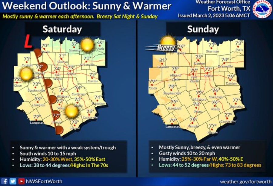
After a stormy end to the week, your weekend looks quiet, breezy, warm, and dry. Humidity will be low, with highs on Saturday in the 70s and between the mid-70s and lower 80s on Sunday. Southerly winds at 10 to 15 mph each will become gusty Saturday night and Sunday. Lows will be primarily in the mid-40s Saturday morning to the mid-40s and lower 50s Sunday morning.
Today and Tonight
Isolated to scattered thunderstorms are expected this morning along
and south of a stalled frontal boundary extending along a line from Sulphur Springs, Ennis, Hillsboro, and Comanche. Stronger storms may contain small hail, gusty outflow winds, and brief heavy rainfall are possible.
Thunderstorms will become more numerous by this afternoon and
continue into tonight, with widespread severe weather likely across
much of the region. The most significant risk for severe weather will exist
along and east of Highway 281 during the day, shifting east of the
I-35 corridor during the evening hours. All modes of severe weather
will be possible, including large hail, damaging wind gusts, and
tornadoes.
Windy conditions are expected overnight with gusts to near 45 mph
expected to arrive overnight.
Friday through Wednesday
Windy conditions will continue on Friday, especially during the
morning hours with gusts between 35 and 45 mph possible.
Thunderstorm chances return by the middle of next week, with the arrival of a strong cold front and upper-level disturbance.
SPOTTER INFORMATION STATEMENT
Spotter activation is likely this afternoon and evening, possibly
extending into the overnight hours north of Interstate 20.
South Central and Southwest Arkansas, North Central and Northwest Louisiana, Southeast Oklahoma, and East and Northeast Texas
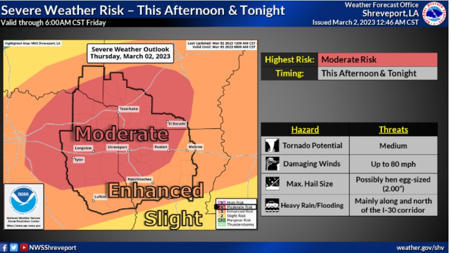
A Moderate Risk of severe weather is highlighted across much of the region, with an Enhanced Risk for the remainder of the area on Thursday afternoon through Thursday night. All modes of severe weather will be possible with potentially high-end threats in play. Stay tuned for the latest forecast information, and remember, now is the time to prepare!
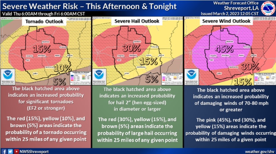
Severe weather is likely across the entire region Thursday afternoon, continuing into the overnight hours. The above graphic shows the different tornado, severe hail, and severe wind outlooks. Areas in the significant hatched area have the best chances to see strong EF2 or more significant tornadoes, damaging winds of 70-80 mph, and hail 2″ in diameter or greater.
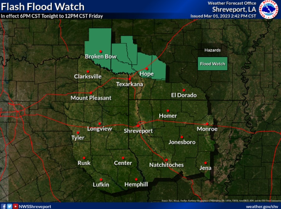
Areas of prolonged rainfall may result in flooding and flash flooding over the next few days. Therefore, a Flash Flood Watch is in effect through noon Friday.
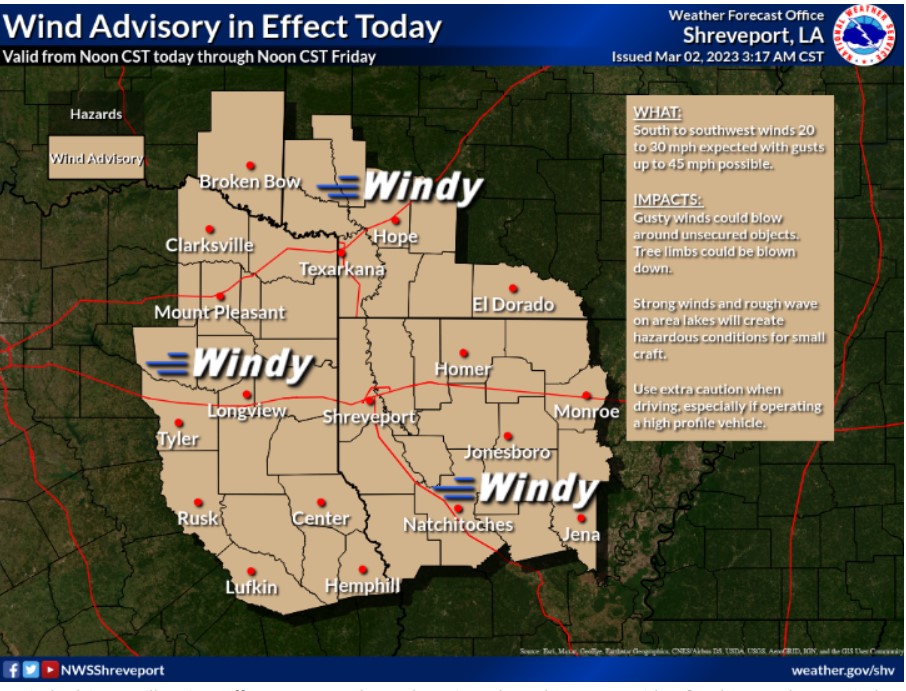
A Wind Advisory will go into effect at noon today and continue through noon on Friday. South to southwest winds of 20 to 30 mph are expected, with gusts up to 45 mph possible.
Thursday through Tuesday.
A widespread severe weather outbreak appears possible this afternoon and into Thursday night. There will be two chances for severe weather during the day. The first will come during the early or mid-afternoon hours when we have the potential for some discrete supercells ahead of the main line that will move through later in the day. The main threats for any discrete cells during the mid-afternoon would be large hail and the potential for strong tornadoes. Later in the afternoon and into the evening and overnight hours, as a cold front sweeps through the area, a line of thunderstorms will move through the region, bringing an additional threat of damaging winds of 70 to 80 mph possible and embedded tornadoes. Additionally,
moderate to heavy rainfall will bring the potential for isolated flash flooding across the northern portion of the area, where some locations could see a short 2 inches or more of rain.
SPOTTER INFORMATION STATEMENT
Expect spotter activation later today.