


North and Central Texas
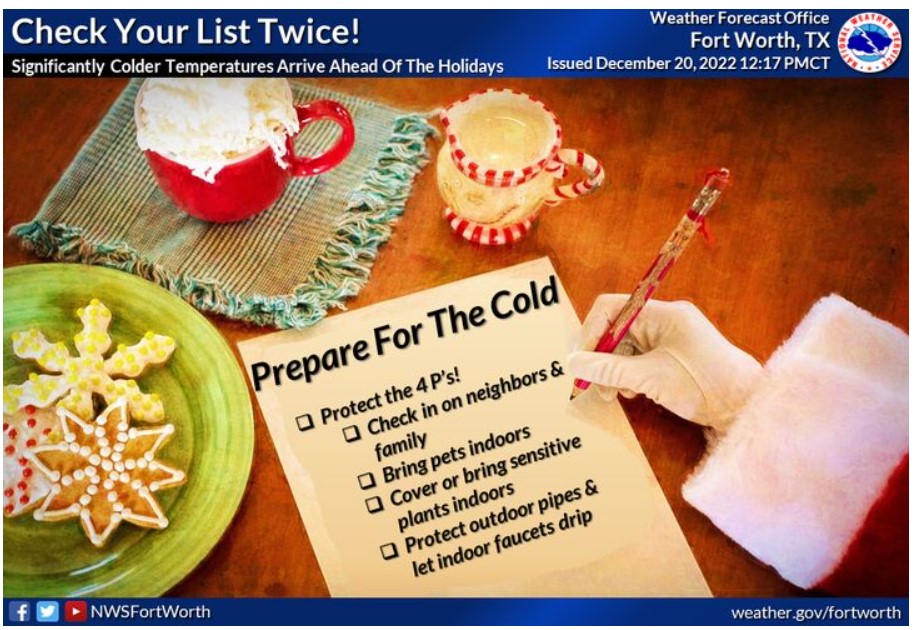
Make your list and check it twice! With significantly colder temperatures coming up late this week and the Holiday weekend, remember the four Ps! Check up on friends and family, bring in those furry pets, bring in vulnerable plants, and cover outdoor pipes and drip faucets to protect them from damage!
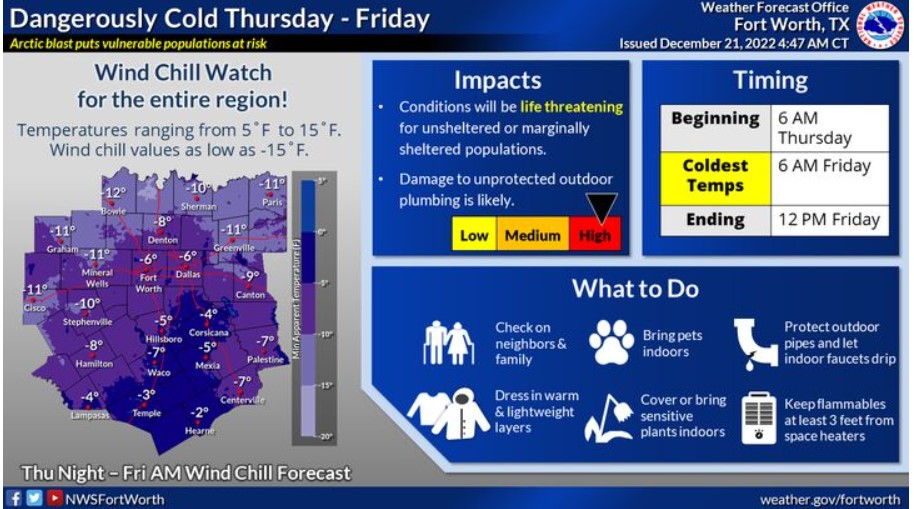
A Wind Chill Watch is in effect from Thursday through Friday for all our North and Central Texas counties. Frigid ambient temperatures and strong winds will allow dangerously cold wind chills as low as -15 degrees. These wind chills could result in hypothermia if you don’t take precautions. Make sure to avoid extended time outdoors if possible, and if you have to brave the cold, then dress in warm, lightweight layers and cover exposed skin. Bring pets and sensitive outdoor plants indoors, and protect outdoor pipes and faucets.
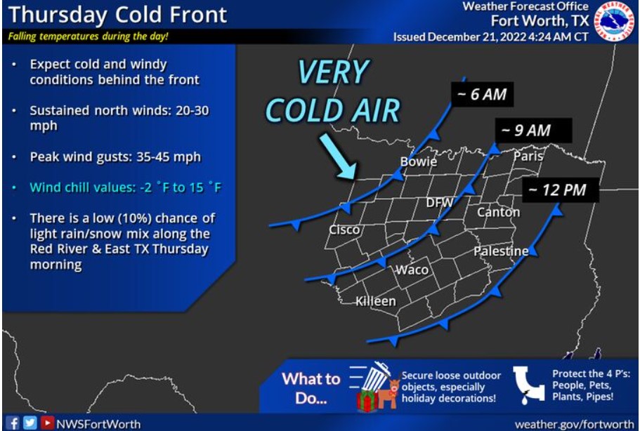
A strong cold front will blast through the region Thursday morning, leaving behind solid and gusty winds and sharply dropping temperatures. The cold front should exit the area around noon. With these wind speeds, secure any outdoor items and Christmas decorations!
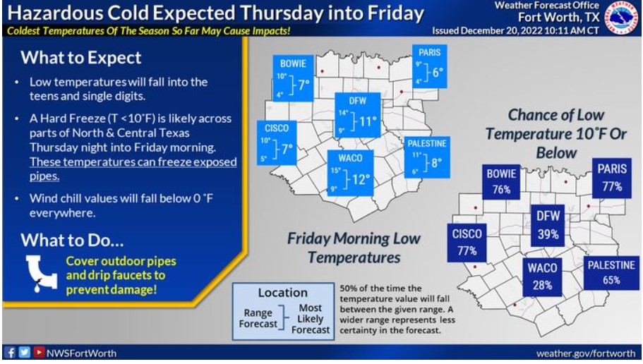
Low temperatures will fall into the teens and single digits Thursday night. A hard freeze, with temperatures less than or equal to 10F, is likely across North and Central Texas. Wind chill values will fall below 0F across the region. These temperatures can freeze exposed pipes, so remember to cover outdoor lines and let faucets drip! Take the necessary actions to protect the four P’s: people, pets, plants, and pipes!
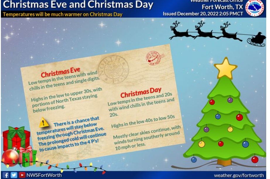
Expect continued cold temperatures on Saturday, with lows and wind chills in the teens and single digits. Afternoon highs will warm up to the low to upper 30s, with only a couple of hours more significant than 32 degrees expected. A low chance remains that everyone will be sub-freezing through Christmas Eve. Remember to protect the four Ps! Christmas Day will start in the teens and 20s for lows and wind chills before warming up into the 40s and 50s for a mild Christmas Afternoon. Skies will be mostly clear, with winds around ten mph or less.
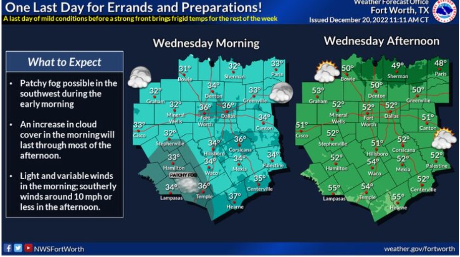
One last mild day before the strong cold front brings a punch of arctic air through the area. An increase in cloud cover will move in overnight and last through much of the afternoon before beginning to clear out somewhat from west to east. Expect low temperatures in the 30s and afternoon highs in the 40s and 50s. By the afternoon, light and variable winds will turn southerly around ten mph or less.
THE WIND CHILL WATCH REMAINS IN EFFECT FROM THURSDAY MORNING THROUGH FRIDAY MORNING
* WHAT – Dangerously cold wind chills are possible. Wind chills as low as 15 below zero.
* WHERE – All of North and Central Texas.
* WHEN – From Thursday morning through Friday morning.
* IMPACTS – The cold wind chills could result in hypothermia if you don’t take precautions.
* ADDITIONAL DETAILS – Wind chills will fall into the single
digits across North Texas Thursday morning, and Central Texas
Thursday afternoon. Wind chills below zero are expected Thursday
evening through Friday morning.
PRECAUTIONARY/PREPAREDNESS ACTIONS
A Wind Chill Watch means the potential for a combination of frigid air and strong winds to create dangerously low wind chill values. Monitor the latest forecasts and warnings for updates on this situation.
South Central and Southwest Arkansas, North Central and Northwest Louisiana, Southeast Oklahoma, and East and Northeast Texas
A Hard Freeze Watch is in effect from 6:00 pm Thursday through Noon Saturday. It is because the forecast calls for the coldest air of the season during this time frame, with bitterly cold temperatures and even colder wind chills.
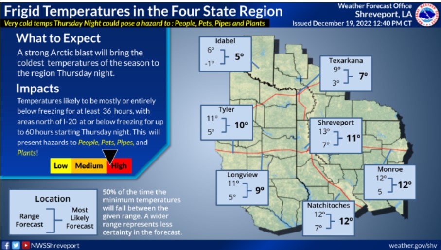
How long will the temperature remain below freezing across your location? First, pick your site on this map, which has the forecast duration of consecutive hours of freezing temperatures. Then, compare this duration to the last significant cold snap in February 2021.
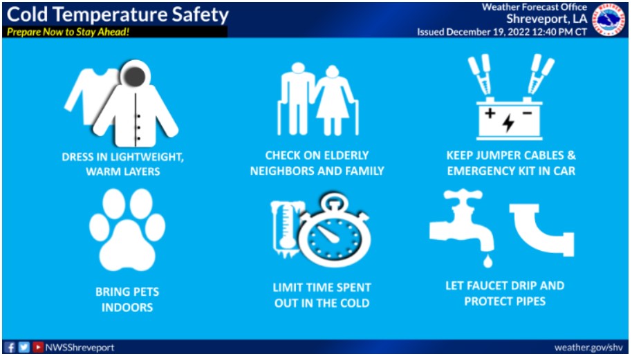
Now is the time to prepare for the cold weather. When frigid temperatures settle in, it is essential to make a plan for these things. Make sure you have layers to dress in, your pets are warm and brought inside, limit time spent in the cold, check on the elderly, and let faucets drip to protect pipes.
WIND CHILL WATCH IS IN EFFECT FROM THURSDAY EVENING THROUGH FRIDAY MORNING
WHAT – Dangerously cold wind chills are likely. Wind chills as low
as 10 to 15 below zero may be possible.
WHERE – Portions of South-Central and Southwest Arkansas,
North Central and Northwest Louisiana, Southeast Oklahoma and
East and Northeast Texas.
WHEN – From Thursday evening through Friday morning.
IMPACTS – The cold wind chills could result in hypothermia if you don’t take precautions.
PRECAUTIONARY/PREPAREDNESS ACTIONS
Monitor the latest forecasts for updates on this situation.
HARD FREEZE WATCH IS IN EFFECT FROM THURSDAY EVENING THROUGH SATURDAY MORNING
Wednesday through Monday.
Please listen to NOAA Weather Radio or go to weather.gov on the Internet for more information about the Hard Freeze Watch.
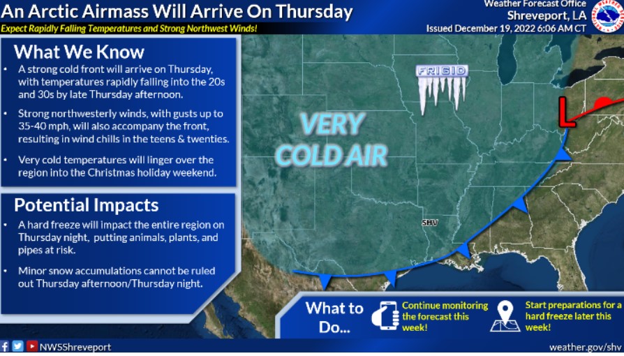
A windy surge of frigid Arctic air will be arriving late on Thursday afternoon, with a slight chance of wintry precipitation for Southeast Oklahoma into Southwest Arkansas and maybe extreme Northeast Texas and even some of North Louisiana as rain showers will change to snow showers. However, you should not expect any accumulations from wintry precipitation that may fall with the ground temperatures just too warm.
The primary concern at this time will be the duration of this icy air mass. It is from Thursday night’s single digits and remaining below freezing all day on Friday with highs only in the twenties, and then lows again during Friday night will fall back down into the teens. We will finally be warming back above freezing by noon on Christmas eve. So make preparations for this Arctic air invasion before Thursday night.
HARD FREEZE WATCH REMAINS IN EFFECT FROM THURSDAY EVENING THROUGH SATURDAY MORNING
WHAT – Sub-freezing temperatures ranging from 4 to 12 degrees possible. In addition, wind chill values below 0 degrees will be possible.
WHERE Portions of South-Central and Southwest Arkansas, North-Central and Northwest Louisiana, Southeast Oklahoma and East and Northeast Texas.
WHEN – From Thursday evening through Saturday morning.
IMPACTS – Frost and freeze conditions could kill crops, other sensitive vegetation and possibly damage to unprotected outdoor plumbing.
PRECAUTIONARY/PREPAREDNESS ACTIONS
Take steps now to protect tender plants from the cold. To prevent freezing and possible bursting of outdoor water pipes, they should be wrapped, drained, or allowed to drip slowly. Those that have in-ground sprinkler systems should drain them and cover above-ground pipes to protect them from freezing.