


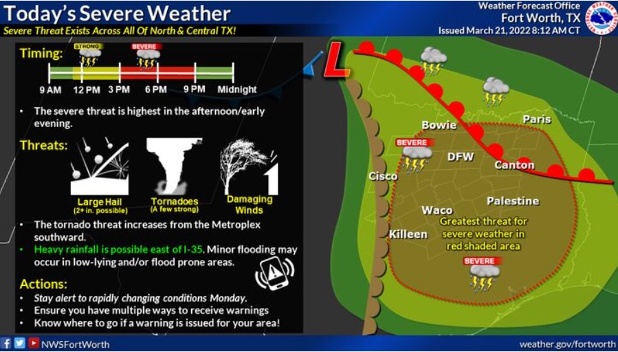
North and Central Texas
.Today and Tonight
Strong to severe thunderstorms will be possible across much of North and Central Texas. Large hail, damaging winds, and several tornadoes will be possible. A few tornadoes may be substantial.
Heavy rain will pose a hazard this afternoon and tonight as minor flooding will be possible mainly across East Texas.
In addition to the severe weather threat, strong southeasterly non-thunderstorm winds gusting to 45 mph will be possible along and east of I-35.
Tuesday through Sunday
Expect no hazardous weather at this time.
SPOTTER INFORMATION STATEMENT
Spotter activation is likely this afternoon throughout North and Central Texas.
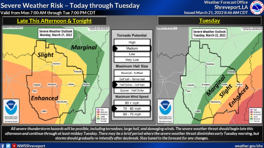
South Central and Southwest Arkansas, North Central and Northwest Louisiana, Southeast Oklahoma, and East and North East Texas
South Central and Southwest Arkansas, North Central and Northwest Louisiana, and East and Northeast Texas
Tonight
Scattered showers and a few thunderstorms will become more numerous this evening as storms intensify over Central Texas and spread east into East Texas, Southeast Oklahoma, and Southwest Arkansas. Some of these storms may become severe, with large hail, damaging winds, and isolated tornadoes possible. These storms are expected to slow as they enter Northwest Louisiana late this evening into the overnight hours, with the threat for locally heavy rainfall and flash flooding increasing over portions of Southwest Arkansas, Northwest Louisiana, and Lower East Texas.
While rainfall amounts will range from two to four inches over much of the region through tonight, locally higher amounts in excess of six inches will be possible.
Tuesday through Sunday
Showers and thunderstorms will be ongoing across Southern Arkansas, North Louisiana, and Deep East Texas Tuesday morning, with the severe and flash flood threats continuing over these areas before diminishing from west to east through early afternoon. Afterward, cooler and drier conditions will settle back into the region for the remainder of the week into the weekend.
SPOTTER INFORMATION STATEMENT
Activation of emergency management personnel, amateur radio operators and storm spotters will be needed this evening and overnight across East Texas, Southwest Arkansas, and Northwest Louisiana.