


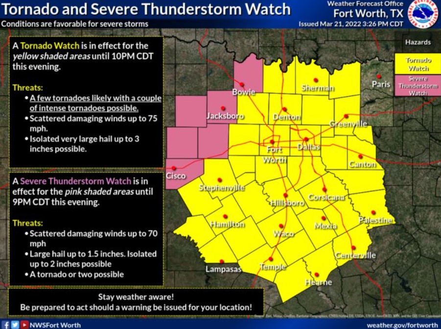
North and Central Texas
Tonight
Strong to severe thunderstorms will be possible across much of North and Central Texas. Large hail, damaging winds, and several
tornadoes will be possible. A few tornadoes may be substantial.
Heavy rain will be possible this afternoon and tonight. As a result, minor flooding may occur across East Texas. In addition to the severe weather threat, strong southeasterly non-thunderstorm winds gusting to 45 mph will be possible along and east of I-35.
Tuesday through Sunday
Elevated fire weather concerns return during mid-week and through the weekend into early next week.
SPOTTER INFORMATION STATEMENT
Spotter activation is likely this throughout North and Central Texas.
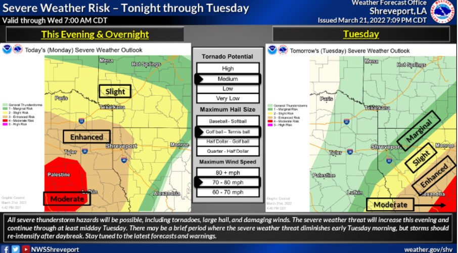
Southwest and Northwest Louisiana, East and Northeast Texas
Tonight
Tornado Watch 56 is in effect until 3:00 am Tuesday, a Wind Advisory is in effect until 1:00 am Tuesday, and a Flood Watch is in
effect until 4:00 am Tuesday.
Thunderstorms will continue to increase in coverage and intensity tonight and into early Tuesday morning. A line of storms will also move into the area from the west. These storms may be severe. Tornadoes, large hail, possibly up to two inches in diameter, and damaging winds up to 80 mph will be possible.
Expect the line of storms to stall across East Texas, Northwest Louisiana, and Southwest Arkansas. Widespread rainfall of two to four inches is possible with locally higher amounts of six inches or greater. Therefore, a Flood Watch is in effect until 4:00 pm Tuesday.
In addition, strong and gusty southeasterly winds of 20 to 25 mph with gusts above 30 mph will continue before the storms arrive. Therefore, a Wind Advisory is effective until 1:00 am Tuesday.
Tuesday through Sunday
Showers and thunderstorms will be ongoing across Southern Arkansas, North Louisiana, and Deep East Texas Tuesday morning, with the severe and flash flood threats continuing over these areas before diminishing from west to east through early afternoon. Afterward, cooler and drier conditions will settle back into the region for the remainder of the week into the weekend.
SPOTTER INFORMATION STATEMENT
Activation of emergency management personnel, amateur radio operators and storm spotters will be needed tonight, overnight, and into Tuesday morning.