


North and Central Texas
Today and Tonight
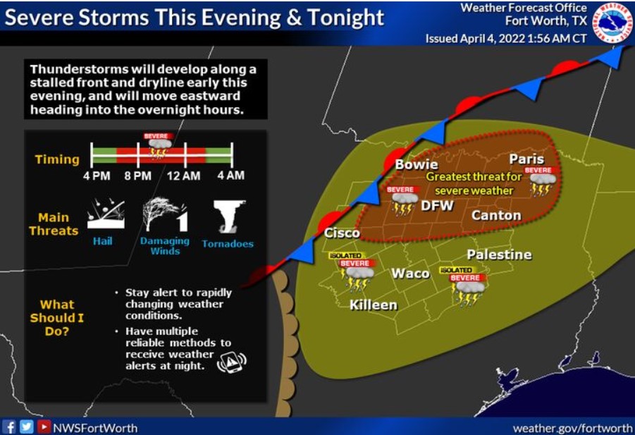
Scattered to numerous thunderstorms are expected across much of the region late this afternoon and evening. All modes of severe weather are possible late today and tonight, with large hail, damaging winds, and a few tornadoes possible, especially with more discrete storms.
Locally heavy rainfall between 1 to 2 inches, with isolated more serious amounts, is possible across eastern North Texas. It may
cause instances of minor urban and small stream flooding. However, the forecast does not expect flash flooding.
Tuesday through Sunday
The NWS does not anticipate any hazardous weather.
SPOTTER INFORMATION STATEMENT
Spotter activation is likely beginning late this afternoon and continuing through tonight across all of North and Central Texas.
South Central and Southwest Arkansas, North Central and Northwest Louisiana, Southeast Oklahoma, and East and Northeast Texas
Today and Tonight
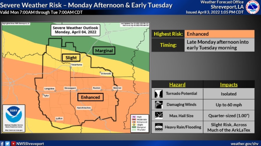
Today and this afternoon, thunderstorms are possible across Southeast Oklahoma and adjacent portions of Northeast Texas and Southwest Arkansas. Thunderstorm chances will increase dramatically across Southeast Oklahoma and East Texas this evening as a line of intense to severe storms develops and moves into the area. The thunderstorms will progress eastward across the remainder of the area tonight and Tuesday morning. Damaging winds will be the primary threat, but isolated tornadoes and large hail will be possible. In addition, locally heavy rainfall amounts could result in isolated flooding. Except for Deep East Texas, most locations could receive over an inch of rainfall. An axis of heavier rainfall amounts between two and three inches will be possible along the Interstate 30 corridor.
Tuesday through Sunday
Thunderstorms are likely across Southern Arkansas and Northeast and North Central Louisiana Tuesday morning, mainly east of a line from Magnolia, AR, to Many, LA. Some storms could be severe. Damaging winds will be the primary threat, but isolated tornadoes and large hail will be possible. In addition, locally heavy rainfall amounts could result in isolated flooding. The storms should exit the area by late Tuesday morning.
Thunderstorms are possible Wednesday afternoon across portions of Southern Arkansas and Northeast and North Central Louisiana but don’t anticipate severe weather.
SPOTTER INFORMATION STATEMENT
Activation of emergency management personnel, amateur radio operators and storm spotters will be needed this evening through
Tuesday morning.