


North and Central Texas
Today and Tonight
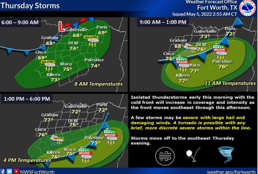
A cold front and upper-level system will impact the region today. A cold front will enter western areas shortly after daybreak, then move readily southeast through the day before exiting the Lower Brazos/Trinity Valley areas just before sunset. Initially, expect isolated storms in nature and sub-severe, but with daytime heating and better moisture along and south of the I-20/30 corridors, expect a line of strong to severe storms to fill in along the cold front. The primary hazards will be damaging winds to 65 mph and large hail up to ping pong size. However, if any severe storms can become briefly more discrete, a tornado or two would be possible.
Thunderstorms will develop along a cold front across North and Central Texas, accompanied by a severe weather threat. The severe threat will be highest from midday into the afternoon, mainly east of I-35 and south of I-20. Damaging winds will be the main threat, along with locally heavy rainfall.
Friday through Wednesday
Isolated thunderstorms may develop along a dryline Sunday through
Tuesday west of I-35. Any storms could be severe.
SPOTTER INFORMATION STATEMENT
The NWS could activate spotters later today.
South Central and Southwest Arkansas, North Central and Northwest Louisiana, Southeast Oklahoma, and East and Northeast Texas
Today and Tonight
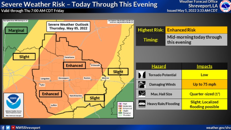
Showers and thunderstorms will increase later this morning across Northeast Texas, Southeast Oklahoma, and Southwest Arkansas before spreading into Deep East Texas and North Louisiana during the afternoon. Some of these storms will be severe, with damaging winds, hail, and isolated tornadoes possible. Locally heavy rainfall will also accompany the stronger storms, resulting in localized flooding. Widespread rainfall of one to three inches is expected this evening, with isolated higher amounts of over four inches possible. These storms will diminish from west to east late this afternoon through tonight.
Friday through Wednesday
The NWS does not expect any hazardous weather.
SPOTTER INFORMATION STATEMENT
Activation of emergency management personnel, amateur radio operators and storm spotters will likely be needed today through
this evening.