


This Hazardous Weather Outlook is for portions of South Central
Arkansas, Southwest Arkansas, North Central Louisiana, Northwest
Louisiana, Southeast Oklahoma, North Texas, East Texas and Northeast Texas.
Showers and a few thunderstorms will increase across much of East
Texas, Southeast Oklahoma, Southwest Arkansas, and Western
Louisiana this afternoon, ahead of a healthy upper-level system that will slowly shift east across Oklahoma. A warm front
will begin to move north into East Texas, North Louisiana, and
possibly extreme Southern Arkansas late this afternoon and
evening. It will cause showers and thunderstorms to intensify near
and south of this boundary where weak instability interacts with
moderate wind shear and large-scale forcing ahead of this storm
system. It may result in the development of isolated strong to
severe thunderstorms tonight over East Texas and portions of North
Louisiana, with damaging winds and marginally severe hail
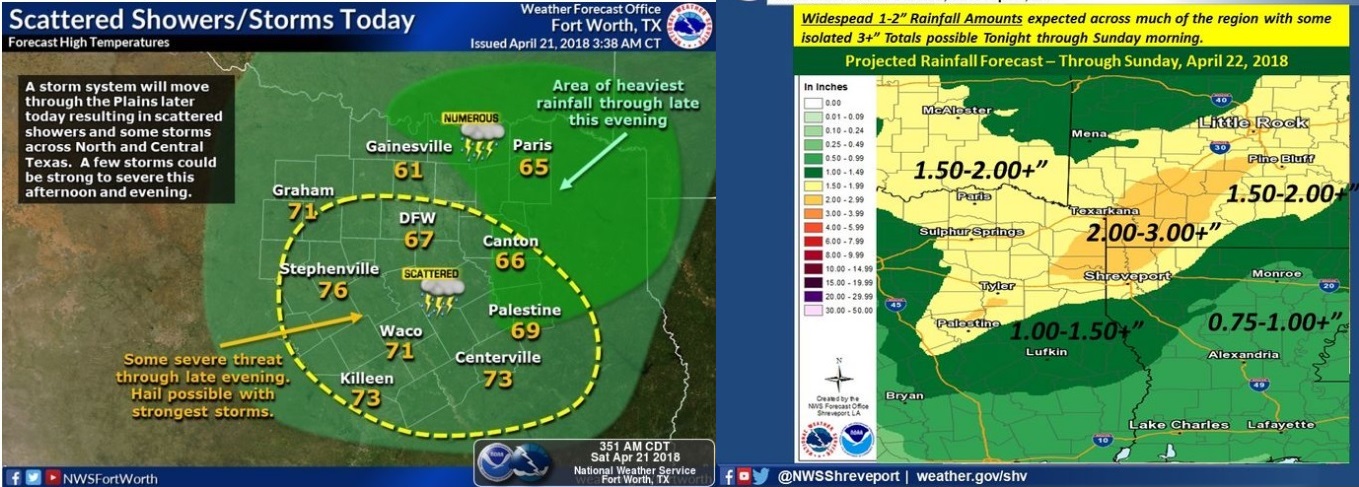
possible. However, the primary threat will be locally heavy
rainfall, as widespread rainfall amounts of one to two inches,
with isolated higher amounts of over three inches possible
areawide. It may result in minor flooding of low lying, poor
drainage areas before the showers and thunderstorms diminish from
west to east late tonight.
Showers and isolated thunderstorms will diminish across
Southcentral Arkansas and Northcentral Louisiana Sunday morning as this storm system shifts east across Arkansas into Northern
Mississippi. Scattered showers and isolated thunderstorms will
return to the region Wednesday and Friday, near and ahead of a
couple of cold fronts that will move through the area. However, the National Weather Service does not expect any hazardous weather.
.SPOTTER INFORMATION STATEMENT
Activation of emergency managers, spotter networks, and amateur
radio operators may be needed tonight for isolated severe
thunderstorms and the potential for minor flooding.