


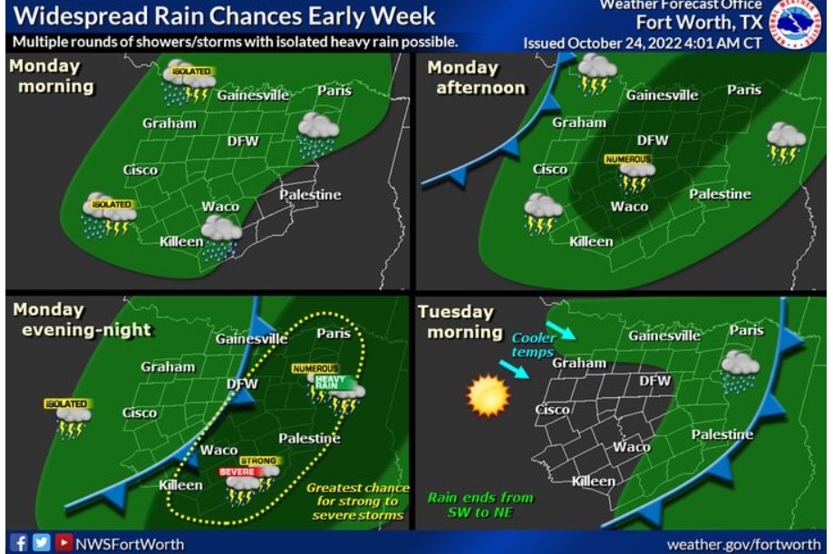
North and Central Texas
Multiple showers and storms are expected over Monday ahead of an incoming cold front. A few strong to severe storms are possible during the afternoon and evening, mainly along and east of I-35. The main concerns are damaging winds, though hail, and you cannot rule out a couple of tornadoes. Rain will end early Tuesday morning from southwest to northeast with steadily clearing skies.
Monday and Monday Night
There is a slight chance of thunderstorms this morning west of the
I-35 corridor. Isolated damaging wind gusts and lightning will be
the primary hazard.
Strong to severe storms will be possible Monday afternoon and
evening, mainly across eastern portions of North and Central Texas.
Damaging winds are the main threat, though some hail, and you cannot rule out a couple of tornadoes at this time. In addition, periods of heavy rainfall may lead to isolated flash flooding. Storm chances will generally end late Monday night.
Tuesday through Sunday
Another round of showers and storms is expected Thursday night into Friday. However, severe weather appears unlikely at this time.
SPOTTER INFORMATION STATEMENT
The NWS does not expect spotter activation at this time.
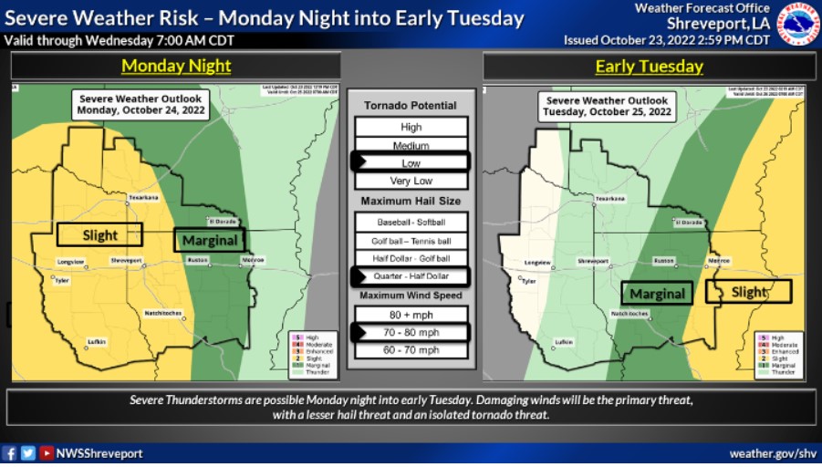
South Central and Southwest Arkansas, North Central and Northwest Louisiana, Southeast Oklahoma, and East and Northeast Texas
Monday afternoon and night
Expect a powerful late October storm system to move through the Four State region Monday night and early Tuesday. It will threaten severe thunderstorms, particularly in East Texas and Western Louisiana. Damaging winds will be the primary threat, with a lesser hail threat. Isolated tornadoes will also be possible. In addition, gusty south winds and low relative humidities will contribute to the
ignition and spread of wildfires across the region today, given the
critically dry fuels in place. Therefore, outdoor burning activities are
strongly discouraged.
Monday through Saturday
Showers and thunderstorms will increase Monday across
portions of East Texas, Southeastern Oklahoma, and adjacent parts of Southwestern Arkansas. They will spread east across the remainder of the region Monday night and Tuesday ahead of a cold front and a robust upper-level storm system. A few severe storms will be possible Monday night into Tuesday morning. Damaging winds should be the primary threat, but large hail is possible, and you can’t rule out an isolated tornado.
Scattered showers and isolated thunderstorms will be possible on
Friday. The NWS will monitor this system for a potential late-week severe weather threat.
SPOTTER INFORMATION STATEMENT
Spotter activation may be needed Monday night into early Tuesday.