


North and Central Texas
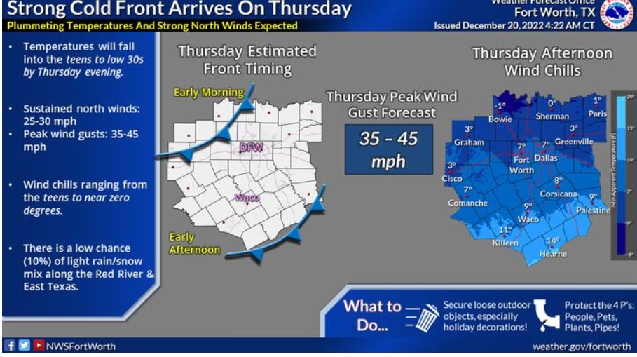 Much colder temperatures arrive on Thursday as a cold front surges south across much of the U.S. The exact timing on the front is still uncertain. Regardless, most of the day’s high temperature will likely occur during the morning hours, with temperatures falling sharply throughout the day. Peak wind gusts near 45 mph are likely, and it is possible for higher wind gusts. It will result in wind chill values in the single digits and teens.
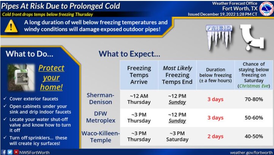
A long duration of well below-freezing temperatures and windy conditions will damage exposed outdoor pipes and cause them to burst. Temperatures fall below freezing Thursday and will remain below freezing until Sunday, Christmas Eve, for most, except for those across Central Texas. There is a slight chance that temperatures will stay below freezing everywhere through Sunday, Christmas Day. Cover outdoor pipes, and let indoor faucets drip. Locate your water shut-off valve, know how to turn it off, and remember to turn off sprinklers!
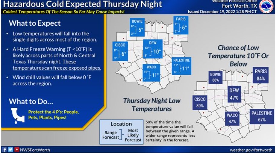
Low temperatures will fall into the teens and single digits Thursday night. A hard freeze, with temperatures less than or equal to 10F, is likely across North and Central Texas. These temperatures can freeze exposed pipes! Wind chill values will fall below 0F across the region. Take the necessary actions to protect the 4 P’s: people, pets, plants, and pipes!
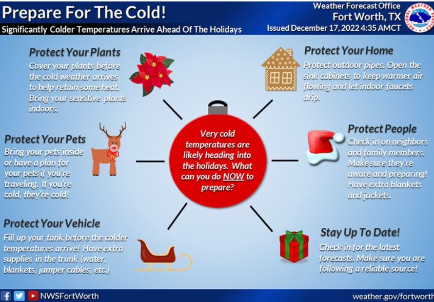
Take advantage of the better days to prepare for the significantly colder temperatures Thursday through the holiday weekend. You can take action now, including protecting your home, vehicle, and plants. You can also check in on neighbors and friends and help prepare them if needed. Always bring your pets indoors! A hard freeze will likely impact North and Central Texas on Thursday night.
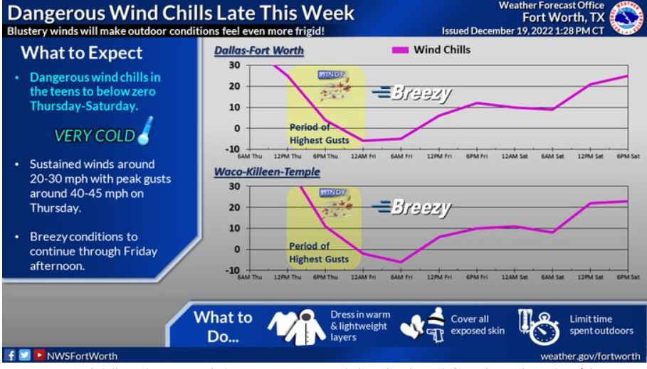 Dangerous wind chills in the teens to below zero are expected Thursday through Saturday in the wake of the strong Arctic cold front. Blustery winds around 20-30 mph, gusts around 40-45 mph, and sharply falling temperatures will make Thursday feel even colder. The highest gusts will occur in the morning and afternoon hours on Thursday. Breezy conditions will continue on Friday. Make sure to dress warmly, cover exposed skin, and limit your time outdoors!
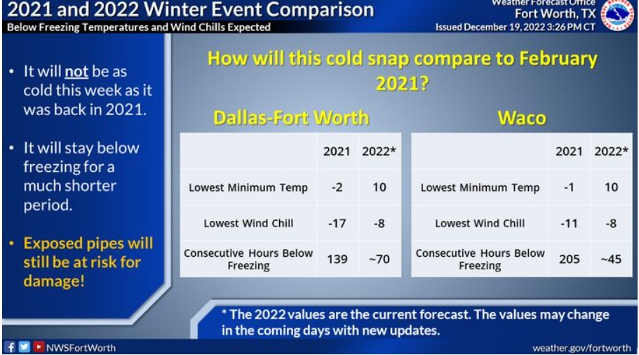
How will this cold snap compare to February 2021? Well, it will not be as frigid and will stay below freezing for a shorter duration this week. However, outdoor pipes and faucets will still be at risk for damage! The forecast may change, so continue to check for new updates.
Today and Tonight
Fog will be possible through the morning hours, with a few areas of dense fog possible across western Central Texas, where visibility may fall well below a mile.
Wednesday through Monday
An arctic front will arrive on Thursday, ushering in bitter-cold temperatures. Some very light snow or, more likely, flurries may occur briefly behind the front Thursday. Do not expect any travel impacts.
A hard freeze is expected Thursday night into Friday morning for nearly the entire region, which could result in damage to unprotected pipes and exterior faucets.
In addition, very gusty north winds with gusts reaching 35 to 45 mph will be possible by Thursday afternoon and continue through Thursday evening before diminishing overnight into Friday morning.
The winds and sub-freezing temperatures will create wind chills from 5 to 15 degrees below zero across the entire region Thursday night into Friday morning.
Sub-freezing temperatures will persist through at least Christmas Eve.
SPOTTER INFORMATION STATEMENT
The NWS does not expect spotter activation at this time.
South Central and Southwest Arkansas, North Central and Northwest Louisiana, Southeast Oklahoma, and East and Northeast Texas

By far, the coldest air of the season will be moving into the Four State Region on Thursday and will remain anchored across our region through the upcoming Holiday Weekend. Therefore, you should act this week to prepare for this bitterly cold arctic air.

Expect bitterly cold temperatures to move into the region starting Thursday night. But just how low will it get? Additional guidance usually gives us different solutions on how cold or warm it could get. However, they typically fall within a range. This graphic depicts different probabilities for how hard the freeze could get, the most likely scenario, and the higher end of the temperature range.
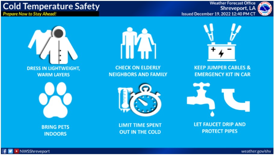
Now is the time to prepare for the cold weather. When frigid temperatures settle in, it is essential to make a plan for these things. Make sure you have layers to dress in, your pets are warm and brought inside, limit time spent in the cold, check on the elderly, and let faucets drip to protect pipes.
Tuesday through Sunday
Expect a strong surge of frigid Arctic air to arrive by Thursday, with a slight chance of wintry precipitation. However, the primary concern will be the extreme cold, with a prolonged period of below-freezing temperatures into the Christmas weekend.
SPOTTER INFORMATION STATEMENT
The NWS does not expect spotter activation at this time.