


Today and Tonight (May 8)
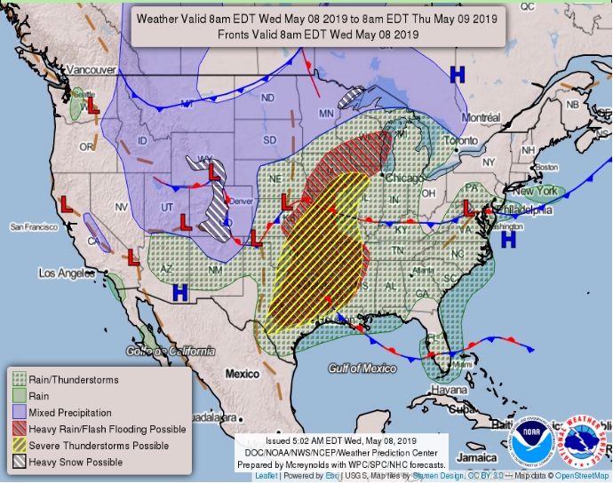
A line of thunderstorms will move across the region today, bringing a chance for damaging winds, large hail, and heavy rainfall along with localized flooding. A tornado or two cannot be ruled out.
Storms will affect locations generally west of the I-35 corridor this
morning and the remainder of the region this afternoon and early
evening.
For Southern Arkansas, North and Northwest Louisiana, East and Northeast Texas and Southeast Oklahoma can expect additional development everywhere as the muggy airlifts ahead of the approaching complex of thunderstorms.
Daytime heating will produce widespread thunderstorms, and some may become severe with tornadoes, damaging winds, and large hail. Also, a cool-front will arrive late today and end up bisecting the region. The front is a slow mover, and training of
thunderstorms will bring the potential for flash flooding with a
watch already in effect for today. Some 2 to 4 inches of rainfall will be typical for many locales. Be prepared for various storm warnings today.
Thursday through Tuesday (May 9-14)
Scattered to numerous thunderstorms are expected Thursday through Saturday as well as Monday and Tuesday of next week. Localized flooding will be the primary hazard, although a few storms could produce small hail.
The cool-front will slowly drift Southeast and remain the focus for storm development. We will continue with numerous showers and some severe thunderstorms possible during the day as it pulls up stationary. Another upper storm will move over on Friday, and then a third is expected late Saturday. Finally, a little more productive cool-front to give us a break from the weekend flash flooding threat and drive the storm activity to our South. Some four to eight inches of rainfall will be possible with some higher amounts through Sunday.
A Flash Flood Watch is in effect for Southeast Oklahoma,
Southwest Arkansas, the Northern two-thirds of Northeast Texas,
and portions of Northern Louisiana.
Spotter Information Statement
Spotter activation may generally be requested west of the I-35
corridor this morning and east of I-35 Wednesday and
Thursday afternoons.