


North and Central Texas.
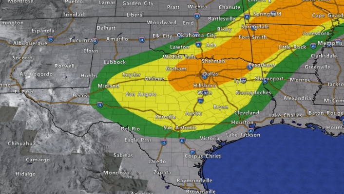
Severe thunderstorms are possible across all of North and Central Texas today with the best chances generally north of the I-20. The hazards associated with these storms include large hail, damaging winds, and some tornadoes. Heavy rainfall and flash flooding will also be possible, especially north of I-20.
Thunderstorm chances will decrease from northwest to southeast
tonight.
Thursday through Tuesday.
Scattered thunderstorms are possible across Central Texas Thursday. Severe storms are not anticipated. Isolated to scattered thunderstorms will remain in the forecast
Friday through Tuesday. Widespread severe weather is not expected at this time.
SPOTTER INFORMATION STATEMENT
Spotter activation is possible west of the I-35 corridor this morning and east of I-35 this afternoon and evening.
South Central Arkansas, Southwest Arkansas, North Central Louisiana, Northwest Louisiana, East, and Northeast Texas
Showers and thunderstorms will begin moving into the area late this e evening and through much of the overnight hours. Brief heavy and strong gusty winds are possible with a few storms that develop.
Thursday through Tuesday
A few showers and thunderstorms could redevelop during the day Thursday, followed by a relatively quiet, but warm and humid weekend. Thunderstorms could begin to increase by early next week gradually. However, no hazardous weather is expected at this time.
SPOTTER INFORMATION STATEMENT
Activation of emergency management personnel, amateur radio operators, and storm spotters are not anticipated at this time for Wednesday night.
Flash Flood Warning
Titus, Franklin at 10:12 pm Wednesday until Thursday (May 30).