


This Hazardous Weather Outlook is for North and Central Texas.
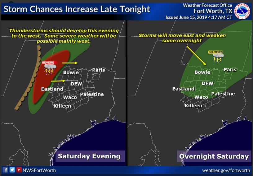
Thunderstorm chances will increase tonight across much of North Texas as storms approach from the west. These storms should weaken during the overnight hours as they approach the I-35 corridor. Damaging winds would be the main threat with any storms tonight.
This Hazardous Weather Outlook is for portions of South Central
Arkansas, Southwest Arkansas, North Central Louisiana, Northwest Louisiana, Southeast Oklahoma, East Texas, and Northeast Texas.
Isolated to widely scattered showers and thunderstorms will be possible this afternoon across portions of Deep East Texas and North Louisiana, as a weak sea breeze, pushes north from the Gulf of Mexico. Brief heavy rainfall and locally gusty winds will be possible in the stronger storms before they diminish by or shortly after sunset. However, a complex of showers and thunderstorms will shift east across North Texas late tonight, entering portions of Northeast Texas, Southeast Oklahoma, and possibly Southwest Arkansas just before daybreak Sunday. These storms may also produce brief heavy rainfall and locally gusty winds as they begin to weaken late tonight.
Sunday through Friday
Thunderstorm chances will continue Sunday through much of the week across a good portion of North and Central Texas. The highest chances for storms will be on Sunday and Monday. Some severe weather will be possible on Sunday with damaging winds being the main threat. Also, areas that receive multiple rounds of rain could have some localized flooding issues.
Boundaries leftover from the early Sunday morning showers and thunderstorms will help focus additionally scattered to numerous showers and thunderstorms across the region Sunday, as weak upper-level disturbances lift northeast across the area. While these showers and thunderstorms are expected to diminish Sunday evening, another thunderstorm complex will move into portions of extreme Northeast Texas, Southeast Oklahoma, and Southwest Arkansas early Monday morning, and shift southeast across much of the area during the day. Given the extent of instability expected both Sunday and Monday, isolated severe thunderstorms capable of producing damaging winds and locally heavy rainfall will be possible, with the threat for localized flash flooding. Additional scattered showers and thunderstorms will be possible Tuesday through Thursday as further upper-level disturbances move into the region.
SPOTTER INFORMATION STATEMENT
Limited spotter activation may be requested tonight mainly across our northwest counties, west of I-35. Activation of emergency management personnel, amateur radio operators, and storm spotters should not be needed through tonight east of I-35.