


Flash Flood Warning for Hopkins and Wood counties starting at 3:00 pm Sunday
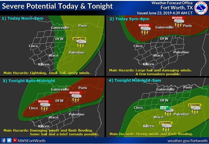
Today and Tonight
This Hazardous Weather Outlook is for North and Central Texas.
Isolated thunderstorms are possible this morning into the early afternoon hours, mostly across North and East Texas. Lightning would be the main hazard with this activity.
Late this afternoon and evening, widespread thunderstorms are expected to affect the area as they spread in from the north. A threat for large hail, damaging winds, and tornadoes will exist across North Texas through the evening hours, with localized flooding possible as well. Primarily, an active wind threat is expected as activity shifts south of I-20 tonight, with continued potential for heavy rainfall and flash flooding lingering into the pre-dawn hours on Monday.
South Central Arkansas, Southwest Arkansas, North Central Louisiana, Northwest Louisiana, East Texas, and Northeast Texas.
Expect scattered showers and thunderstorms this afternoon to increase in coverage and intensity late this evening into the overnight. Expect this activity to form along and ahead of a squall line that is forecasted to move southeast across the region tonight. Some storms may become severe this evening into early Monday morning with damaging winds, large hail, and isolated tornadoes possible. Localized heavy rainfall and isolated flash flooding will also be a possibility.
Monday through Saturday
Additional thunderstorms are possible on Monday, although the coverage of storms will depend on how widespread activity is on Sunday night. A threat for intense thunderstorms and further heavy rainfall could exist through the day.
Lower thunderstorm chances will continue through the rest of the week, mostly during the afternoon and evening hours each day. The highest chances will be along and east of I-35.
Spotter activation may be requested late this afternoon through tonight, especially along and north of the I-20 corridor. An unsettled pattern will set up over the Four State Region for the upcoming week. For the most part, daytime heating will lead to the chance for showers and thunderstorms to remain in the forecast through next weekend. Some of the stronger storms may produce locally gusty winds and brief, heavy rainfall each day.
SPOTTER INFORMATION STATEMENT
Activation of emergency management personnel, amateur radio operators and storm spotters are requested this evening through Monday morning.