


Today and Tonight
North and Central Texas.
Thunderstorms are expected to develop near the Red River and Big County this afternoon. Large hail, damaging winds, and isolated tornadoes are possible in these regions.
Shortly after developing, these storms should form into a complex that moves south and southeast with a threat for damaging winds and hail. The main threat for severe weather should remain along and north of I-20, although a damaging wind threat exists as far south as a line extending from Killeen, Waco to Canton.
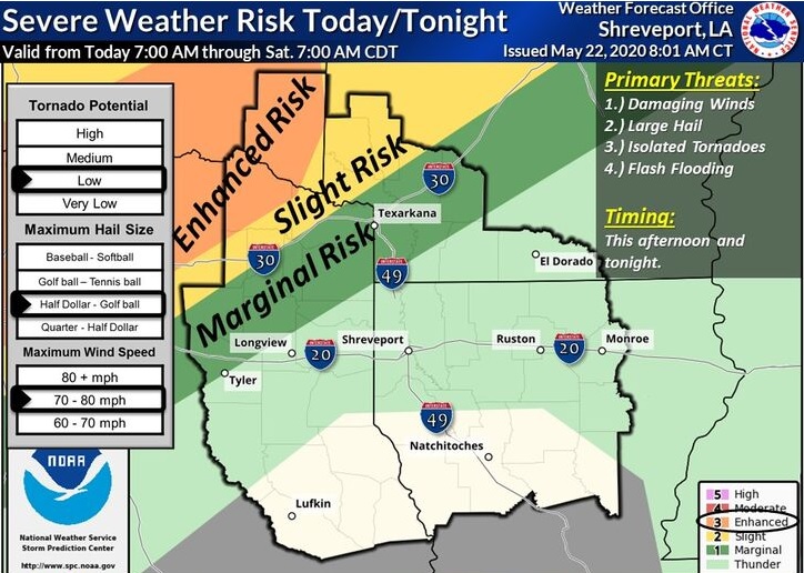
South Central Arkansas, Southwest Arkansas, North Central Louisiana, Northwest Louisiana, Southeast Oklahoma, East Texas, and Northeast Texas
Showers and thunderstorms across Central Oklahoma this morning will possibly drift southeast into portions of extreme Northeast Texas, Southeast Oklahoma, and Southwest Arkansas today. Some of these storms may be severe with large hail, damaging winds, and isolated tornadoes, along with locally heavy rainfall.
Saturday through Thursday
Thunderstorms will be possible each day as an unsettled weather pattern prevails over the region. Heavy rainfall will be the greatest concern, with flooding issues arising as early as Sunday and Monday. Isolated showers and thunderstorms will be possible across the region this weekend and through much of next week as several disturbances move across the area. No widespread hazardous weather is expected at this time, although locally heavy
rainfall will be possible.
SPOTTER INFORMATION STATEMENT
The need for activation of emergency management personnel, amateur radio operators, and storm spotters is possible today. Please relay any information about observed severe weather to the NWS, while following all local, state, and CDC guidelines. Expect storms this afternoon and tonight, generally along and north of I-20.