


Today and Tonight
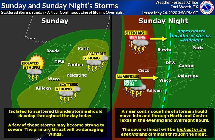
North and Central Texas
Isolated to scattered thunderstorms should develop across North and Central Texas late this morning through the afternoon, some of which may become strong or severe. The primary threat with these storms will be damaging wind gusts and large hail.
Overnight tonight, a line of thunderstorms should move into the area from west to east. The highest severe threat should be in the evening to early overnight hours west of I-35. The primary danger with these storms will be damaging wind gusts. Isolated areas of intense rainfall may lead to localized flooding in the overnight hours as well.
Thunderstorms will be possible each day as an unsettled weather pattern prevails over the region. Heavy rainfall will be the most significant concern, particularly Monday into Tuesday, when flooding issues may arise.
South Central Arkansas, Southwest Arkansas, North Central Louisiana, Northwest Louisiana, Southeast Oklahoma, East Texas, and Northeast Texas
Showers and thunderstorms will increase in coverage today during the late morning through the afternoon hours as low-level moisture will increase ahead of an upper-level disturbance that will move across East Texas. The forecast does not expect widespread organized severe weather at this time. However, heavy rain could lead to localized flooding in some areas.
Monday through Saturday
The Four-State Region will be transitioning into a reasonably wet period through the upcoming work week with a nearly stalled upper-level trough west of the region. It will result in periods of scattered to numerous showers and thunderstorms through much of the extended forecast. Flash Flood Watches may become necessary for portions of the Four-State Region.
SPOTTER INFORMATION STATEMENT
This evening, limited spotter activation is possible in areas west of Highway 281. East of 281, there is no need for the activation of emergency management personnel, amateur radio operators, and storm spotters.