


This line of storms pushed through much of western and central Kansas, before diving into Oklahoma, as the sunset on Father’s Day. These storms left a barrage of damaging wind and hail reports in their wake, including several 80-mph wind gusts and at least one report of 3.25-inch-diameter hail in Lorraine, Kansas.
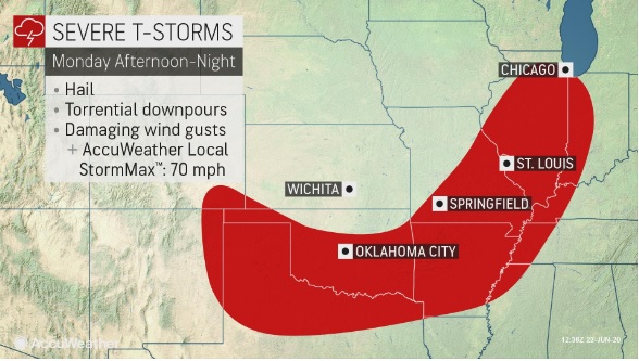
Tumultuous weather will continue on Monday as an area of low pressure centered over the Great Lakes, and an associated cold front stretches from Wisconsin to Texas and prompts stormy weather across much of the central and eastern portions of the United States.
Much of the day’s activity will take the form of typical summertime showers and thunderstorms across the eastern two-thirds of the U.S. However, more potent storms are in store for several locations.
The most widespread threat for severe thunderstorms Monday afternoon through Monday night will exist across portions of the southern Plains through the middle Mississippi Valley. Residents in these areas will need to keep their eye to the sky if traveling outdoors on Monday.
South Central Arkansas, Southwest Arkansas, North Central Louisiana, Northwest Louisiana, Southeast Oklahoma, and Northeast Texas.
Today and Tonight
A line of strong thunderstorms, which may produce gusty winds and brief heavy rainfall will move Southeast across the area today. Redevelopment is possible this afternoon across Southeast Oklahoma, Southwest Arkansas, and Northeast Texas, but this is very uncertain. If thunderstorms redevelop this afternoon, a few storms could be severe. Damaging winds and large hail will be the primary threats. The threat for severe weather should diminish this evening.
North and Central Texas
Thunderstorms will affect parts of North Texas through the morning hours. Heavy rainfall may lead to localized flooding north of I-20. Scattered storms may redevelop later this afternoon. Another round of thunderstorms is expected this evening and overnight, with damaging winds and hail possible. Additional heavy rain may lead to
flooding in portions of North Texas.
Tuesday through Sunday
Expect widespread thunderstorms on Tuesday as a cold front slowly moves into the area. Not ruled out are a couple of severe storms, especially south of the Interstate 30 corridor. Damaging winds and large hail will be the primary threat.
Expect more thunderstorms Wednesday and Thursday, however, do not anticipate severe weather, but multiple rounds of locally heavy rainfall could lead to isolated flooding.
Rain chances will decrease after Thursday but isolated to widely scattered thunderstorms will remain in the forecast Friday through Sunday.
SPOTTER INFORMATION STATEMENT
Activation of emergency management personnel, amateur radio operators, and storm spotters may be needed today and this afternoon. Please relay any information about observed severe weather to the NWS while following all local, state, and CDC guidelines.