


North and Central Texas
Today and Tonight
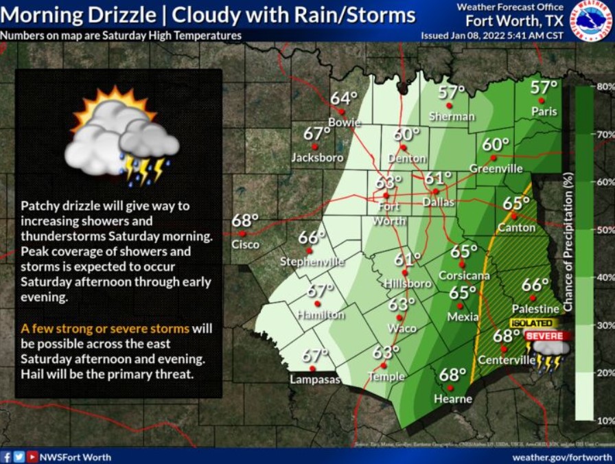
Today and tonight, thunderstorms will be possible near and east of the I-35 corridor. The main hazard will be hail.
Sunday through Friday
Isolated thunderstorms will be possible Thursday night in advance of a cold front.
SPOTTER INFORMATION STATEMENT
You should not expect spotter activation at this time.

Central Southwest, and West Central Louisiana, and Southeast Texas
Today and tonight.
Scattered to numerous showers and thunderstorms will be possible today across much of the region. The area will experience rain with higher chances except East Central and Northeast Louisiana. Showers and thunderstorms will become more widespread as a warm front and upper disturbance move through the area.
The Storm Prediction Center has outlined areas southwest of Leesville to Abbeville in a Marginal Risk, a category one-out-of-five, potential for severe weather. The main hazards will be a brief spin
up of a tornado and damaging wind gusts.
In addition, the Weather Prediction Center has outlined areas west of the Sabine River in a Marginal Risk for excessive rainfall. Localized
rainfall amounts could reach two to three inches in isolated locations.
Sunday through Friday
The Storm Prediction Center maintains a Marginal Risk of a category one-out-of-five for potential severe weather for most of the area on
Sunday. Meaning that area could have stronger storms, an isolated brief spin-up of tornadoes, damaging straight-line wind gusts, or marginally severe hail.
A light freeze is possible for Monday night into Tuesday morning for
portions of interior Southeast Texas and Central Louisiana.
SPOTTER INFORMATION STATEMENT
You should not expect spotter activation at this time.