


North and Central Texas
Today and Tonight
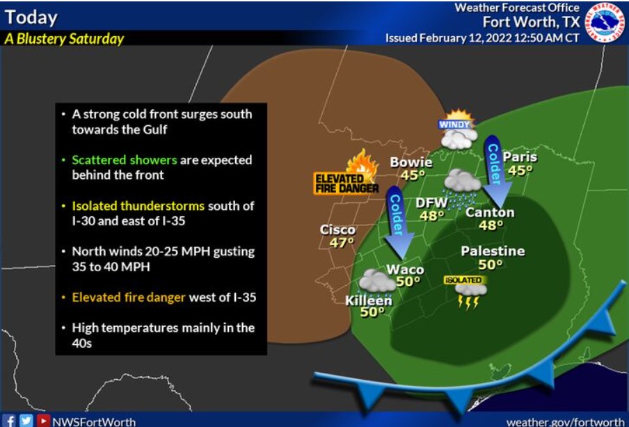
An isolated thunderstorm can`t be ruled out this morning across East Texas without severe weather. Wind gusts up to around 40 mph will be possible across Central Texas this morning in the wake of a cold front.
Sunday through Friday
There will be a threat for storms Wednesday afternoon into early Thursday morning, as a robust system moves overhead. We continue to monitor the danger of strong to severe storms, but NWS does not expect widespread severe weather at this time.
South Central and Southwest Arkansas, North Central and Northwest Louisiana, Southeast Oklahoma, and East and Northeast Texas.
Today and Tonight
A strong cold front will continue to push through the region early this morning, bringing with it much cooler temperatures and brisk north winds. Showers and an occasional thunderstorm will be possible in the wake of this cold front today. No strong to severe thunderstorms are forecast through tonight.
Sunday through Friday
Showers and thunderstorms will increase once again Wednesday afternoon through Thursday, ahead of a robust upper-level storm system that will eject northeast across West Texas into Oklahoma. The potential will exist for strong to severe thunderstorms across the region Wednesday night and Thursday morning, before cooler and drier conditions return in the wake of a cold frontal passage Thursday afternoon and night.
SPOTTER INFORMATION STATEMENT
The NWS will not need to activate emergency management personnel, amateur radio operators, and storm spotters now until tonight.
Please relay any information about observed severe weather to the NWS while following all local, state, and CDC guidelines.