


North and Central Texas.
Major Winter Storm Poised To Impact The Region Sunday And Monday.
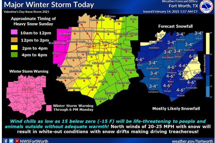
Conditions will continue to deteriorate through the day, with periods of light snow and sleet. The heaviest snow and sleet can be expected this afternoon through early Monday morning. Strong winds will lead to blowing and drifting snow with wind chills falling below zero tonight. Snow will come to an end Monday morning, but icy conditions will persist through mid-week. The heavy snow and forecast long duration of frigid temperatures will likely lead to significant stress on the region’s infrastructure as well as crippling travel for several days.
A Winter Storm Warning is in effect until 6:00 pm Monday.
Expect heavy mixed precipitation and total snow and sleet accumulations of 4 to 8 inches along with light icing due to light freezing rain and drizzle. Some snow drifts of over 8 inches are possible. Strong winds will result in very restricted visibility and possibly life-threatening wind chills, actual air temperatures in the single digits and low teens.
Travel could be challenging, if not impossible, late today into Monday. Extreme wind chills as low as 15 below zero will become life-threatening to people and animals outside without adequate warmth or shelter! The strong winds could also result in blowing and drifting snow, yielding near whiteout conditions with visibility less than 1/2 mile. Morning temperatures in the single digits and low teens could severely damage plumbing, mostly if pipes are not insulated!.
Preparedness Action
If you must travel, keep an extra flashlight, food, and water in your vehicle in case of an emergency. You can find the latest road conditions for Texas at drivetexas.org.
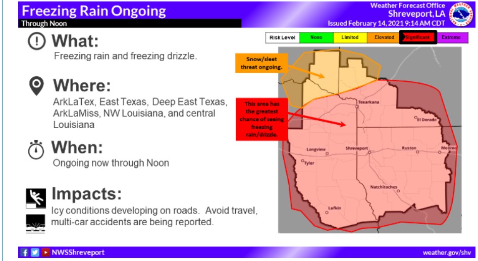
South-Central Arkansas, Southwest Arkansas, North-Central Louisiana, Northwest Louisiana, Southeast Oklahoma, East, and Northeast Texas.
Expect a significant winter storm to impact the entire Four State region with a mix of snow, sleet, and freezing rain from today into Monday. Conditions are forecast to deteriorate today as a wintry mix of precipitation develops areawide. The heaviest precipitation, however, will be late tonight into Monday.
Winter Storm Warning is in effect until 6:00 pm Monday.
Wind Chill Advisory is in effect from midnight Sunday to 6:00 pm Monday.
There will be heavy mixed precipitation expected. Total snow accumulations of 3 to 5 inches possible across deep East Texas into Northwest Louisiana and South-Central Arkansas with lesser amounts elsewhere. Sleet accumulations of around 1 inch and ice accumulations of roughly one-quarter of an inch possible across North-Central and Northeast Louisiana. For the Wind Chill Advisory, frigid wind chills expected. Wind chills as low as five below zero across Southeast Oklahoma and in the single digits elsewhere.
Monday
Wind Chill Advisory, through 6:00 pm Monday. Expect power outages and tree damage due to the ice. Travel could be nearly impossible due to snow, sleet, and ice accumulations. The cold wind chills could result in hypothermia if you do not take precautions.
If you must travel, keep an extra flashlight, food, and water in your vehicle in case of an emergency. Use caution while traveling outside. Wear appropriate clothing, a hat, and gloves.