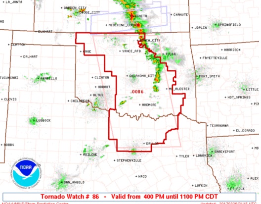
Mid-level shortwave to move into west-central Arkansas tonight
allowing for sufficient instability to support strong to severe
convection mainly along the I-30 corridor. Moisture, however, an essential ingredient in convective development is still lacking.
Surface dewpoints in the lower 50s across this area raise some questions on whether moisture could recover quickly enough to support ongoing thick layer convection. Will continue monitoring South- Central OK and North Texas for persistent convection along with low-level moisture advection throughout the evening.
According to rapid refresh guidance, convection is forecast to move into McCurtain County and Northeast Texas just before midnight and continue through around 3:00 AM. Most of the convection will remain north of Interstate 20. Damaging winds expected to be the main threat.
The weak frontal boundary that will be the trigger for overnight convection will swing east across the region on Monday bringing a chance of showers and thunderstorms to the ArkLaTex. The front is forecast to linger south of Interstate 20 through Tuesday allowing for a slight chance of showers and thunderstorms each day. Front to lift north on Wednesday as a surface low deepens across the Texas Panhandle. Pressure gradient to increase areawide with south winds possibly approaching Lake Wind Advisory criteria across East Texas on Tuesday and Wednesday.
Strong to severe thunderstorms again possible on Wednesday night as a surface and upper low across Texas wing northeast across the ArkLaTex. Damaging winds, large hail, and tornadoes will be possible with this system. Progressive pattern to continue with another chance of strong to severe thunderstorms late in the forecast period. Models are still inconsistent on the timing and location of this system.
Temperatures throughout the forecast period to range from highs in the upper 70s to lower 80s each day and lows in the 60s through mid week before dipping into the 50s late in the work week.


 EastTexasRadio.com Powered by Ten Stations


