


North and Central Texas
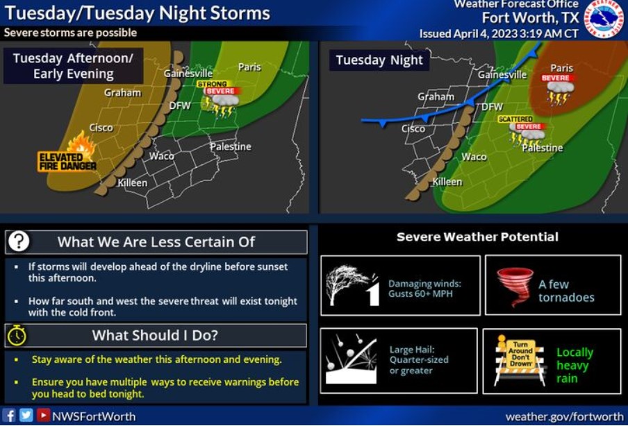
Expect severe storms again late this afternoon and tonight. Another dry, hot, and breezy day will result in elevated fire danger west of I-35 behind a dryline. Ahead of the dryline, a few storms may develop before sunset this evening. If thunderstorms can grow, they could become vital to severe. However, better chances for strong to severe storms will arrive with a cold front later tonight. The best potential for severe storms will be east of Highway 75 and north of I-20. How far south and west the severe threat will exist is still uncertain. All modes of severe weather will be possible. Pay attention to the weather Tuesday afternoon and evening, and have multiple ways to receive warnings before heading to bed Tuesday night!
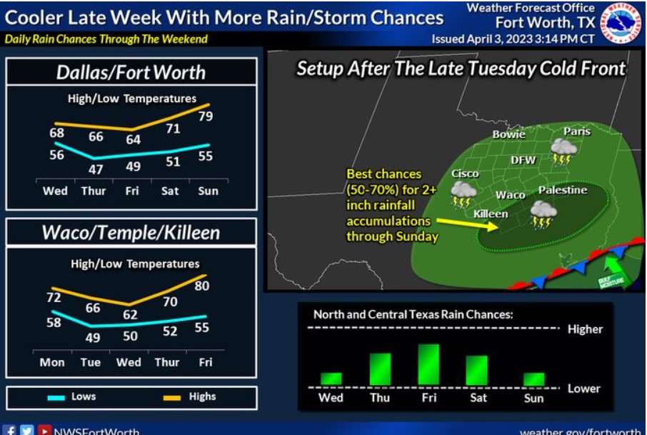
Following Tuesday’s cold front, showers and thunderstorms will continue to be possible each day, with the best chances expected in Central Texas each day. Temperatures will be well below the average late week, with highs generally in the 60s and lows in the 40s and 50s. Near to slightly above average temperatures return this weekend, with highs in the mid-70s to low 80s by Sunday.
Today and Tonight
Thunderstorm chances increase this evening and tonight, primarily along and east of the I-35 corridor. All modes of severe weather will be possible.
Elevated fire weather conditions are expected west of I-35 this afternoon.
Wednesday through Monday
Isolated thunderstorms will be possible along and south of I-20 on Thursday and Friday. Expect elevated fire weather conditions west of I-35 each afternoon through Thursday.
SPOTTER INFORMATION STATEMENT
Do not expect spotter activation at this time.
South Central and Southwest Arkansas, North Central and Northwest Louisiana, Southeast Oklahoma, and East and Northeast Texas
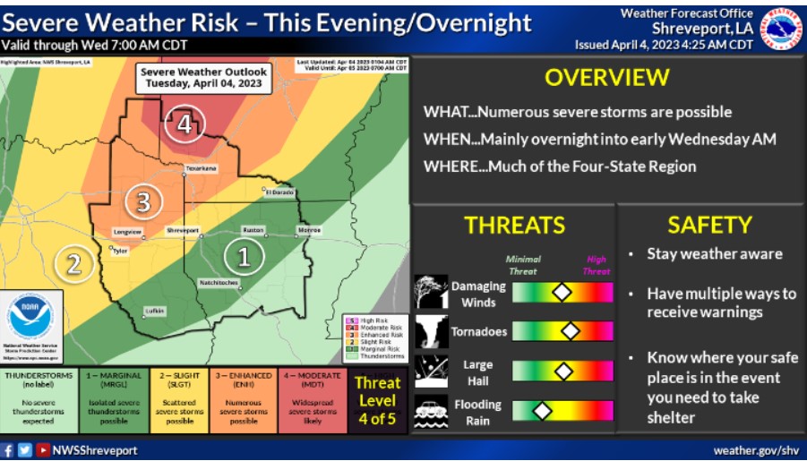
Another round of severe weather will be on the table for this Tuesday. Numerous severe storms, with all possible hazards, will move across portions of Northeast Texas, Southeast Oklahoma, and Western Arkansas Tuesday afternoon and evening and across much of the Four State Region early Wednesday morning.
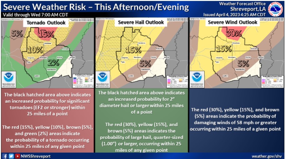
These are the probabilities for tornadoes, some of which may be strong, severe hail, quarter size or larger, and severe wind gusts, 58 mph or greater, Tuesday afternoon through early Wednesday morning.
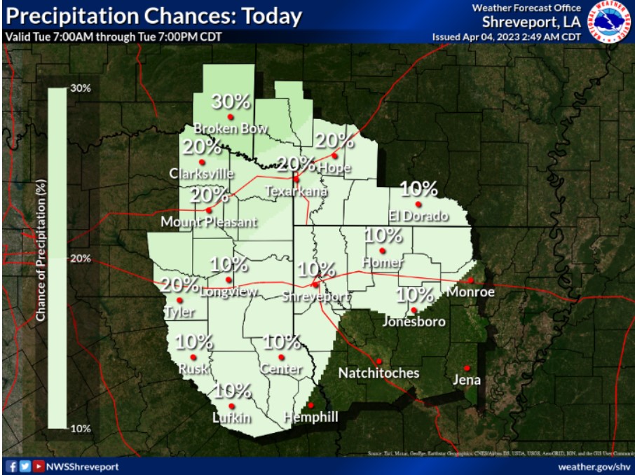
Cap will hold in place this afternoon, limiting rain chances through the afternoon. However, rain chances increase this evening and overnight.
Tuesday through Sunday.
Another round of strong to severe thunderstorms will be possible by Tuesday into Tuesday night as the next cold front will arrive. The severe threat is highest along and north of the I-30 corridor, where all modes of severe weather will be possible through the early morning hours on Wednesday.
The pattern looks to remain unsettled through the end of the week as rounds of heavy rainfall will become more likely as the front stalls south of the region. It could reintroduce flooding concerns across the region through the end of the week as several inches of rainfall may be possible over the next week. However, the rain will gradually diminish over the Easter weekend as the stalled boundary finally exits to the southeast.
SPOTTER INFORMATION STATEMENT
Do not expect spotter activation at this time.