


North and Central Texas
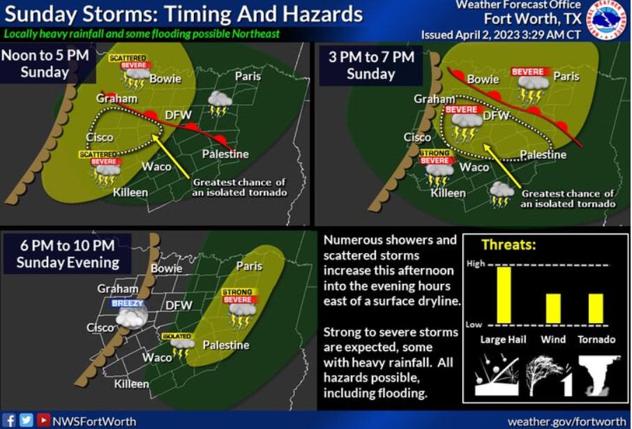
Showers and thunderstorms will develop across western North and Central Texas by midday today, then overspread the area from east to west during the afternoon before shifting across mainly the East Texas counties this evening. The severe weather threat will increase this afternoon and early evening as a warm front lifts north just ahead of a dryline entering far western sections of the region. Though giant hail is the primary threat, all modes of severe weather will be possible near the warm front back toward its intersection with the dryline. It includes a few tornadoes and damaging winds to 65 mph just south of the warm front. Stay weather aware and have multiple ways to receive warnings later today!
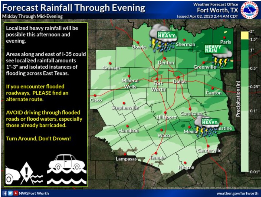
Though the primary concern with our progressive storm late today is severe weather, a few East Texas areas, especially north of I-20, could see localized rainfall between one and three inches, resulting in isolated flooding. Remember, avoid entering flooded roadways and choose an alternate route. Then, turn around, don’t drown! It could save your life.
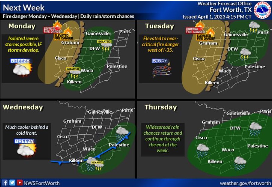
The first week of April will feature above-normal temperatures, rain, storm chances, and a threat of grassfires. Afternoon temperatures will climb into the 80s and 90s early next week, making it feel more like summer than spring. Showers and thunderstorms will be possible each day, with the best chances expected late next week. Additional anomalously warm, dry, and windy conditions behind a dryline will result in an elevated to near critical fire threat generally west of I-35 early to mid-week.
Today and Tonight
There is a chance of thunderstorms across the entire region this afternoon through tonight, with the best cases generally along and near the I-20 corridor. Expect scattered thunderstorms with a risk for giant hail, though all modes of severe weather are possible through nightfall.
Monday through Saturday
Rain and storm chances return by Monday afternoon and remain in the forecast through the week. A few intense storms with hail and gusty winds will occur periodically throughout the week.
Elevated to near-critical fire weather conditions are expected Monday, Tuesday, and Wednesday, mainly west of I-35.
SPOTTER INFORMATION STATEMENT
The NWS could request limited spotter activation north of I-20 this
afternoon and this evening.
South Central and Southwest Arkansas, North Central and Northwest Louisiana, Southeast Oklahoma, and East and Northeast Texas
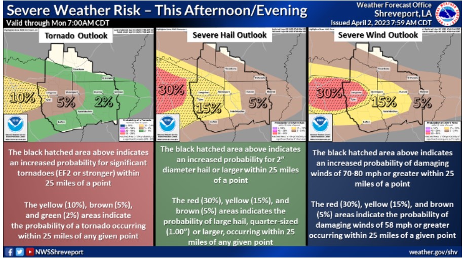
This graphic indicates the probabilities for tornadoes, large hail, and damaging regional winds. In addition, these probabilities indicate the potential for each threat to occur within 25 miles of any given point.
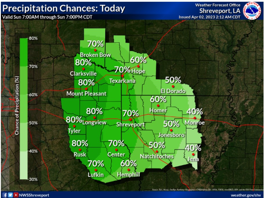
Showers and thunderstorms will increase from west to east across the region Sunday afternoon and night ahead of an upper-level disturbance.
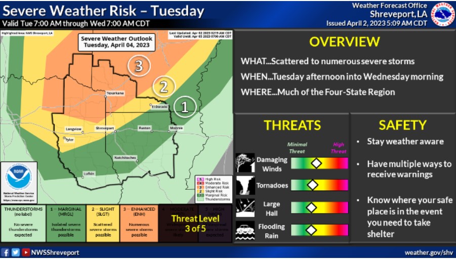
Another round of severe weather will be on the table for this Tuesday. Scattered to numerous severe storms with all possible hazards will move across the Four State Region Tuesday afternoon and evening into Wednesday morning. Stay tuned to the forecast, as changes are likely.
Today and tonight
Thunderstorms will return to the region this afternoon through this evening, some possibly vital to severe, with the primary threat of large hail up to golf ball size. Damaging wind gusts and tornadoes also cannot be ruled out with these storms as a returning warm front will allow for greater instability and shear, especially south of the I-20 corridor.
Monday through Saturday
Another round of strong to severe thunderstorms will be possible by late Tuesday into Tuesday night, as the next cold front, will arrive. The threat appears to be highest along and north of the I-30 corridor where all modes of severe weather will be possible through the early morning hours on Wednesday.
The pattern looks to remain unsettled through the end of the week as rounds of heavy rainfall will become more likely as the front stalls South of the region. It could reintroduce flooding concerns across the area through the end of the week as several inches of rainfall may be possible over the next week.
SPOTTER INFORMATION STATEMENT
Spotter activation will likely be needed this afternoon and evening.