


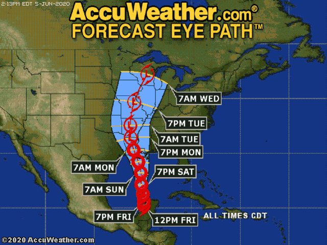
Tropical Storm Cristobal is currently moving northward along the coast of the northwestern Yucatan Peninsula. On its current path, Cristobal will move back out over the warm waters of the Gulf of Mexico near the northwest coast of the Yucatan Peninsula this evening.
Cristobal should track northward toward the Louisiana coast and intensify further this weekend. A combination of dry air and increased wind shear will limit just how strong Cristobal can intensify. The northward moving and strengthening tropical storm will bring the northern and eastern Gulf Coast heavy rainfall, potentially life-threatening storm surge, and localized strongly to perhaps damaging winds Sunday into early Monday. There is the potential for isolated tornadoes to the east and north of where Cristobal makes landfall late Sunday and Sunday evening. The more torrential rain will continue to spread inland over much of the Deep western South early next week.
Onshore winds over the west coast of Florida will increase coastal flooding starting as early as Saturday. A storm surge of 1-3 feet can be expected from Marco Island northward to Aripeka, including Tampa Bay. Winds will help bring a life-threatening storm surge elsewhere along the northern Gulf coast. Expected peak storm surge values include 2-4 feet from Grand Isle to Ocean Springs, including Lake Borgne, 2-4 feet from Indian Pass to Aripeka, and 1-3 feet from Ocean Springs to Indian Pass, including Mobile Bay and Pensacola Bay.
Rainfall totals of 2-4 inches will cover a large part of Florida and parts of the deep southwestward to western Louisiana and Arkansas. The highest rainfall totals of 6-12 inches will occur near and to the east and north of Cristobal tracks inland, mostly over eastern and southeastern Louisiana and southernmost Mississippi. An AccuWeather Local StormMax™ of 16 inches is forecast within this higher rainfall area.
All residents and interests from along the upper Texas coast eastward along and near the coast of Louisiana to the westernmost part of the Florida Panhandle should closely monitor this tropical cyclone’s movement. People in parts of this coastal area might need to take action, including enacting their hurricane plan late this week and this coming weekend.
Heavy rain will continue to diminish over the Yucatan Peninsula and Central America through the day Friday and Friday night as Cristobal tracks northward. The heavy rainfall will cause life-threatening flash flooding and higher-terrain mudslides.
Elsewhere in the basin, there are no other organized tropical systems, and none are expected to develop through the end of the week and probably through at least early next week.