


North and Central Texas
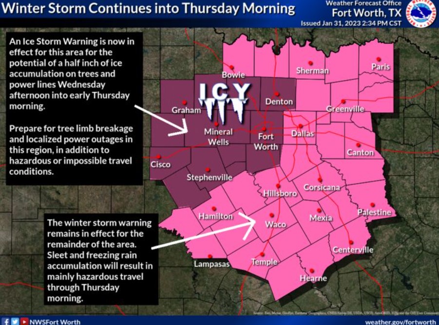
An ice storm warning is now in effect for I-35W and westward. It is for a half inch of ice accumulation Wednesday afternoon into early Thursday resulting in tree breakage and localized power outages in addition to hazardous or impossible travel conditions. In addition, a winter storm warning continues elsewhere in North and Central Texas for persisting freezing rain and sleet, leading to dangerous travel.
WINTER STORM WARNING REMAINS IN EFFECT UNTIL 6:00 THURSDAY MORNING
WHAT – Expect mixed precipitation, primarily in freezing rain or sleet, with the total accumulation of ice or sleet around a one-quarter inch. Bursts of sleet may total half an inch in some locations.
WHERE – North and Central Texas
WHEN – Until 6:00 Thursday morning
IMPACTS – Dangerous travel conditions will continue into early Thursday morning, with roads becoming nearly impassible in some areas later today. In addition, bridges and overpasses will remain icy.
PRECAUTIONARY/PREPAREDNESS ACTIONS
If you must travel, slow down and use extreme caution, particularly when approaching bridges and overpasses. Keep an extra flashlight, food, and water in your vehicle for an emergency.
You can find the latest road conditions for Texas at drivetexas.org.
Tonight.
Periods of light freezing rain, freezing drizzle, and sleet are possible through the evening, with freezing rain becoming more likely overnight. Since temperatures will stay at or below freezing through tonight, hazardous road conditions will remain. Please avoid travel unless unecessary.
Wednesday through Monday
Expect additional rounds of freezing rain and sleet Wednesday and Wednesday night. Ice accumulation will keep the road conditions hazardous through Wednesday night or possibly Thursday morning.
SPOTTER INFORMATION STATEMENT
Do not expect spotter activation at this time.
South Central and Southwest Arkansas, North Central and Northwest Louisiana, Southeast Oklahoma, and East and Northeast Texas
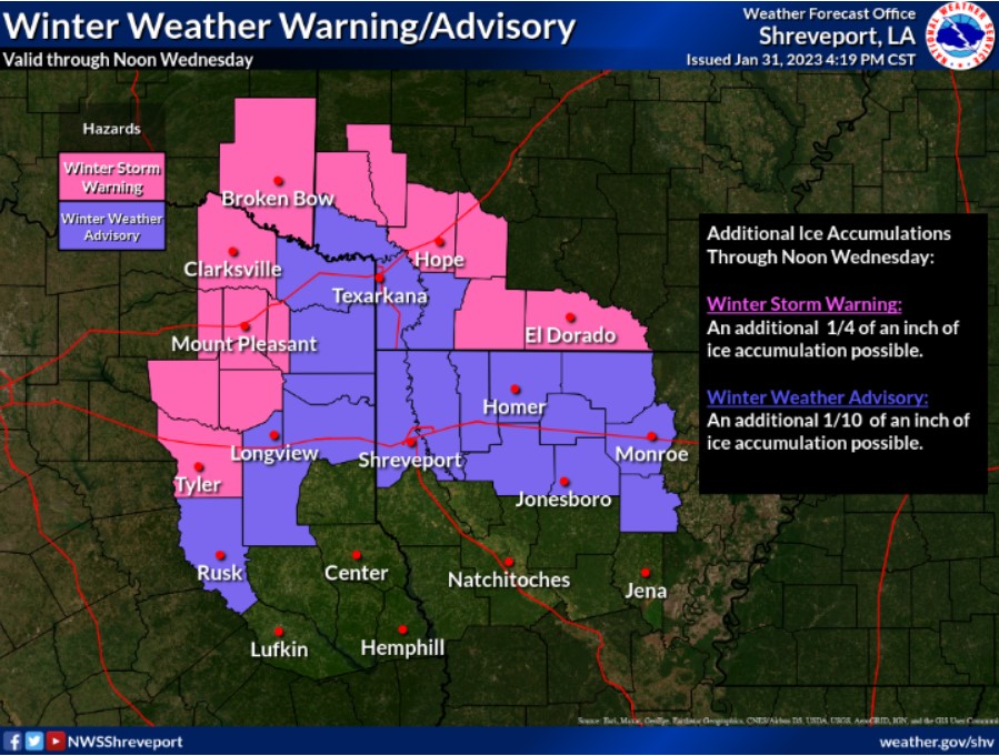
Look for possible significant ice accumulation across portions of Northeast Texas, Southeast Oklahoma, and Southwest Arkansas and lesser amounts across parts of extreme Northeast Texas and Southwest Arkansas through Wednesday Morning.
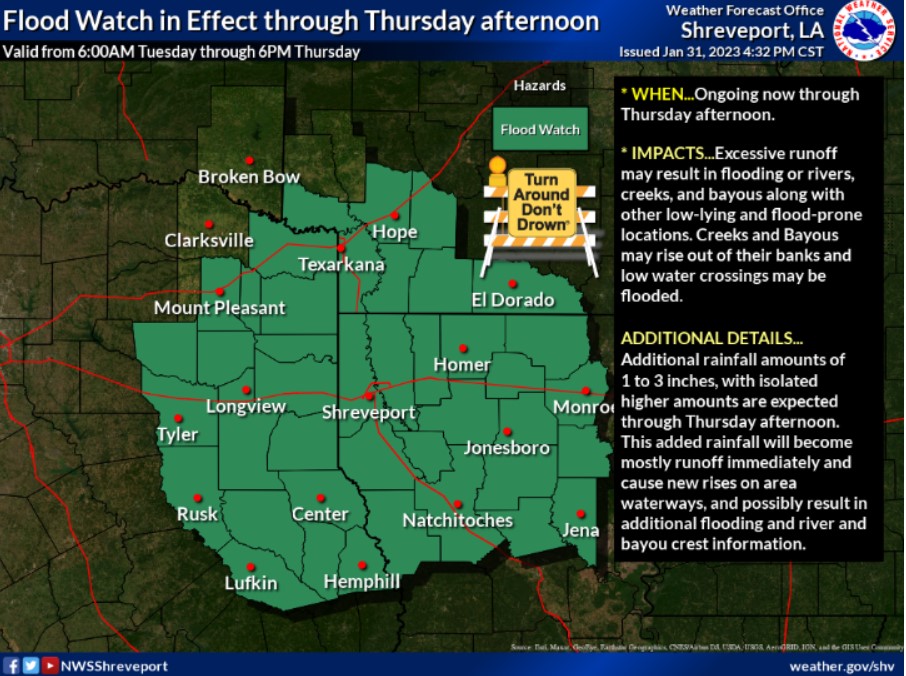
A Flood Watch is in effect for Northwest Louisiana, much of East Texas, and southwest Arkansas until 6:00 pm Thursday. It is because an additional one to three inches of rainfall can lead to flooding area waterways.
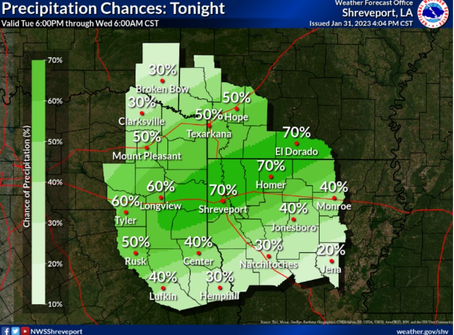
Scattered to numerous showers will continue across the entire Four State Region. Some of this could fall as freezing rain across portions of Northeast Texas, Southeast Oklahoma, Northwest Louisiana, and Southwest Arkansas.
Overnight low temperatures will fall to near or below freezing across much of the region tonight.
A WINTER STORM WARNING IS NOW IN EFFECT UNTIL NOON WEDNESDAY
WHAT – Expect significant icing with additional ice accumulations of nearly one-quarter an inch through late Wednesday morning.
WHERE – Sevier, Howard, Hempstead, and Nevada Counties.
WHEN – Until noon Wednesday.
IMPACTS – Bridges and overpasses could become slick resulting
in travel impacts this morning. Those impacts will continue
through the day and especially into the overnight hours. In addition, power outages and tree damage are likely due to the ice.
PRECAUTIONARY/PREPAREDNESS ACTIONS
If you must travel, keep an extra flashlight, food, and water in your vehicle in case of an emergency. Prepare for possible power outages.
The latest road conditions for the state you are calling from can be obtained by calling 5 1 1.
A FLOOD WATCH IS NOW IN EFFECT THROUGH THURSDAY AFTERNOON
WHAT – Flooding caused by excessive rainfall continues to be possible.
WHERE – Portions of Arkansas, Louisiana, and Texas, including the following counties and parishes in Arkansas, Columbia, Hempstead, Lafayette, Little River, Miller, Nevada, and Union. In Louisiana, Bienville, Bossier, Caddo, Caldwell, Claiborne, De Soto, Grant, Jackson, La Salle, Lincoln, Natchitoches, Ouachita, Red River, Sabine, Union, Webster and Winn. In Texas, Angelina, Bowie, Camp, Cass, Cherokee, Gregg, Harrison, Marion, Morris, Nacogdoches, Panola, Rusk, Sabine, San Augustine, Shelby, Smith, Titus, Upshur and Wood.
WHEN – Through Thursday afternoon.
IMPACTS – Excessive runoff may result in flooding rivers, creeks, streams, and other low-lying and flood-prone locations. Creeks and streams may rise out of their banks and flood low-water crossings.
ADDITIONAL DETAILS
Areas of rain will continue developing this afternoon through Thursday while spreading across much of the Four State Region. The higher rain rates will likely begin on Wednesday afternoon and persist through Thursday. Grounds remain very saturated in the wake of extensive heavy rains that have fallen over the last week, with many creeks, bayous, and lakes rising to near or over the flood stage.
Expect additional rainfall amounts of one to three inches over the Watch area through Thursday afternoon. This additional rainfall will quickly run off and generate new rises on area waterways, possibly resulting in further flooding.
– http://www.weather.gov/safety/flood
PRECAUTIONARY/PREPAREDNESS ACTIONS
You should monitor later forecasts and be alert for possible Flood Warnings. If you live in areas prone to flooding, you should be prepared to take action should flooding develop.