


North and Central Texas
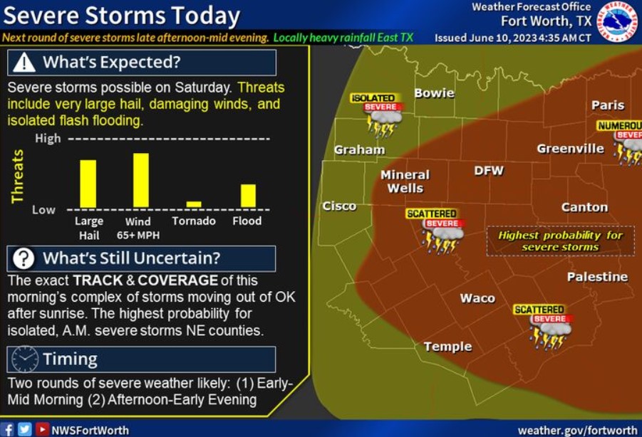
Severe thunderstorms are possible across North and Central Texas today. A complex of strong to severe storms will likely impact eastern portions of North Texas this morning before re-developing near and south of I-20 around mid-afternoon. The second round will probably be the more impactful round of storms with primary hazards, including large to giant hail, damaging winds to 70 mph+, frequent lightning strikes, and localized heavy rainfall with isolated instances of flooding or flash flooding across the East. Check back frequently for forecast updates, and keep a close eye on the sky, especially if you have outdoor plans!
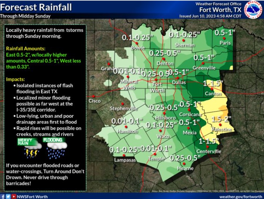
Two rounds of strong to severe storms containing heavy rainfall will be possible across our East Texas counties where 1 “-2,” with isolated, more serious amounts will be possible. Where training and heavier rains occur, flooding will be possible.
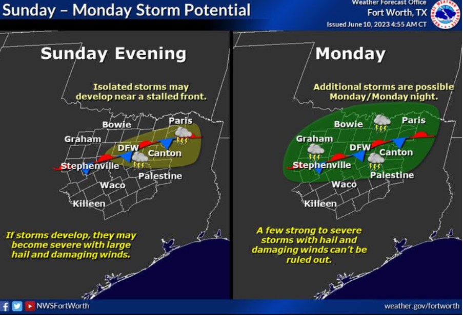
A weak cold front will stall across North Texas Sunday evening and may serve as a focus for isolated thunderstorm development. Storms may become severe if they develop. Additional thunderstorms are possible Monday through Monday night. A few strong to severe thunderstorms with hail and damaging winds can’t be ruled out, especially near and south of the lingering stalled front.
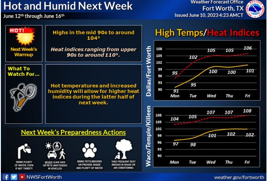
Expect hotter weather next week! Afternoon temperatures will climb into the mid-90s to nearly 104 degrees, with heat index values reaching 100-110 degrees across the region. Take all necessary precautions to avoid heat-related illnesses. Drink plenty of water, take frequent breaks in the A/C, and avoid spending time outdoors during the hottest part of the day.
Today and Tonight
A complex of storms may cross the Red River early this morning, with additional thunderstorm chances this afternoon and evening across most of North and Central Texas. Severe weather is possible, with the primary threats being large hail and damaging wind gusts.
Sunday through Friday
Thunderstorms may linger across Northeast Texas into Sunday morning.
Low, intermittent thunderstorm chances will continue Sunday evening through early Wednesday, primarily along and north of the I-20 corridor. You can not rule out severe weather.
Heat index values will approach 105 degrees Sunday afternoon. Expect a Heat Advisory criteria later in the upcoming week.
SPOTTER INFORMATION STATEMENT
Do not expect spotter activation at this time.
South Central and Southwest Arkansas, North Central and Northwest Louisiana, Southeast Oklahoma, and East and Northeast Texas
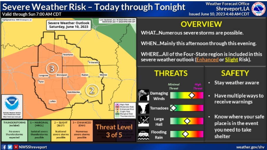
The threat of strong to severe thunderstorms continues today and tonight, with an Enhanced Risk for much of the Four-State region. A Slight Risk remains for the remainder of the area. Damaging wind gusts and large hail will be the primary threats, in addition to heavy rainfall that could result in localized flash flooding.
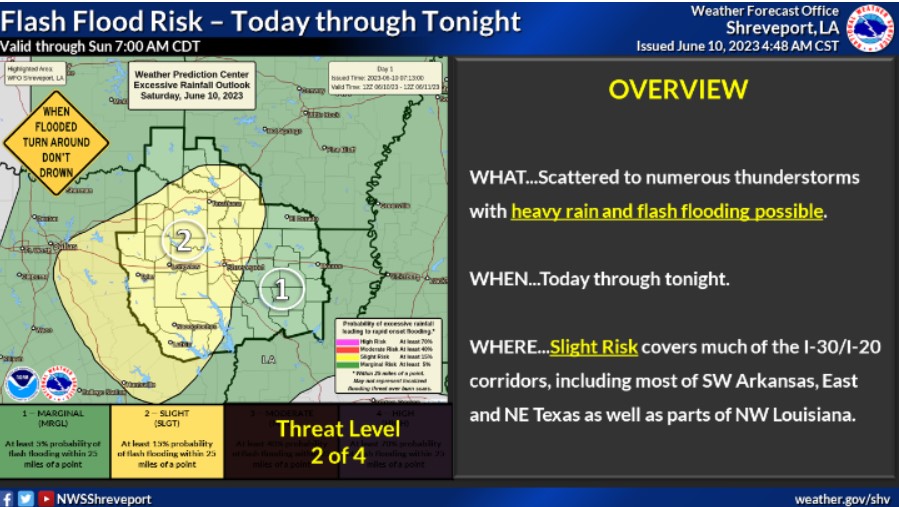
Heavy rainfall and flash flooding will be possible today and tonight as numerous strong to severe thunderstorms could affect the region. Expect 1-2 inches of rainfall occurring in some areas, mainly in the Slight Risk area, with isolated higher amounts possible.
Today and tonight.
Strong to severe thunderstorms have higher chances of returning today as a more substantial disturbance moves through the region. Damaging winds will be the greatest threat, but you can’t rule out large hail. Heavy rain from these thunderstorms can boost the potential for a flash flooding threat through tonight.
Sunday through Friday
Another round of damaging wind gusts will be possible on Sunday as a cold front moves into the region. Showers and thunderstorms remain in the forecast for portions of the area each of the following days
until late next week, along with some of the warmest temperatures of the year. Afternoon highs could approach the mid to upper 90s by the middle of next week.
SPOTTER INFORMATION STATEMENT
Do not expect spotter activation at this time.