


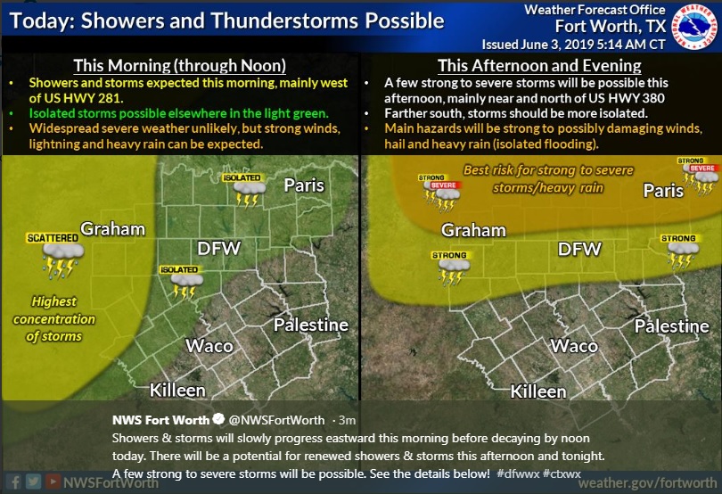
Showers & storms will slowly progress eastward this morning before decaying by noon today. There will be a potential for renewed showers and thunderstorms this afternoon and tonight. A few strong to severe storms will be possible.
A weakening line of thunderstorms will move east and continue weakening as moves toward the US 281 corridor through mid-morning. Severe weather is not expected, but gusty winds above 40 mph and isolated instances of pea size hail cannot be ruled out across this area.
There is a chance of thunderstorms beginning around midday and continuing through early to mid-evening along and north of Interstate 20. Best opportunities are expected near the Red River Valley and east of Interstate 35. A few storms may become strong to severe with very gusty downburst winds, hail, and frequent lightning due to high instability in the atmosphere. Also, localized heavy downpours may lead to isolated instances of flooding due to saturated ground across much of the area.
A slight chance of thunderstorms will linger overnight near the immediate Red River Valley and areas west of US 281. Severe weather is not anticipated, but a few intense storms with gusty winds are possible.
This Hazardous Weather Outlook is for portions of South Central Arkansas, Southwest Arkansas, North Central Louisiana, Northwest Louisiana, Southeast Oklahoma, East Texas, and Northeast Texas.
Scattered showers and thunderstorms will be possible today, mainly during the afternoon and evening hours. Organized severe weather is not anticipated, but a few isolated severe storms posing a damaging wind or hail threat cannot be ruled out.
SPOTTER INFORMATION STATEMENT
Limited spotter activation may be requested this afternoon and
evening north of Interstate 20.