


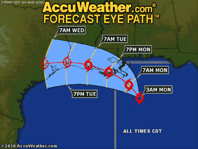
Marco is now a tropical storm about 115 miles to the south-southeast of the Mississippi River’s mouth. Landfall is expected along the Louisiana coast late this afternoon or evening as a tropical storm. A storm surge of 3-6 feet can occur along the coast, especially near and to the east of where Marco moves inland. Heavy rain and strong winds will also occur across southeastern Louisiana and southern Mississippi. Rainfall totals of 4-8 inches with an AccuWeather Local StormMax™ of 12 inches will result in flooding. Wind gusts of 60-70 mph with an AccuWeather Local StormMax™ of 80 mph will cause power outages and tree damage, especially near and east of where Marco moves over land. As a result of the wind and rain, Marco will be a one on the AccuWeather RealImpact™ Scale for Hurricanes in the United States. The AccuWeather RealImpact™ Scale for Hurricanes is a six-point scale with ratings of less than one and one to five.
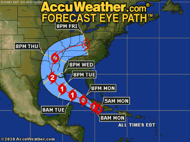
Meanwhile, Tropical Storm Laura will track just off the southern coast of Cuba today before emerging into the southeastern Gulf of Mexico later today and tonight. Laura will continue in a general northwestward motion on Tuesday and Wednesday, tracking through the central Gulf of Mexico, where the storm will likely strengthen into a hurricane before making landfall over southern Louisiana later Wednesday or Wednesday night.
Heavy rain and gusty winds will continue to impact Cuba, Jamaica, and the Cayman Islands today. Wind gusts of 50-60 mph with an AccuWeather Local StormMax™ wind gust of 70 mph can occur near the path of Laura. These winds will be capable of producing power outages and some minor damage to weak structures and trees. In addition to the wind, 4-8 inches of rain with an AccuWeather Local StormMax™ of 12 inches will fall, resulting in some flooding, especially over the higher elevations and in low-lying and poor drainage areas. Due to rain and wind impacts, Laura will be a one on the AccuWeather RealImpact™ Scale for Hurricanes in Cuba.
As Laura moves through the central Gulf of Mexico, the storm will strengthen into a hurricane. Given the warm waters and relatively light wind shear expected in Laura’s path, there is some concern that Laura could increase rapidly during the day Tuesday and become a major hurricane.
As Laura approaches coastal Louisiana, damaging winds and flooding rainfall will be likely. The most massive rainfall totals will be close to the path of the center of circulation. It will go over Southern Louisiana, where sums of 4-8 inches and an AccuWeather Local StormMax™ of 12 inches will fall. Damaging winds are also likely with Laura as it moves inland. There will be wind gusts between 80-100 mph and an AccuWeather Local StormMax™ wind gust of 130 mph from Laura as the storm makes landfall on the Louisiana coast. It will likely further exacerbate the wind and rain damage situation in areas that had already been affected by Marco. As a result of the wind and rain impacts, Laura will be a two on the AccuWeather RealImpact™ Scale for Hurricanes in the United States.
Residents and interests in the central Gulf Coast states, chiefly Louisiana, need to prepare for significant impacts from Marco and Laura. Flooding in some areas may last for days, and many areas could be without power for multiple days, so your plans to take action need to be finalized today.
The rest of the Atlantic basin remains relatively quiet at this time, with no further development expected for the next five days.
By AccuWeather Senior Meteorologist Rob Miller