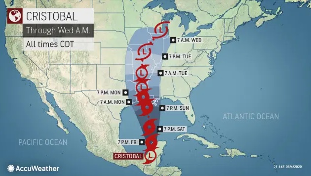
Cristobal was upgraded to a Tropical Storm at 1:00 pm Friday with 40 mph wind. Cristobal was on the move a day after the storm weakened to a depression and nearly crawled to a halt over southern Mexico. According to the National Hurricane Center, the depression was unleashing flooding rainfall on Friday morning as it headed north-northeast at seven mph and with 35-mph sustained winds. Forecasters expect the system to strengthen again over the Gulf of Mexico’s warm waters before striking the upper Gulf Coast of the United States late Sunday to early Monday.
The government in Mexico discontinued all tropical storm warnings that were in effect from Campeche to Coatzacoalcos, Mexico, as of 10:00 am CDT Thursday. The dangers of life-threatening flooding and mudslides will persist into Friday. Cristobal, which stalled over southeastern Mexico as predicted, dumped 14 inches of rain.
The storm will continue to move northward on Friday, eventually emerging into the Gulf of Mexico.
“We are forecasting Cristobal to make landfall over the central coast of Louisiana late Sunday or Sunday evening,” Dan Kottlowski, AccuWeather’s top hurricane expert, said.
Some shift in the storm track is possible, especially after it begins to move northward from Mexico this weekend due to how an area of high pressure, currently over the southern U.S., interacts with it.
There will be no impact on the United States at least through the end of the workweek. This weekend, Cristobal will be approaching the Gulf Coast anywhere from the upper Texas coast to the east near the Mississippi coast for landfall.


 EastTexasRadio.com Powered by Ten Stations


