


North and Central Texas
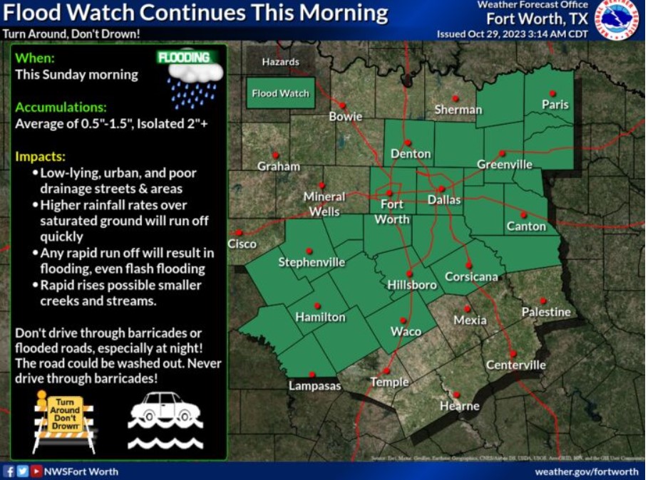
The Flood Watch remains in effect for the same areas through the morning hours. Previous heavy to isolated torrential rainfall in spots has led to antecedent soil conditions conducive for rapid run-off and flooding with any additional rounds of hefty rain.

Another round of widespread showers with a few thunderstorms will result in rainfall amounts between one quarter and one inch through mainly the morning hours. Isolated higher parts to two inches are possible. Soils across much of the region will remain saturated with higher rainfall rates, quickly running off and causing minor flooding of streets and typical low-lying, flood-prone areas. Isolated instances of flash flooding will also be possible.

Temperatures will fall to or below 32 degrees Monday night into Tuesday morning. If you’re under a Freeze Watch, prepare any outdoor vegetation to avoid damage due to the cold. Temperatures will likely fall below freezing around midnight and rise above freezing by 10:00 am.

A few more showers and isolated storms are expected today into early Monday. Locally heavy rainfall up to an inch or slightly higher this morning and again this evening will result in primarily minor flooding due to saturated soils. Isolated amounts between one to two inches could result in flash flooding. Wet, blustery/windy, and chilly weather is expected today into tonight. Bundle up, and remember to wear layers! Also, turn around and don’t drown if you see flooded roads or low-lying areas. Do not drive around barricades. It could save your life.
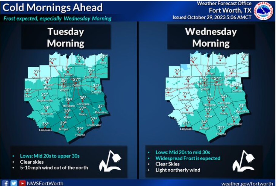
Tuesday and Wednesday morning temperatures will be pretty cold, with most locations experiencing their first freeze of the season. Frost is likely. Therefore, make sure to protect any sensitive outdoor vegetation.
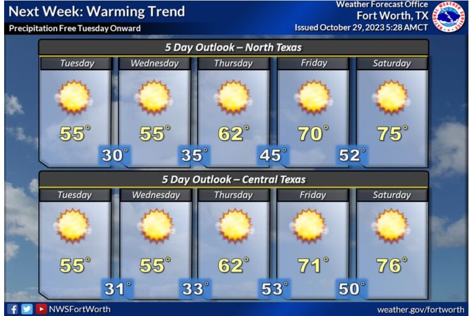
The forecast from Tuesday onward will look dry, with temperatures increasing from the mid-50s on Tuesday to mid-70s on Saturday. Early morning frost is likely Wednesday and Thursday morning.
Today and Tonight
Brief periods of heavy rain may lead to minor flooding and isolated flash flooding this morning. You can not rule out an isolated storm or two this afternoon/tonight. Do not expect severe weather.
Monday through Saturday
Early season freezing temperatures will be possible Tuesday through Thursday. Even where temperatures remain above freezing, overnight and early morning frost will occur.
SPOTTER INFORMATION STATEMENT
Do not expect spotter activation at this time.
South Central and Southwest Arkansas, North Central and Northwest Louisiana, Southeast Oklahoma, and East and Northeast Texas

High temperatures across the Four-State Region this afternoon will range from the upper 50s northwest to the mid and upper 80s southeast.
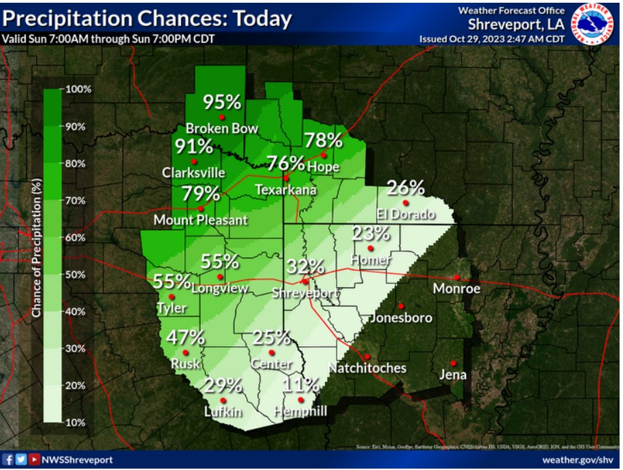
Rain with a few embedded thunderstorms will persist today across portions of Northeast Texas, Southeast Oklahoma, and Southwest Arkansas. Showers will become more isolated to widely scattered farther south across East Texas and North Louisiana.
Today and tonight
Showers with embedded thunderstorms will increase in coverage today across mainly Northeast Texas, Southeast Oklahoma, Southwest Arkansas and extreme Northwest Louisiana. Some of this rainfall could be locally heavy at times, with isolated flooding in low-lying areas
possible.
Monday through Saturday
Showers and embedded thunderstorms are to continue into Monday, with conditions improving from the north on Monday evening. Much colder temperatures expected through much of the work week with low temperatures at or slightly below freezing on Wednesday morning and Thursday morning.
SPOTTER INFORMATION STATEMENT
Do not expect spotter activation at this time.