


North and Central Texas

Fog is expected across much of the area this morning and possibly dense at times, especially across Central Texas. However, any fog should dissipate by midday, from partly sunny to mostly cloudy skies. Temperatures will warm into the mid-70s to low 80s this afternoon. Chances for showers and thunderstorms will increase late this evening. A few intense storms with hail may be possible across portions of North Texas late tonight into early Wednesday morning.
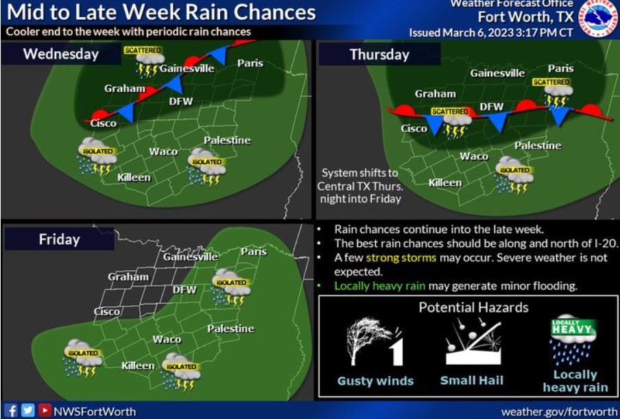
Rain chances arrive late Tuesday and will stick around for a few days associated with an upper-level disturbance and a slow-moving front. Some intense storms and locally heavy rain are possible but do not expect widespread severe weather and flooding. Rain will exit to the east late Thursday night into Friday.
Today and Tonight
Patchy fog this morning will support visibility below half a mile in some areas.
Thunderstorm chances increase this evening across Western North Texas and North Texas overnight. In addition, a few storms may produce small hail this evening.
Wednesday through Monday
Off and on thunderstorm chances continue through Thursday night. A few storms may be intense, with hail being the primary threat. Some thunderstorms may also produce heavy rain and localized minor flooding.
Thunderstorm chances return Saturday night and Sunday.
SPOTTER INFORMATION STATEMENT
The NWS does not expect spotter activation at this time.
South Central and Southwest Arkansas, North Central and Northwest Louisiana, Southeast Oklahoma, and East and Northeast Texas
Today and tonight
Isolated to scattered showers and thunderstorms will develop late tonight near and north of a weak cold front over portions of extreme Northeast Texas, Southeast Oklahoma, and adjacent sections of Southwest Arkansas. However, the threat of hazardous weather is low.
Wednesday through Monday
Scattered to numerous showers and a few thunderstorms will continue at times Wednesday through Friday morning across portions of extreme Northeast Texas, Southeast Oklahoma, and Southwest Arkansas. Thunderstorms are near and north of a weak frontal system that will remain stationary over the area. Heavy rainfall will be possible, with widespread rainfall amounts of one to two inches, with isolated higher amounts of up to three inches possible. It may result in minor flooding of low-lying, poor drainage areas before the rain diminishes Friday morning.
Additional isolated to scattered showers and a few thunderstorms will return to the area Saturday night and Sunday near another weak surface front before cooler and drier conditions, return to the area Monday.
SPOTTER INFORMATION STATEMENT
The NWS does not expect spotter activation at this time.