


This Hazardous Weather Outlook is for North and Central Texas.
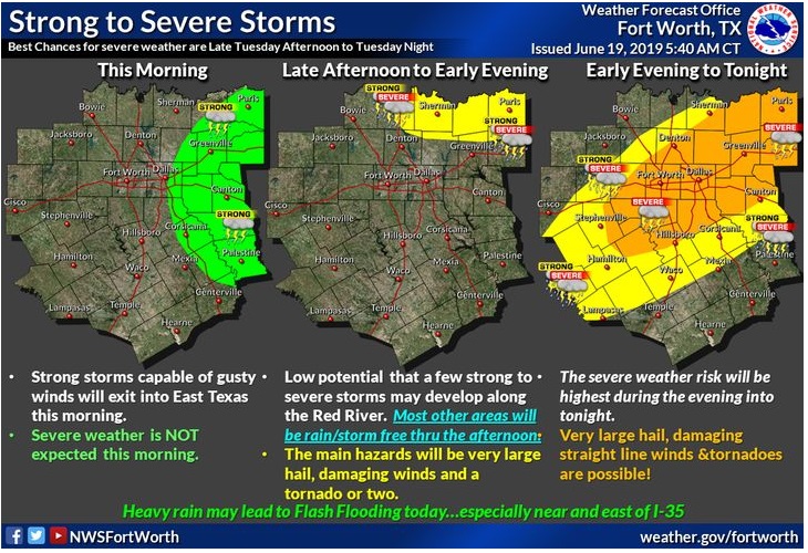
This afternoon, there will be a risk for strong to severe thunderstorms, especially for areas near and north of a Hamilton to a Canton line. The primary hazards will be very large hail and damaging to possibly destructive winds. There will also be a risk for tornadoes, namely for thunderstorms near any residual boundaries. Heavy rainfall may result in flooding of small creeks, streams, lakes, and rivers.
Very hot conditions are anticipated across Central Texas this afternoon with heat index values in the 105 to 110-degree range.
Tonight, the risk for strong to severe storms will shift into Central and East Texas. The main hazards will be large hail and damaging winds.
South Central Arkansas, Southwest Arkansas, North Central Louisiana, Northwest Louisiana, Southeast Oklahoma, East Texas, and Northeast Texas.
Thunderstorms are expected to increase today through tonight as an upper-level disturbance advances across the region. Some storms may be intense to severe with the threat of damaging winds, large hail, and an isolated tornado also cannot be ruled out. Locally heavy rainfall could also produce isolated flooding in some areas.
Thursday through Tuesday
Hot conditions are expected again on Thursday, especially across
Central Texas. Heat index values may climb to near or just above 105 degrees.
After a break in storm chances on Friday, more scattered thunderstorms are possible over the upcoming weekend.
Thunderstorms are expected to linger across North Louisiana and Southwest Arkansas through midday Thursday before diminishing by Thursday afternoon. Only isolated showers and thunderstorms are expected across portions of the region on Friday and Saturday before becoming more scattered by Sunday through early next week. Although severe weather is unlikely, a few intense storms may be possible from Sunday through early next week.
SPOTTER INFORMATION STATEMENT
Spotter activation will likely be requested over most of North and parts of Central Texas later today. Northeast Texas activation of emergency managers, spotter networks, and amateur radio operators should not be needed today or tonight.