


North and Central Texas

Scattered showers and storms will spread into the area from the west during the daytime. Do not expect severe weather. Highs will be in the mid-60s to low 70s with breezy south winds of 15-25 mph.
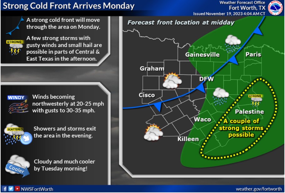
A strong cold front will move through the area on Monday. A few intense storms with gusty winds and small hail are possible in Central and East Texas, mainly during the afternoon. It will turn breezy and much more relaxed behind the front, with 20-25 mph northwest winds and higher gusts.

Behind a strong cold front early in the week, below-normal temperatures will continue through the end of Thanksgiving week. Highs will top out in the 50s and low 60s, with chilly mornings in the 30s and low 40s. Rain-free weather will prevail until our next strong cold front and storm system arrives next weekend.
Today and Tonight
There is a low potential for storms across North Texas today and tonight.
Monday through Saturday
Additional storms are possible near and east of I-35 on Monday. Do not expect severe weather, but a few showers, with small hail and gusty winds, could be intense.
SPOTTER INFORMATION STATEMENT
Do not expect spotter activation at this time.
South Central and Southwest Arkansas, North Central and Northwest Louisiana, Southeast Oklahoma, and East and Northeast Texas

On Monday, they closely monitor the threat of strong to severe storms as a Slight Risk is in place across much of the Four-State Region. All hazards of extreme weather are still being considered possible at this time. Stay tuned to the forecast through the weekend for the latest.

A mild to warm day across the Four State Region today, with afternoon high temperatures ranging from the upper 60s north to the lower and middle 70s south.

Look for rain chances to increase this afternoon across mainly the northern half of Northeast Texas, Southeast Oklahoma, and portions of Southwest Arkansas.
Today and tonight
Showers will increase across portions of the region late this afternoon and into the evening, with an isolated thunderstorm or two into the overnight. At this time, do not expect any severe weather today or tonight.
Monday through Saturday
As we move into Monday and especially Monday Evening and overnight, showers and thunderstorms will become numerous, and some organized severe weather will be possible. In addition, locally heavy rainfall
will be possible across portions of the region as well late Monday into Monday Night.
SPOTTER INFORMATION STATEMENT
Do not expect spotter activation at this time.