


North and Central Texas
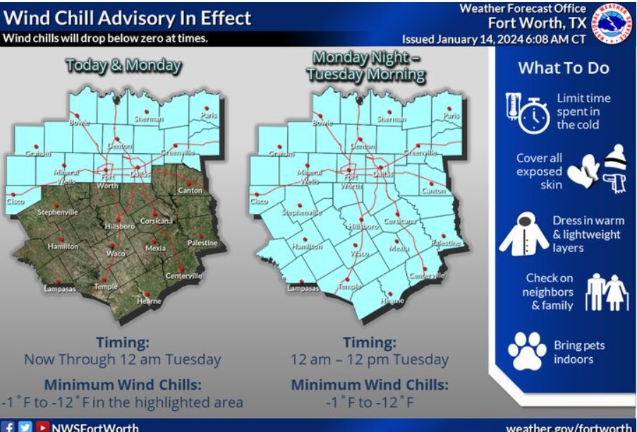
A Wind Chill Advisory is now in effect for portions of North Texas today and Monday. Expect minimum wind chills in the advisory area between 1 below zero and 12 below zero. The Wind Chill Advisory will expand to all regions Monday night through midday Tuesday. Expect minimum wind chills between 1 below zero and 12 below zero across the region.
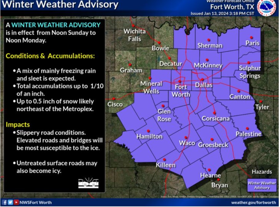
A Winter Weather Advisory is in place for most of North and Central Texas from noon Sunday to noon Monday. Expect a mix of mainly freezing rain and sleet in the advisory area. Expect a total accumulations of up to 0.10 inch. Additionally, up to a half-inch of snow is likely in some areas northeast of the Metroplex. Slippery road conditions are possible. While elevated roads and bridges will be the most susceptible to the ice, untreated surface roads may also become icy.
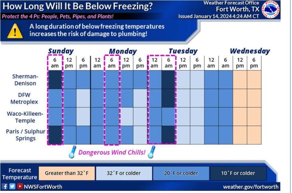
An Arctic blast has arrived, with dangerously cold temperatures continuing through the middle of next week. Temperatures will remain below freezing from today through Wednesday morning for nearly all of North and Central Texas. Protect exposed and vulnerable pipes by covering or wrapping them if you haven’t already done so, and drip your indoor faucets during the prolonged sub-freezing temperatures. Check on your loved ones and neighbors, and ensure all pets are indoors.
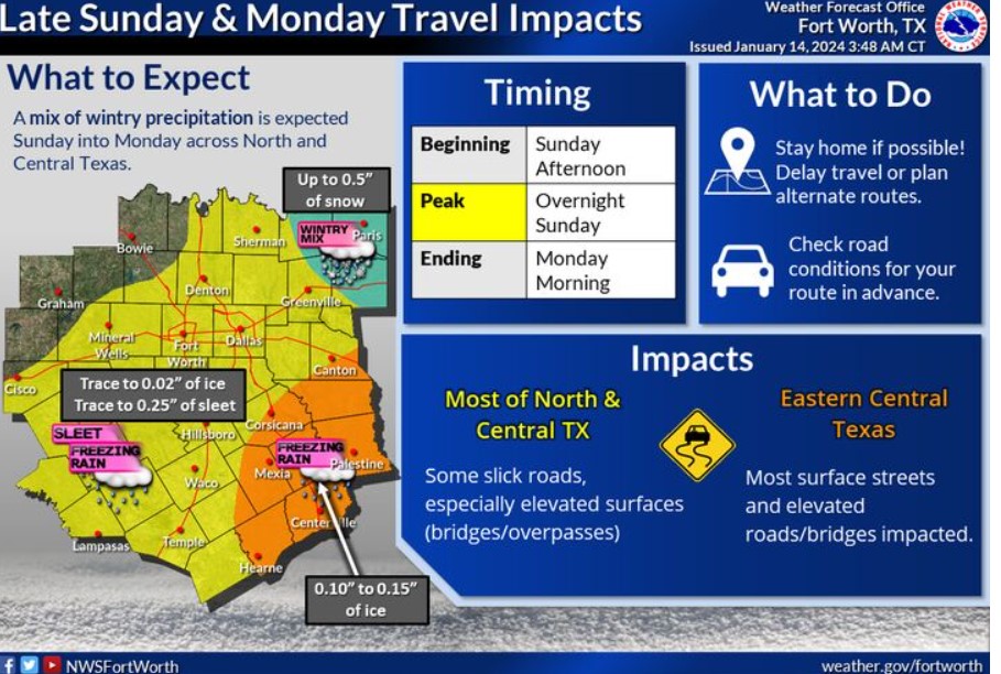
A mix of wintry precipitation is expected across North and Central Texas beginning today and ending Monday morning. Most regions will likely see between 0.01 and 0.10 inches of mainly freezing rain and sleet. Higher ice accumulations in Eastern Central Texas may impact most surface streets and elevated roads/bridges. There is a chance for snow in far Northeastern counties, including Paris, up to a half-inch.
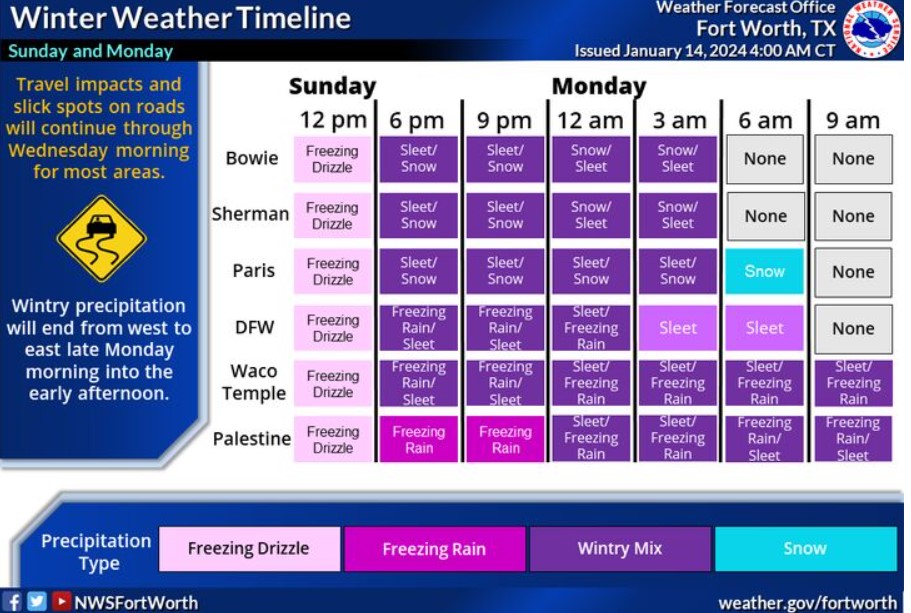
Winter precipitation will start today and continue through late Monday morning. The primary precipitation type throughout the region will be freezing rain or sleet. The main areas with a potential for snow will be along the Red River. The most significant impacts will be across Eastern Central Texas, where freezing rain accumulations will range between 0.10″ to 0.15.” Stay home if possible, as slick roads start this afternoon.
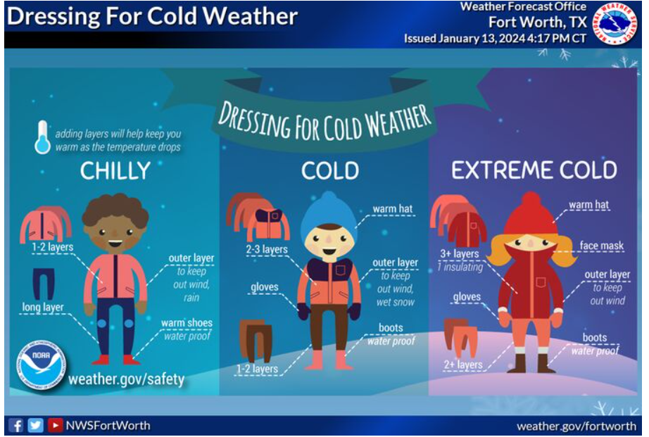
If you must venture outdoors over the next few days, cover exposed skin and dress in layers to reduce your risk of frostbite or hypothermia. Learn to protect yourself from the cold weather at weather.gov/safety/cold
Today and Tonight
Frigid temperatures have arrived, with wind chill values in the single digits five below zero. Protect any outdoor pipes and let indoor faucets drip during this prolonged period of sub-freezing temperatures.
Freezing rain and sleet are expected to begin this afternoon and will increase in coverage and intensity overnight into early Monday. Expect ice and sleet to accumulate on bridges, overpasses, and untreated surface roads, especially across Eastern Central Texas.
Monday through Saturday
Wintry precipitation will end Monday morning, but impacts will continue into Wednesday for many areas as temperatures remain below freezing. Some melting may be possible on Tuesday, but any lingering water will refreeze Tuesday night.
Frigid temperatures will continue through Wednesday morning. Wind chill values below zero are expected across the entire area Monday night into Tuesday morning. Low temperatures will be in the single digits to low teens Tuesday morning and in the teens Wednesday morning.
SPOTTER INFORMATION STATEMENT
Do not expect spotter activation at this time.
South Central and Southwest Arkansas, North Central and Northwest Louisiana, Southeast Oklahoma, and East and Northeast Texas
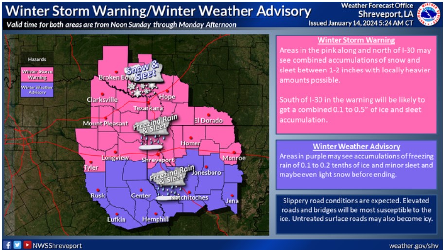
A Winter Storm Warning and a Winter Weather Advisory are now in effect through Monday afternoon. For our zones in pink along and north of I-20, sleet and snowfall accumulations of 1-2 inches are expected, with locally higher amounts possible. Areas between I-20 and I-30 could also see freezing rain and ice accumulations between a tenth and a quarter of an inch. The Winter Weather Advisory area south of I-20 will see freezing rain and sleet accumulations of 0.1 to 0.2 tenths of an inch.
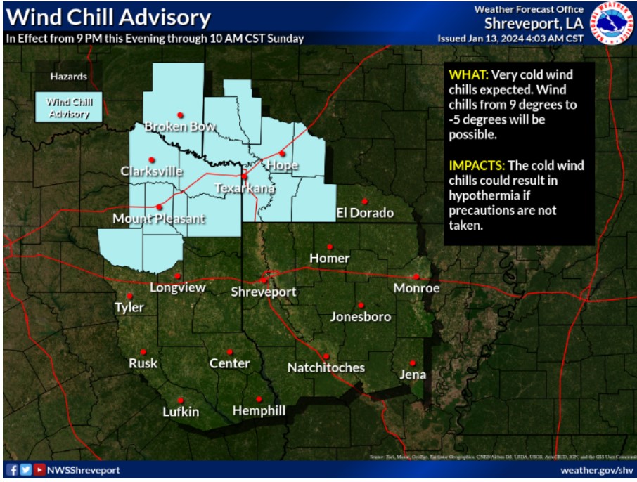
A Wind Chill Advisory continues through Noon on Sunday. Expect dangerous Wind Chill values from 9 degrees above to -5 degrees below zero for zones in light blue.
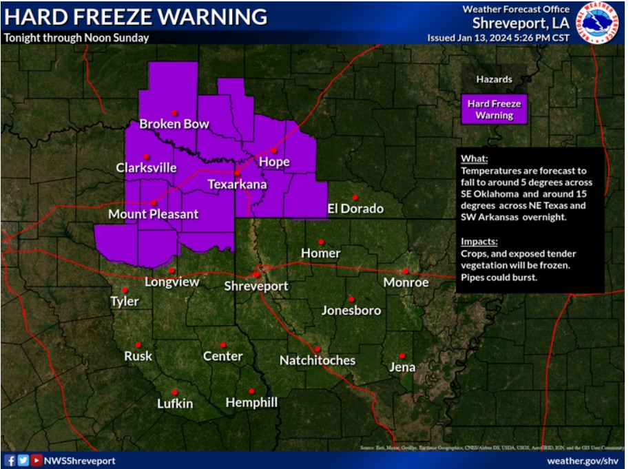
Overnight low temperatures are forecast to range from 5 to 15 degrees across much of the I-30 corridor. A Hard Freeze Warning is now in effect.
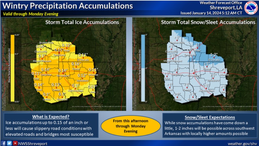
Areas between I-20 and I-30 could see freezing rain and ice accumulations between a tenth and a quarter of an inch. Locations south of I-20 could see between a tenth and two-tenths of an inch of ice. Most of these locations should see minor amounts, generally less than an inch, of snow/sleet. Farther north, in Southeast Oklahoma and Southwest Arkansas, 1 to 2 inches of sleet and snow are possible, with locally higher amounts.
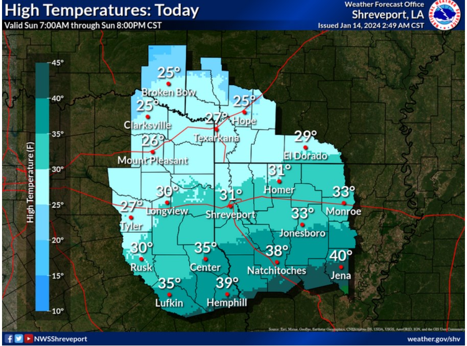
Increasing clouds will thicken and lower with frigid daytime high temperatures areawide.
SPOTTER INFORMATION STATEMENT
Do not expect spotter activation at this time.