


North and Central Texas

Increasing concerns for severe weather occur on Saturday, possibly in two separate rounds. A complex of strong to severe storms should impact our eastern North Texas and East Texas in the morning, re-developing mainly along and south of I-20 Saturday afternoon. The primary impacts will be damaging winds greater than 65 mph, significant to giant hail, frequent lightning strikes, and localized torrential rainfall across eastern areas with isolated instances of flooding or flash flooding. There is still some uncertainty in timing and evolution, as many features will be in play for storm development, especially east of the dryline by afternoon, as the position of the dryline and any outflow boundaries from morning storms, as well as cloud cover and temperatures will all play a role in severe storm development and coverage. Continue to check back frequently for the forecast regarding Saturday’s severe weather threat, especially if you have outdoor plans or for any planned significant outdoor events!

The first half of next week will be pretty toasty, with highs mainly in the 90s to around 100 degrees! High humidity will push heat indices even higher in the upper 90s to about 105. Make sure to practice heat safety and know the signs of heat illness!
Today and Tonight
Thunderstorms may impact portions of East Texas this afternoon. The severe weather threat is low.
Saturday through Thursday
An early morning complex of storms may cross the Red River on Saturday with additional thunderstorm chances later in the day. Some storms on Saturday could become severe, with damaging winds and large hail expected to be the primary threats.
Thunderstorms may accompany a cold front Sunday afternoon and evening across Northeast Texas.
A nocturnal complex of storms could impact portions of North Texas late Monday night into early Tuesday morning.
Hot and humid weather will prevail during the upcoming weekend. Heat index values may approach 105 degrees Sunday afternoon. We could reach a heat advisory criteria again Wednesday and Thursday.
SPOTTER INFORMATION STATEMENT
Do not expect spotter activation at this time.
South Central and Southwest Arkansas, North Central and Northwest Louisiana, Southeast Oklahoma, and East and Northeast Texas
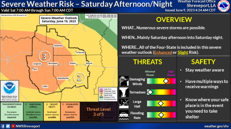
The National Weather Service has upgraded the risk for strong to severe thunderstorms to include an Enhanced Risk for much of the Four-State region on Saturday into Saturday night. There is a Slight Risk highlighted for the remainder of the area. Damaging wind gusts and large hail will be the primary threats, in addition to heavy rainfall that could result in flash flooding.
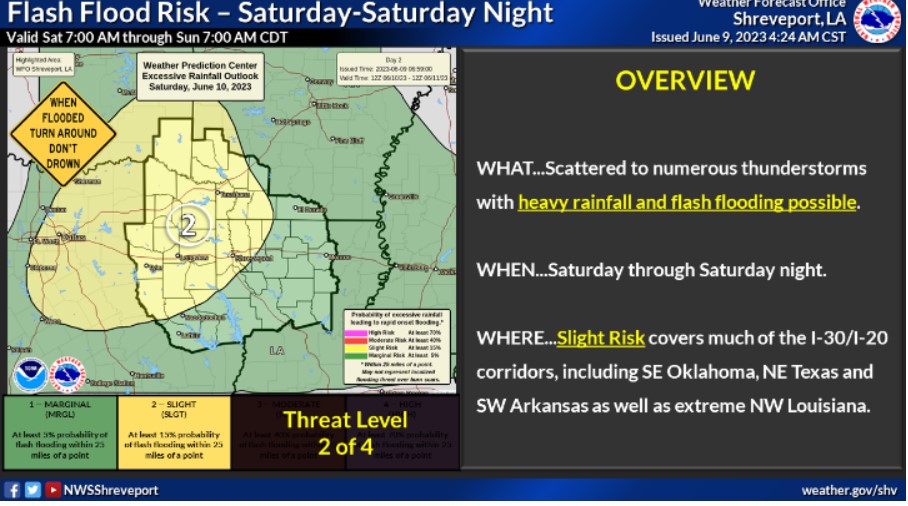
Heavy rainfall and flash flooding will be possible from Saturday through Saturday night, as you can expect strong to severe thunderstorms to affect the region. 1-3 inches of rainfall can occur in some areas, mainly in the Slight Risk area, with isolated higher amounts possible.

Isolated to widely scattered showers and thunderstorms are expected again this afternoon, mainly across the northern and eastern sections of the Four-State region.
This afternoon and tonight
Isolated to scattered showers and thunderstorms will be possible across the region this afternoon and evening. A few storms could produce small hail and some strong wind gusts.
Friday through Wednesday
The upper-level pattern over the region will continue to keep an unsettled weather theme through the rest of the week. Isolated strong thunderstorms may be possible each day, with gusty winds and brief heavy rainfall being the main threats with some storms. There will be a higher chance for severe thunderstorms on Saturday as a more substantial disturbance moves through the region.
SPOTTER INFORMATION STATEMENT
Do not expect spotter activation at this time.