


North and Central Texas

Severe thunderstorms may develop late Thursday across western North Texas, with more widespread showers and thunderstorms accompanying a cold front moving through the area later Thursday night into Friday. Potential hazards include large hail, damaging winds, and a couple of tornadoes, primarily north of I-20 and I-30.
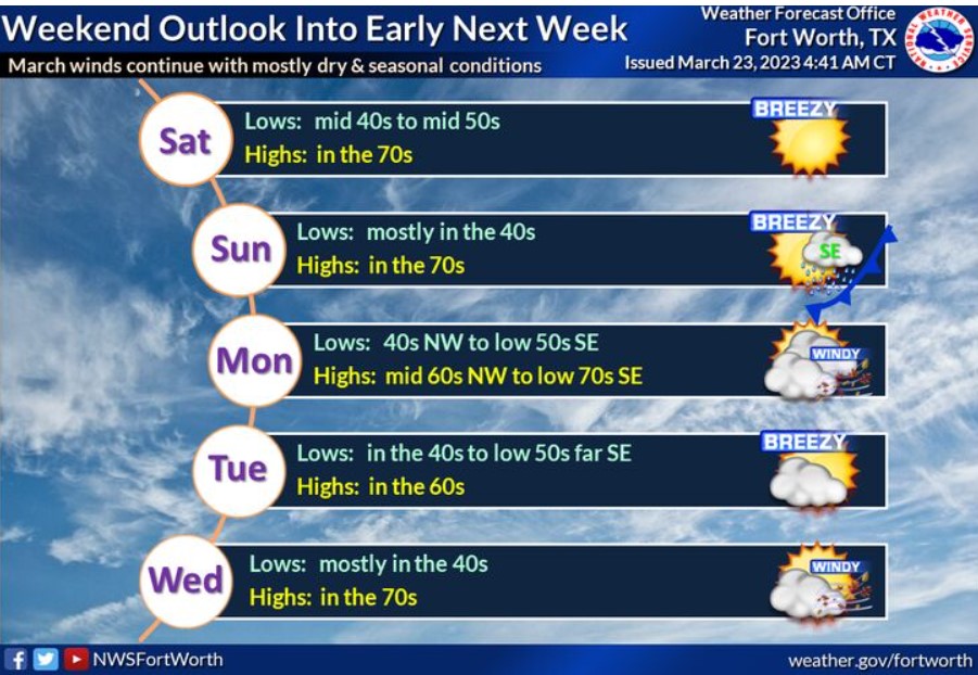
Saturday through Tuesday will start sunny and warm, with highs in the 70s. There will be a slight chance for showers and possibly an isolated storm across eastern Central Texas on Sunday but expect nothing significant or severe. A cold front moves south through the area later Sunday into Sunday night, with brisk and slightly cooler temperatures, though generally not far off from normals in late march.
Today and Tonight
Expect thunderstorms to develop late Thursday afternoon across northwest Texas along a dryline and move into far western North Texas this evening. Increasing storm coverage is expected overnight as storms push east through the area.
Large hail and damaging winds will be the main threats across much of North Texas into far western Central Texas. Giant hail and a tornado will be possible with any discrete severe storms later tonight.
Friday through Wednesday
A cold front will sweep across the region on Friday with a broken line of intense to severe storms along and ahead of the cooler air. Much of this activity will shift east of I-35 by early Friday afternoon. The cold front and extreme weather will move east of the area by early Friday evening.
SPOTTER INFORMATION STATEMENT
Spotter activation may be requested, especially by this evening
across the immediate Red River into the Big Country west of Highway
281.
South Central and Southwest Arkansas, North Central and Northwest Louisiana, Southeast Oklahoma, and East and Northeast Texas

Severe storms are possible north of I-30 as early as Thursday afternoon and evening, with the brunt of severe storms on Friday across much of our Four State Area.

Locally heavy rainfall from a line of vital to possibly severe thunderstorms could result in isolated flash flooding late Thursday and all of Friday, with Slight Risks over our extreme northern zones on both days and adjacent Marginal Risk areas well.
Today and tonight
A severe isolated threat is possible this evening as scattered showers and thunderstorms develop over Southeast Oklahoma, portions of extreme Northeast Texas and adjacent sections of Southwest Arkansas. Also, we can`t rule out some isolated flash flooding, brief heavy rainfall will be possible with some storms.
Friday through Wednesday
A more severe weather threat will exist across much of the region Friday. Tornadoes, damaging winds, and large hail will be possible, with locally heavy rainfall accompanying the stronger storms. The threat of severe weather should end late Friday evening as the thunderstorms exit the region to the east.
Additional showers and thunderstorms are possible Sunday as a warm front moves northward into the area. Therefore, do not rule out isolated strong to severe storms Sunday afternoon and evening over portions of Deep East Texas and adjacent North and Central Louisiana south of Interstate 20.
SPOTTER INFORMATION STATEMENT
The NWS could activate spotters on Friday.