


North and Central Texas
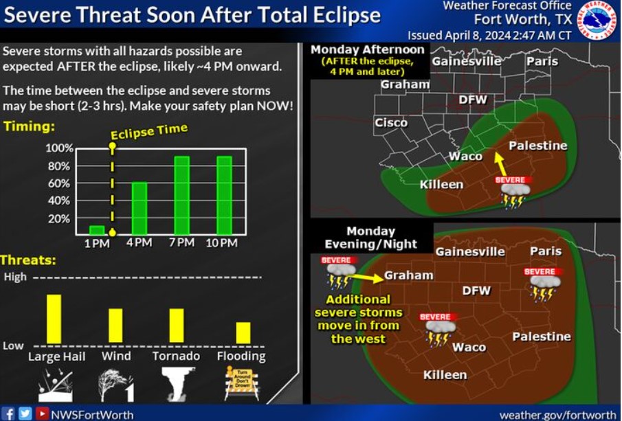
Severe thunderstorm chances return this afternoon after the eclipse. Some areas may only have two to three hours between the eclipse and strong to severe storms. Make your safety plan now and have multiple ways to receive warnings! The primary threat is large hail, but tornadoes, damaging winds, and flooding are all possible. The severe weather threat will continue overnight for much of the area.
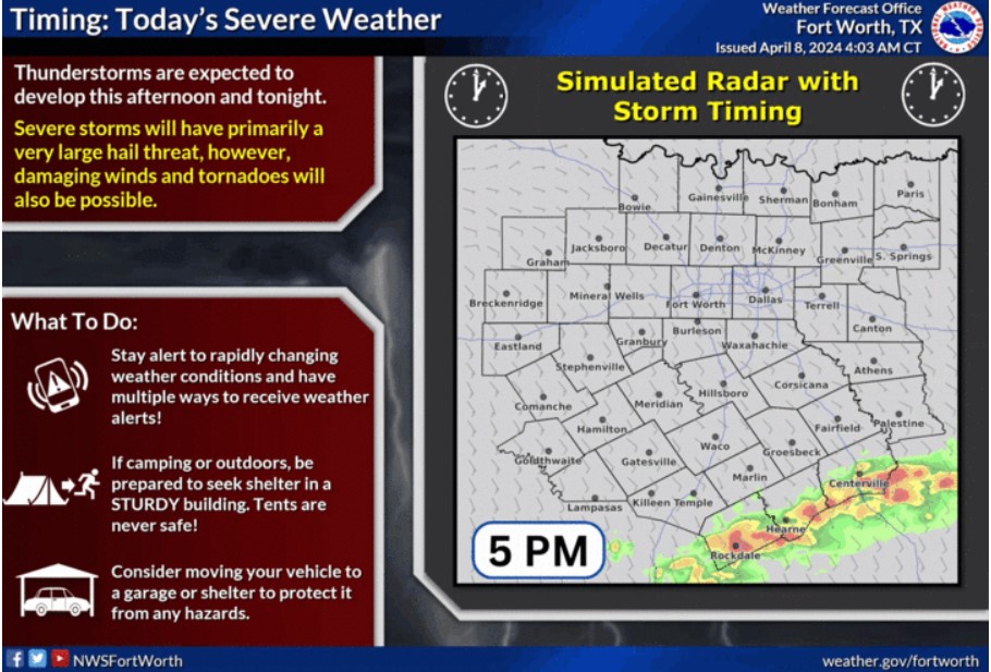
Here’s the latest information about storm timing for today and tonight. Severe storms primarily threaten with large hail, but damaging winds and tornadoes are also possible. Stay alert to rapidly changing conditions and have multiple ways to receive weather alerts. Be prepared to seek shelter in a sturdy building if camping or outdoors. Tents are never safe! Consider moving your vehicle to a garage or shelter to protect it from hazards.
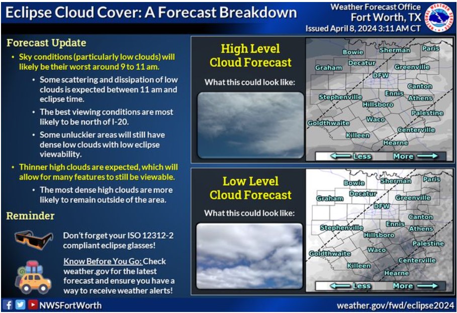
Sky conditions, shallow clouds, will likely be their worst around 9:00 to 11:00 am. Expect some scattering and dissipation of low clouds between 11:00 am and the eclipse time. The best viewing conditions are most likely to be north of I-20. Some unluckier areas will still have dense, low clouds with low eclipse viewability. Expect thinner, higher clouds, allowing many features to be viewable. The most dense high clouds are more likely to remain outside our area. Remember your eclipse glasses, and know before you go- Check weather.gov for the latest forecast, and ensure you can receive weather alerts!
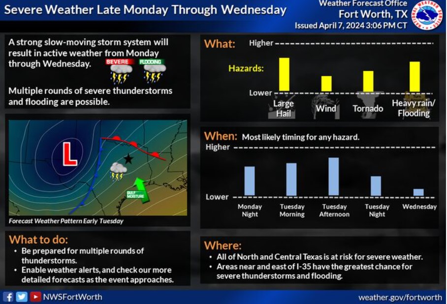
Expect showers and thunderstorms to develop late Monday afternoon and evening after the eclipse. Additional storms are expected late Tuesday into Wednesday. Some of these storms have the potential to become vital to severe, with all hazards possible, including flooding. Monitor the forecast and ensure you have multiple ways to receive weather alerts.
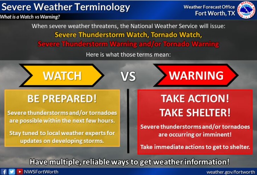
A watch means conditions are favorable for severe weather, which may occur within a few hours. A warning means it is ongoing or imminent; take shelter immediately!
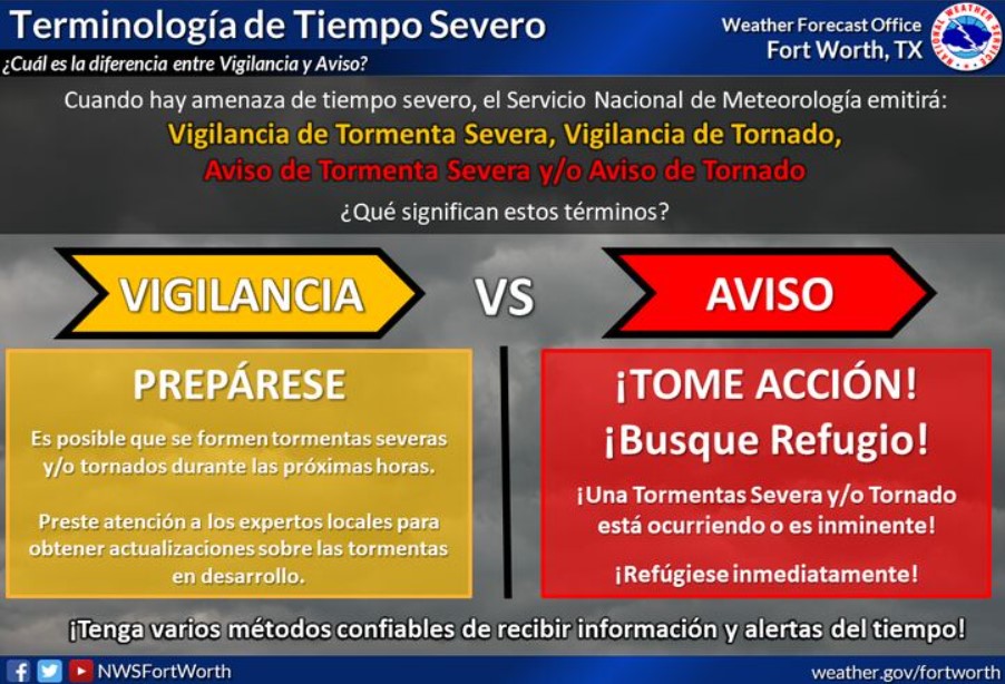
Vigilancia = Preparese. Es posible durante las proximas horas. Aviso = Tome Accion! Busque refugio! Esta occuriendo o es inminente.
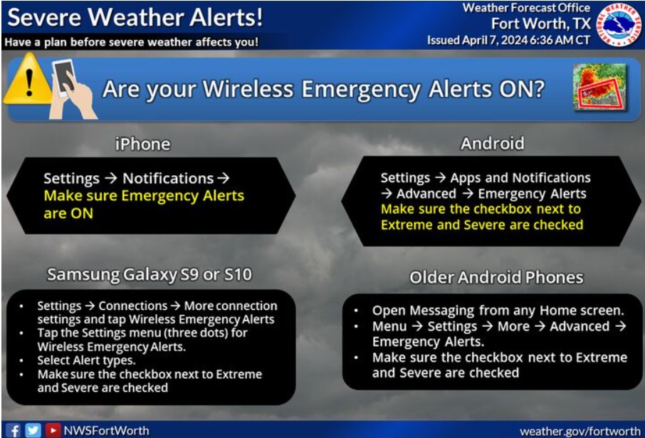
The NWS forecasted severe weather for late Monday afternoon after the eclipse into Wednesday. Now is the time to prepare, especially if you’re traveling! Know which office issues forecasts and warnings for where you are, and ensure you know where to shelter if a warning is issued for your location. Ensure you also have multiple ways to receive warnings, including enabling Wireless Emergency Alerts on your phone!
Excessive rainfall can cause flooding in North Central and Northeast Texas. It includes the following counties in North Central Texas: Freestone, Hunt, Kaufman, and Navarro, and in Northeast Texas: Anderson, Delta, Henderson, Hopkins, Lamar, Rains, and Van Zandt. Expect flooding this evening through Wednesday morning.
Excessive runoff may flood rivers, creeks, streams, and other low-lying and flood-prone locations. Creeks and streams may rise from their banks, and low-water crossings may flood. Rainfall totals of 2 to 4 inches, with isolated higher amounts up to 6 inches.
PRECAUTIONARY/PREPAREDNESS ACTIONS
You should monitor later forecasts and be alerted for possible flood warnings. If you live in areas prone to flooding, you should prepared to take action should flooding develop.
Today and Tonight
Thunderstorm chances increase this afternoon and evening. Expect severe storms with all possible hazards after 4:00 pm into the evening. The primary threat is large hail, but tornadoes, damaging winds, and flooding are all possible.
Tuesday through Sunday
The severe weather threat continues through Tuesday night. All hazards are possible with this activity. Flooding due to heavy rainfall will also be a threat through the midweek, primarily east of I-35.
SPOTTER INFORMATION STATEMENT
Spotter activation may be needed late this afternoon and evening.
South Central and Southwest Arkansas, North Central and Northwest Louisiana, Southeast Oklahoma, and East and Northeast Texas
Strong to severe thunderstorms and excessive heavy rainfall, possibly resulting in at least isolated flash flooding, will be possible late in the day Monday through Monday Night across portions of the Four State Region.
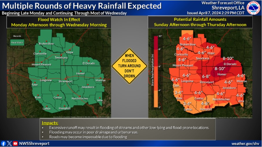
Expect multiple rounds of heavy rainfall from Monday afternoon through at least Wednesday morning. Widespread rainfall totals of 3 to 6 inches are expected, with scattered pockets of 6 to 8 inches. Isolated higher amounts are possible. It will likely result in a widespread threat of flooding. Therefore, a Flood Watch has been issued for the entire Four State Area from Monday afternoon through Wednesday morning.
Confidence in a widespread flooding event caused by excessive heavy rainfall, beginning late today and continuing through Wednesday, continues to increase.
It includes these counties in Arkansas, Columbia, Hempstead, Howard, Lafayette, Little River, Miller, Nevada, Sevier, and Union, Louisiana, including the following parishes: Bienville, Bossier, Caddo, Caldwell, Claiborne, De Soto, Grant, Jackson, La Salle, Lincoln, Natchitoches, Ouachita, Red River, Sabine, Union, Webster, and Winn, Southeast Oklahoma, McCurtain, and Texas, includes Angelina, Bowie, Camp, Cass, Cherokee, Franklin, Gregg, Harrison, Marion, Morris, Nacogdoches, Panola, Red River, Rusk, Sabine, San Augustine, Shelby, Smith, Titus, Upshur and Wood.
Today and tonight
Isolated to scattered showers and thunderstorms will be possible today and tonight, along and in advance of a cold front. Tonight, a marginal threat exists for strong to severe thunderstorms, mainly across Deep East Texas, into Northern Louisiana, and South Central Arkansas. Any strong to severe thunderstorms should remain very isolated.
Monday through Saturday
Showers and thunderstorms will become widespread late on Monday and
continue through at least Wednesday. Strong to severe thunderstorms will be possible Monday through Wednesday, with large hail, damaging thunderstorm wind gusts, and isolated tornadoes all possible as well. Excessive, heavy rainfall could result in a flash flood concern late Monday through at least early Wednesday. Rainfall amounts of 3 to 6 inches with isolated higher amounts will be possible Monday through early Wednesday as well with isolated higher amounts. Low-lying and flood-prone areas will be the most significant flood concern, with additional rises on all area waterways very probable.
SPOTTER INFORMATION STATEMENT
Do not expect spotter activation through tonight.