


North and Central Texas

Another round of isolated to scattered showers and thunderstorms is expected from mid-afternoon through midnight again today. Some storms will become severe, with large hail and damaging winds. Slow-moving storms and localized instances of heavy rainfall may lead to flash flooding. Timing for showers and storms is between 3:00 pm and 11:00 pm.
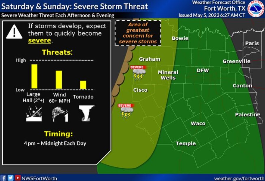
The threat of strong to severe storms continues this weekend along a dry line. If storms develop, expect showers to become powerful quickly, then shift east through the afternoon/evening. The greatest threat will be significant, huge hail, damaging winds, and a tornado. Make sure to remain weather aware!
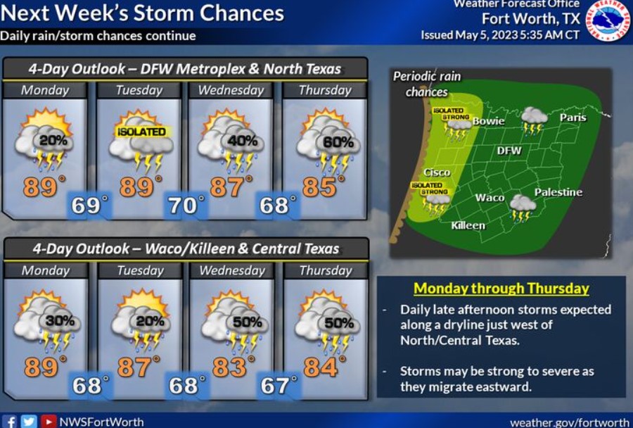
The weather pattern will continue into next week, with nearly daily opportunities for thunderstorms. A few strong to severe storms will be possible. Warm temperatures are expected daily, with highs in the mid to upper 80s.
Today and Tonight
Isolated to scattered strong to severe storms are possible again this afternoon, mainly along and west of the I-35 corridor. Large hail and damaging winds will be the main threats, although you can’t rule out a tornado or two.
Saturday through Thursday
Additional scattered thunderstorms are possible across most of the area Saturday through Thursday, particularly during the afternoon and evening hours each day. Some storms may become intense or severe during this period, with threats of hail and damaging winds.
SPOTTER INFORMATION STATEMENT
The NWS could request limited spotter activation along and west of I-35 this afternoon and evening.
South Central and Southwest Arkansas, North Central and Northwest Louisiana, Southeast Oklahoma, and East and Northeast Texas
Rain chances will remain across the region today, especially before Noon, as a disturbance moves across the region. You can’t rule out some gusty winds in some of the stronger storms. Expect a hot and humid day, with afternoon highs from the low 80s north to 90 degrees along and south of the Interstate 20 corridor.
Today and tonight.
A few clusters of showers and thunderstorms will continue to affect areas mainly along and north of Interstate 30 this morning. Don’t rule out a few intense storms capable of small hail and gusty winds through around midday. Otherwise, expect no hazardous weather through tonight.
Saturday through Thursday
Scattered showers and thunderstorms will continue this weekend and into next week. The overall threat of severe weather remains low, but don’t rule out the potential for isolated severe thunderstorms and locally heavy rainfall during this period. Damaging winds and large hail will be the primary threats to severe storms.
SPOTTER INFORMATION STATEMENT
Do not expect spotter activation at this time.