


North and Central Texas

One last round of showers and thunderstorms will move across the area today. While the threat of severe storms is low, a few intense storms capable of hail and gusty winds are possible, especially along and east of I-35. In addition, the threat of heavy rain and flooding will continue in parts of Central and East Texas. Rain will exit the area this evening while gusty northwest winds arrive behind a cold front.

A Flood Watch remains in effect for portions of Central and East Texas through 7:00 pm, where an additional 1-2 inches of rainfall with isolated totals as high as 3 inches is possible. Give yourself time for travel, and never drive through flooded roads!

A rain-free period will begin Thursday and prevail through the upcoming weekend. A warming trend will push temperatures back above average, with 80s across the entire region by Sunday. Clouds will also increase, but there will still be plenty of sunshine.
South Central and Southwest Arkansas, North Central and Northwest Louisiana, Southeast Oklahoma, and East and Northeast Texas
After a rain-free weekend, precipitation chances return early next week. The next storm system will approach from the west, bringing rain/storm chances through at least mid-week. Severe weather is possible, including the potential for heavy rain and some flooding. Continue to check back for forecast updates!
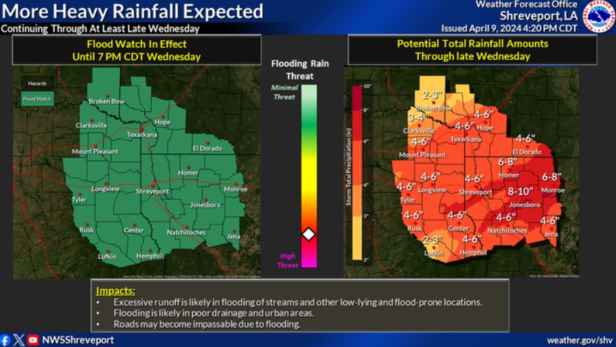
FLOOD WATCH NOW IN EFFECT THROUGH THIS EVENING
Flooding caused by excessive rainfall continues to be possible for portions of North Central and Northeast Texas, which include the following counties: Freestone, Hunt, Kaufman, Limestone, and Navarro in North Central Texas; Anderson, Delta, Henderson, Hopkins, Lamar, Rains, and Van Zandt in Northeast Texas. It is in effect through 7:00 pm.
Excessive runoff may flood rivers, creeks, streams, and other low-lying and flood-prone locations. Creeks and streams may rise out of their banks, and low-water crossings may become flooded. Expect additional rainfall totals of 1 to 2 inches, with isolated higher amounts near 3 inches.
PRECAUTIONARY/PREPAREDNESS ACTIONS
You should monitor later forecasts and be alert for possible Flood Warnings. If you live in areas prone to flooding, you should prepared to take action should flooding develop.
Expect multiple rounds of heavy rainfall on Wednesday. Widespread rainfall totals of 4 to 6 inches are expected, with scattered pockets of 6 to 8 inches. Isolated higher amounts are possible. It will likely result in a widespread threat of flooding. Therefore, a Flood Watch remains in effect for the entire Four State Area through Wednesday evening.
Today and Tonight
Scattered showers and thunderstorms remain in the forecast. That is for much of the daytime hours and into this evening before the rainfall exits our region to the north and east toward sunrise Thursday Morning. Once again, there will be a threat of locally heavy rain in some places, with additional amounts near one to two inches and isolated higher amounts possible.
Soils remain very saturated, and area waterways are full at this time and any additional rainfall will only exacerbate any ongoing flooding from previous rainfall across the Four State Region.
Likewise, there will be a severe weather threat today across mainly portions of Deep East Texas into portions of Northern Louisiana and South Central Arkansas: large: large hail and and damaging wind gusts. You can not rule out an isolated tornado threat through this afternoon. There could be some small hail-producing thunderstorms in association with the upper trough itself today into this evening, as well across the remainder of the Four-State Region.
A cold front will accompany the upper trough’s arrival later today through tonight, resulting in solid northwest winds sustained near 15 mph with gusts upwards of 30 mph possible.
Thursday through Tuesday
Do not anticipate any hazardous weather at this time.
SPOTTER INFORMATION STATEMENT
Spotter activation could become necessary later today.