


North and Central Texas
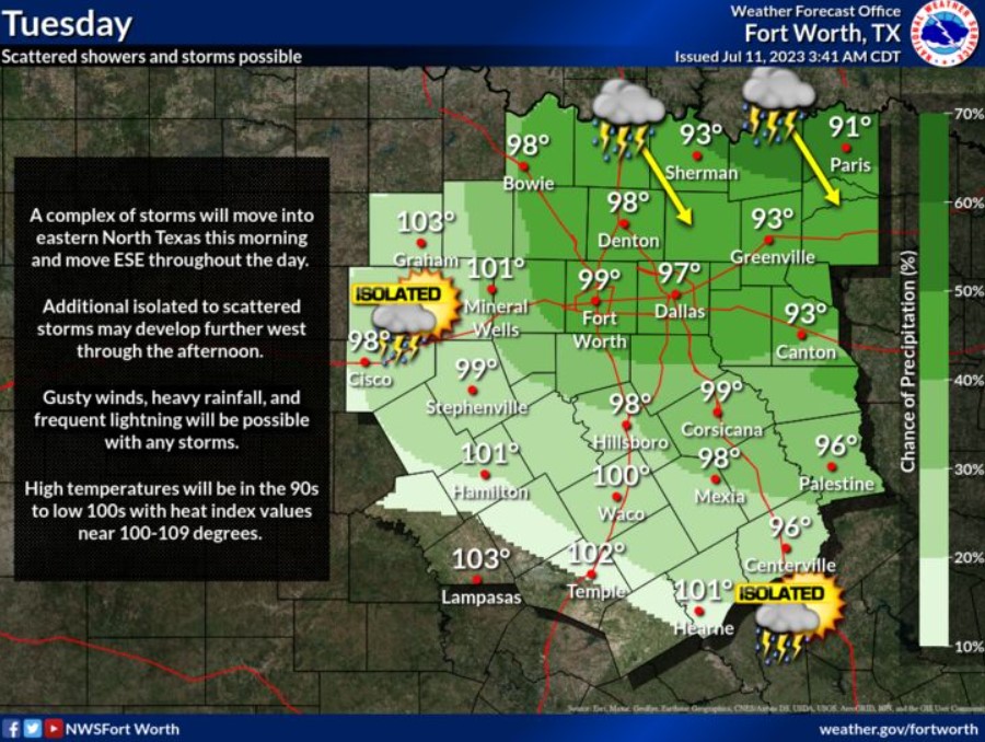
A complex of storms will move into eastern North Texas this morning and continue East Southeast throughout the day. Additional isolated to scattered thunderstorms may develop further west through the afternoon. Gusty winds, heavy rainfall, and frequent lightning will be possible with any developing storm. Otherwise, it’ll be a hot day across North and Central Texas, with highs in the 90s to low 100s and heat index values near 100-109 degrees.

A Heat Advisory is effective through 9:00 pm Wednesday as peak heat indices reach 105-112. Make sure to practice heat safety by drinking plenty of water, avoiding extended time outdoors, and knowing the signs of heat illness.
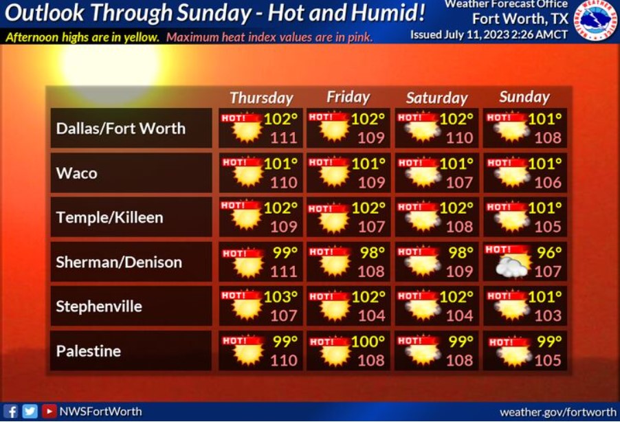
Hot and humid weather will continue late in the week through the weekend, with highs from the upper 90s to around 103 and afternoon heat index values as high as 111. No precipitation is expected Thursday through Sunday.
Today and Tonight
Scattered thunderstorms are expected across North Texas today. Frequent lightning and gusty winds will be the main hazards.
Heat index values will climb above 105 degrees for North and Central Texas this afternoon.
Wednesday through Monday
Hot and humid weather will continue early next week, with afternoon heat index values between 105 and 113 degrees across North and Central Texas.
SPOTTER INFORMATION STATEMENT
Do not expect spotter activation at this time.
South Central and Southwest Arkansas, North Central and Northwest Louisiana, Southeast Oklahoma, and East and Northeast Texas
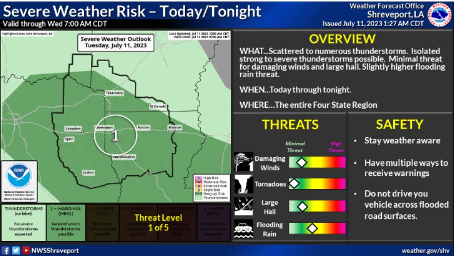
Scattered to numerous thunderstorms will impact portions of the Four-State Region today and again tonight. Do not expect widespread severe thunderstorms at this time, but an isolated severe thunderstorm, capable of producing damaging wind gusts and large hail, is possible. In addition, locally heavy rainfall will accompany these storms.
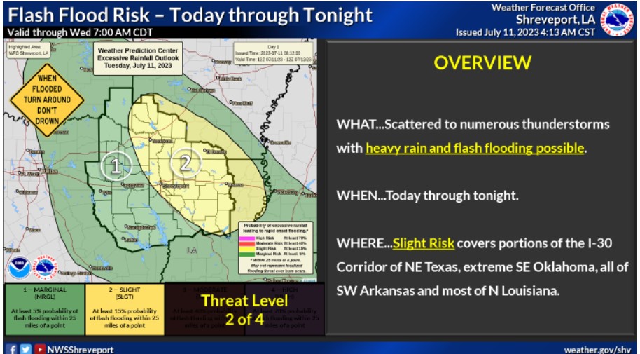
There will be a risk of flash flooding today through tonight across portions of far Southeast Oklahoma and Northeast Texas, as well as much of Southwest Arkansas and Northern and Northeast Louisiana. Storms will produce excessive heavy rainfall, which could result in localized flash flooding.
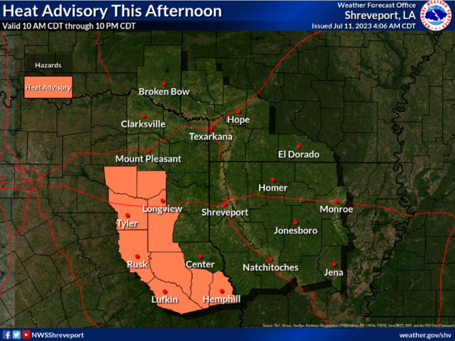
A Heat Advisory will go into effect across the southwest tier of the Four-State Region starting at 10:00 am and running through 10:00 pm today. Heat indices of 105 to 109 degrees will be possible in the area shaded in orange.
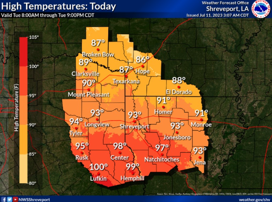
Highs today will range from the upper 80s across the north to near 100 across the southwest.
Today and Tonight
Look for scattered to numerous thunderstorms across the region once again today and possibly overnight as well. Some of these storms could produce strong wind gusts and hail. In addition, excessive, heavy rainfall could accompany the thunderstorms. Thus an isolated flash flood threat cannot be ruled out today through tonight.
Wednesday through Monday
The heat is here to stay across the region for the remainder of the work week. Look for the likelihood of Heat Advisories through at least the rest of the work week and into the weekend’s first half. Thunderstorms chances may return to the region Sunday into Monday of next week.
SPOTTER INFORMATION STATEMENT
Do not expect spotter activation at this time.