


North and Central Texas

Frigid temperatures and strong winds will allow dangerously cold wind chills as low as -15 degrees. These wind chills could result in hypothermia if you don’t take precautions. Make sure to avoid extended time outdoors if possible, and if you have to brave the cold, then dress in warm, lightweight layers and cover exposed skin. Bring pets and any sensitive outdoor plants indoors, if possible, and protect outdoor pipes and faucets.
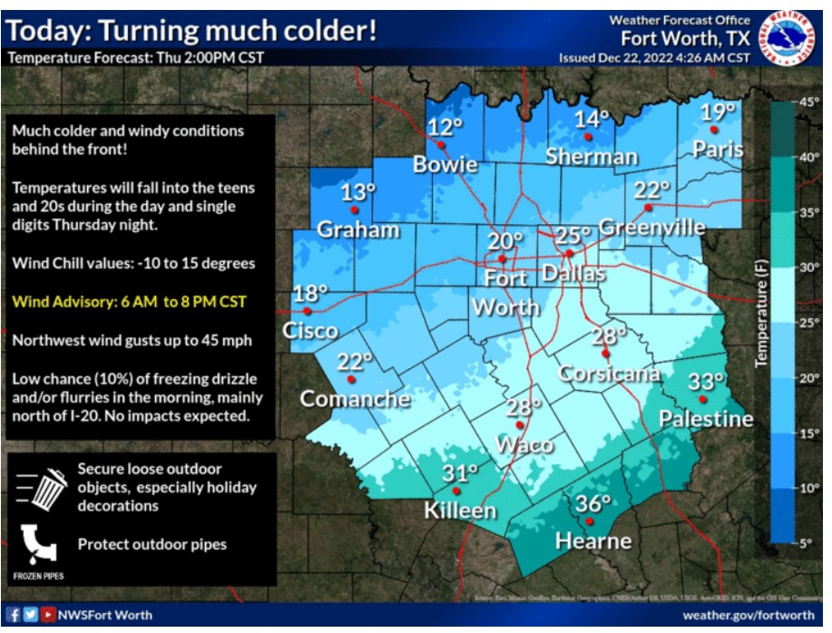
This morning, a strong cold front will blast through the region, leaving behind solid and gusty winds and sharply dropping temperatures. The freezing front should exit the area around noon. With these wind speeds, secure any outdoor items and Christmas decorations!
A prolonged period of subfreezing temperatures and dangerously cold wind chills will begin this afternoon and continue into the Christmas weekend. These temperatures will damage exposed outdoor pipes. So, follow the frigid weather precautions and limit time spent outdoors.

Expect continued cold temperatures on Saturday, with highs in the 30s. Many locations will stay below freezing. Christmas Day will start in the teens and 20s for lows and wind chills before warming up into the 40s and 50s for a mild Christmas Afternoon. Skies will be mostly clear, with winds around ten mph or less.
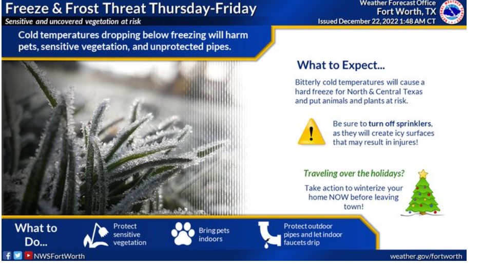
Cold temperatures dropping below freezing will harm pets, sensitive vegetation, and unprotected pipes. Be sure to turn off the sprinklers.
THE WIND ADVISORY REMAINS IN EFFECT FROM 6:00 THIS MORNING TO 8:00 THIS EVENING.
A HARD FREEZE WARNING REMAINS IN EFFECT FROM 6:00 THIS EVENING TO 9:00 FRIDAY MORNING.
* WHAT – For the Hard Freeze Warning, temperatures as low as 5
degrees expected. For the Wind Advisory, northwest winds of 20 to
30 mph with gusts up to 45 mph expected.
* WHERE – All of North and Central Texas.
* WHEN – For the Hard Freeze Warning, from 6:00 This evening to 9:00 Friday morning. For the Wind Advisory, from 6:00 am to 8:00 pm Thursday.
* IMPACTS – Wind will move unsecured outdoor items. Driving on area roadways may become difficult, especially for high-profile vehicles. Frost and freeze conditions will kill crops and other sensitive vegetation and possibly damage unprotected outdoor plumbing.
* ADDITIONAL DETAILS – Temperatures will fall into the single
digits and low teens Thursday night. Winds will rapidly
increase after 6:00 am Thursday, peaking from early to mid-afternoon Thursday before gradually abating Thursday evening.
PRECAUTIONARY/PREPAREDNESS ACTIONS
A Wind Advisory means that you should expect sustained winds of at least 20 to 30 mph. Winds this strong can make driving
difficult, especially for high-profile vehicles. Boaters should
use extra caution when venturing onto area lakes. Residents may
wish to take action to secure trash cans, lawn furniture, Christmas decorations, and other lightweight outdoor objects.
Take steps now to protect tender plants from the cold. To prevent
freezing and possible bursting of outdoor water pipes, they should
be wrapped, drained, or allowed to drip slowly. Those that have
in-ground sprinkler systems should drain them and cover above-
ground pipes to protect them from freezing.
THE WIND CHILL ADVISORY REMAINS IN EFFECT FROM 6:00 THURSDAY MOURNING UNTIL NOON FRIDAY.
* WHAT – Expect frigid wind chills as low as 15 below zero.
* WHERE – North Texas and portions of Central Texas.
* WHEN – From 6:00 Thursday morning until noon Friday.
* IMPACTS – The cold wind chills could result in hypothermia if you don’t take precautions.
* ADDITIONAL DETAILS – Wind chills will fall into the single
digits across North Texas Thursday morning. Expect Wind chills to fall below zero by Thursday afternoon.
PRECAUTIONARY/PREPAREDNESS ACTIONS
Use caution while traveling outside. Wear appropriate clothing, a
hat, and gloves.
THE WIND ADVISORY REMAINS IN EFFECT FROM 6:00 THIS MORNING TO 8:00 THIS EVENING.
A HARD FREEZE WARNING REMAINS IN EFFECT FROM 6:00 THIS EVENING TO 9:00 FRIDAY MORNING.
* WHAT – For the Hard Freeze Warning, temperatures as low as 5
degrees expected. For the Wind Advisory, expect northwest winds of 20 to 30 mph with gusts up to 45 mph expected.
* WHERE – All of North and Central Texas.
* WHEN – For the Hard Freeze Warning, from 6:00 this evening until 9:00 Friday morning. For the Wind Advisory, from 6:00 am until 8:00 pm Today.
* IMPACTS – Wind will blow unsecured outdoor items around. Driving on area roadways may become difficult, especially for high-profile vehicles. Frost and freeze conditions will kill crops and other sensitive vegetation and possibly damage unprotected outdoor plumbing.
* ADDITIONAL DETAILS – Temperatures will fall into the single
digits and low teens Thursday night. Winds will rapidly
increase after 6:00 am Thursday, peaking from early to mid-afternoon Thursday before gradually abating Thursday evening.
PRECAUTIONARY/PREPAREDNESS ACTIONS.
A Wind Advisory means that sustained winds of at least 20 to
30 mph. Winds this strong can make driving difficult, especially for high-profile vehicles. Boaters should use extra caution when venturing onto area lakes. Residents may wish to take action to secure trash cans, lawn furniture, and other lightweight outdoor objects that may blow around in the strong winds.
Take steps now to protect tender plants from the cold. To prevent freezing and possible bursting of outdoor water pipes, they should be wrapped, drained, or allowed to drip slowly. Those that have in-ground sprinkler systems should drain them and cover above-ground pipes to protect them from freezing.
Today and Tonight.
This morning, a strong cold front will move through the region, bringing bitterly cold temperatures and strong northerly winds. Wind gusts reaching 35 to 45 mph will be possible in the afternoon and evening before diminishing tonight.
Anticipate some very light snow, or more likely, flurries may occur briefly behind the front Thursday across Northeast Texas. Expect no travel impacts.
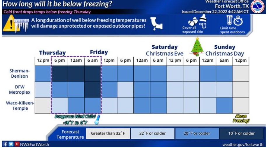
A hard freeze is expected Thursday night into Friday morning for nearly the entire region, which could result in damage to unprotected pipes and exterior faucets.
The winds and sub-freezing temperatures will result in wind chills from 5 to 15 degrees below zero across the entire region Thursday night into Friday morning.
Friday through Wednesday.
Sub-freezing temperatures will persist through at least Saturday morning for all areas, and again Saturday night into Christmas morning.
South Central and Southwest Arkansas, North Central and Northwest Louisiana, Southeast Oklahoma, and East and Northeast Texas

A Wind Chill Advisory is now in effect for the entire region from Thursday afternoon through Friday morning, causing wind chill values to drop near to below zero behind an Arctic cold front Thursday night through Friday morning. Gusty northwest winds combined with cold temperatures in the single digits or lower teens will produce dangerously cold wind chills.
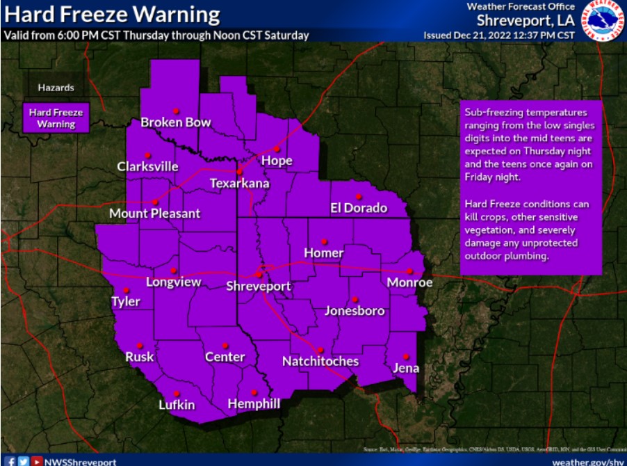
A Hard Freeze Warning is in effect from 6:00 pm Thursday through Noon Saturday. It is because it will be the coldest air of the season during this time frame, with bitterly cold temperatures and even colder wind chills.
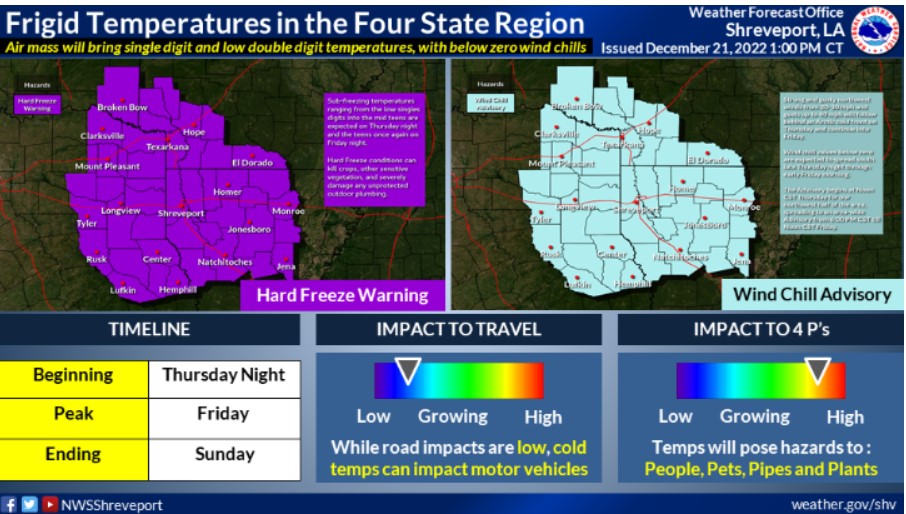
A strong blast of cold Arctic air will make its way to the Four State Region starting Thursday night and into the weekend. It is essential now to prepare to stay ahead of these frigid temperatures. Remember the four Ps: People, Plants, Pets, and Pipes.
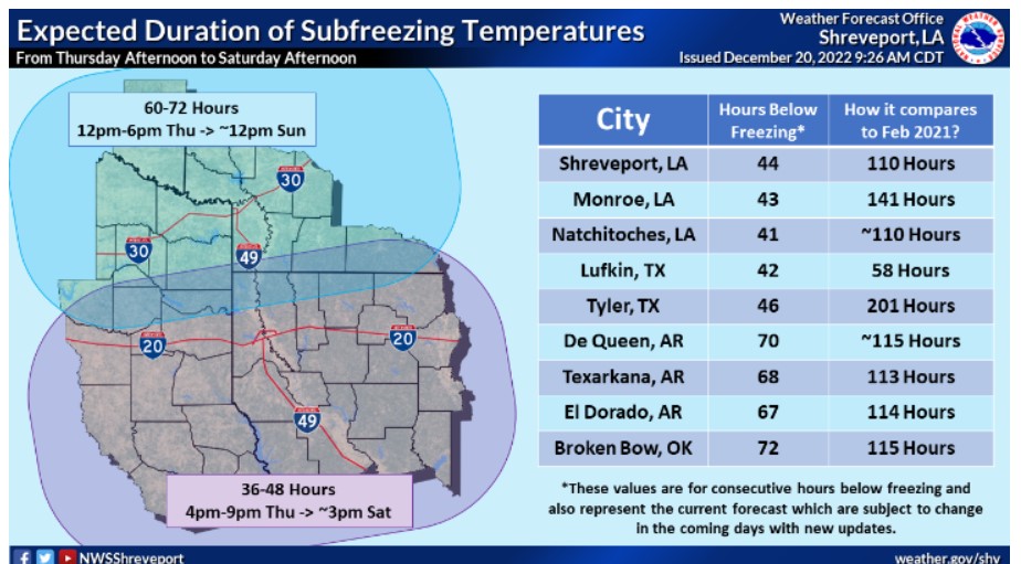
How long will the temperature remain below freezing across your location? First, pick your site on this map, which is the forecast duration of consecutive hours of freezing temperatures. Then, compare this duration to the last significant cold snap in February 2021.
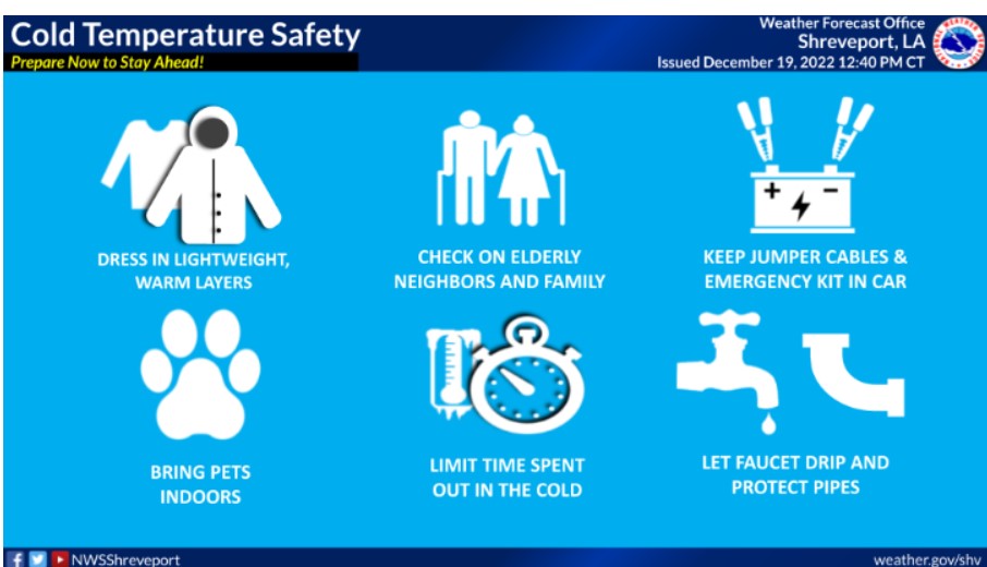
Now is the time to prepare for the cold weather. When frigid temperatures settle in, it is essential to make a plan for these things. Make sure you have layers to dress in, your pets are warm and brought inside, limit time spent in the cold, check on the elderly, and let faucets drip to protect pipes.
A WIND ADVISORY IS IN EFFECT FROM 10:00 THIS MORNING TO 6:00 am FRIDAY.
A HARD FREEZE WARNING REMAINS IN EFFECT FROM 6:00 pm THIS EVENING TO NOON SATURDAY.
* WHAT – Expect sub-freezing temperatures from the lower single digits to the lower teens for the Hard Freeze Warning. Expect northwest winds of 20 to 30 mph with gusts up to 40 mph for the Wind Advisory.
* WHERE – Portions of South Central and Southwest Arkansas, North Central and Northwest Louisiana, Southeast Oklahoma, and East and Northeast Texas.
* WHEN – For the Hard Freeze Warning, from 6:00 Thursday evening to noon CST Saturday. For the Wind Advisory, from 10:00 this
morning to 6:00 Friday morning.
* IMPACTS – Strong winds and rough waves on area lakes will create
hazardous boating conditions for small craft. In addition, frost and freeze conditions will kill crops and other sensitive vegetation and could severely damage unprotected outdoor plumbing.
PRECAUTIONARY/PREPAREDNESS ACTIONS
Boaters on area lakes should use extra caution since strong winds
and rough waves can overturn small craft.
Take steps now to protect tender plants from the cold. To prevent
freezing and possible bursting of outdoor water pipes, they should
be wrapped, drained, or allowed to drip slowly. Those that have
in-ground sprinkler systems should completely drain them and cover
above-ground lines to protect them from freezing.
THE WIND CHILL ADVISORY REMAINS IN EFFECT FROM NOON TODAY TO NOON FRIDAY.
* WHAT – Expect dangerously cold wind chills as low as 10 to 15 below zero.
* WHERE – Portions of Southwest Arkansas, Southeast Oklahoma, and Northeast Texas.
* WHEN – From noon Thursday to noon CST Friday.
* IMPACTS – Dangerously cold wind chills could result in frostbite
or hypothermia with prolonged exposure to frigid air if you don’t take precautions.
PRECAUTIONARY/PREPAREDNESS ACTIONS
Use caution while traveling outside. Wear appropriate clothing, a
hat, and gloves.
Today and tonight.
Freezing Arctic air will arrive this afternoon, with a slight chance of light rain and light wintry precipitation for portions of the region. However, expect no accumulations or impacts at this time. The primary concern will be the windy conditions and the duration of this frigid air mass. Temperatures tonight will fall into the single digits and lower teens. With winds gusting over 30 mph, wind chill values will fall below zero.
Friday through Wednesday.
Winds will diminish throughout the day on Friday, but temperatures
will remain below freezing all day, with lows Friday night falling
into the teens. Afternoon temperatures on Saturday will only climb
into the lower and mid-30s, with the entire area finally rising
above freezing by Christmas afternoon. This warming trend will continue next week, with near-normal temperatures returning by Wednesday.
SPOTTER INFORMATION STATEMENT
Activating spotters, HAM radio operators, and emergency management personnel could support the extreme cold conditions through Saturday.