


North and Central Texas

Friday through Sunday will be mostly sunny and hot in most locations, with highs generally in the 90s. Scattered storms are possible daily, with the best chances across the northeast Saturday and Sunday. Gusty winds and lightning are the main hazards of any storms that develop.

Hot weather is expected next week, with a few storms possible. Afternoon highs will reach the triple digits for most. Heat index values will be even higher, with some areas hitting or exceeding 110. Make sure to practice heat safety!
Today and Tonight
This afternoon, there is a slight chance of thunderstorms, generally east of the I-35 corridor. Gusty winds and lightning will be the primary hazards.
Saturday through Thursday
Low thunderstorm chances will continue Saturday through Tuesday across mainly the northern and eastern parts of the region. Any storm that develops will have the potential to produce lightning, gusty winds, and heavy rain.
Heat index values above 105 degrees will return this weekend and into the middle of next for much of the area, posing an increased threat for heat-related illnesses.
SPOTTER INFORMATION STATEMENT
Do not expect spotter activation at this time.
South Central and Southwest Arkansas, North Central and Northwest Louisiana, Southeast Oklahoma, and East and Northeast Texas

There’s a risk for severe thunderstorms from Saturday afternoon into the evening hours across portions of Southeast Oklahoma and Southern Arkansas. Damaging winds and large hail will be the primary threats.
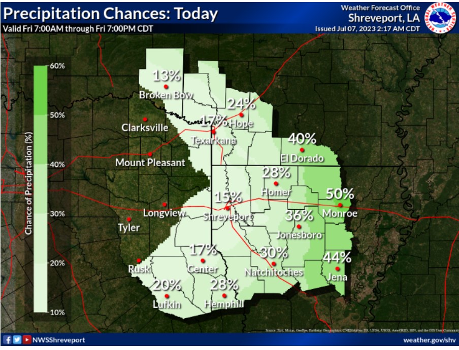
Scattered showers and thunderstorms are possible across much of North Louisiana and South Arkansas today, especially this afternoon.
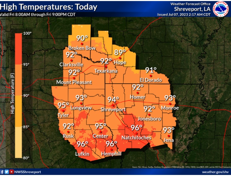
Warm and muggy conditions continue. Daytime high temperatures will range from the upper 80s to mid-90s.
Today and Tonight
Isolated showers and thunderstorms will be possible across parts of the area today. For severe weather, a Marginal Risk, Level 1/5, remains in place for our extreme northern zones. Gusty winds will accompany stronger storms.
Saturday through Thursday
The next organized severe weather threat will develop on Saturday, with areas along and north of the I-30 corridor included in a Marginal Risk, Level 1/5, and our extreme northern zones in a Slight Risk, Level 2/5. Damaging winds and hail are the primary associated hazards with these storms, as well as brief periods of
heavy rainfall. Thunderstorm chances continue on a near-daily basis through the course of the coming week, with the best opportunities for stronger storms being across the northern and eastern zones of the central weather area, into Southwest Arkansas and parts of North & Central Louisiana.
Temperatures are on track to climb back into the mid to upper 90s late this weekend and into next week.
SPOTTER INFORMATION STATEMENT
Do not expect spotter activation at this time.