


North and Central Texas

Expect scattered severe thunderstorms late this afternoon and evening. This threat will be greatest near and North of I-20, but isolated severe storms could develop anywhere in North and Central Texas. Initial storms in western North Texas late this afternoon could be capable of enormous hail and have slightly increased potential for tornadoes. Large hail and damaging winds will be the main threats.
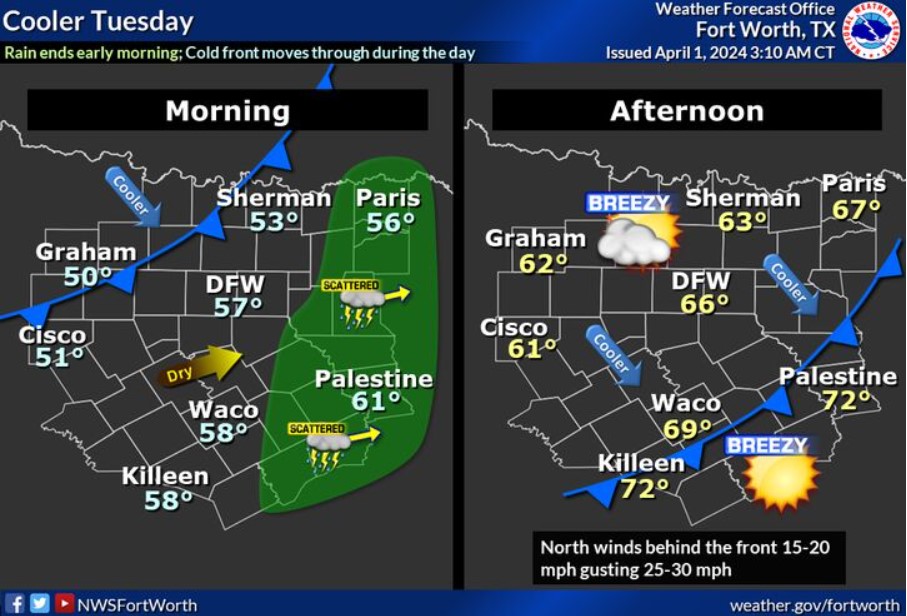
Storms will continue eastward Tuesday morning, ending entirely by daybreak. A cold front will move through Tuesday morning and afternoon, bringing cooler temperatures and breezy north winds.

Storm chances will end Monday night, followed by a dry and seasonable remainder of the work week.

Here’s an early look at the eclipse sky outlook, trending cloudier than usual. A typical April 8 has a 45 percent chance of favorable viewing conditions, while the current outlook for this April 8 has a 15 percent chance for favorable viewing conditions. Confidence is increasing that a weather pattern may bring moisture and cloud cover with a chance of rain around the eclipse day. The eclipse is still eight days out, and the forecast is still uncertain, so be sure to check our daily updates!

We know many people have travel plans for the April 8 eclipse, so here are some travel tips and advice to ensure you’re prepared! Also, check the latest forecast before you go, and ensure you have a way to receive weather alerts.
Today and Tonight
Expect scattered thunderstorms across parts of North and Central Texas this afternoon and evening. Some storms could become severe, threatening large hail and damaging winds. This activity will also have a low tornado threat, mainly north of I-20 and west of I-35, through the early evening.
Tuesday through Sunday
Thunderstorm chances will return Saturday night and Sunday.
SPOTTER INFORMATION STATEMENT
The National Weather Service could request spotter activation this afternoon and evening, primarily north of the I-20 corridor.
South Central and Southwest Arkansas, North Central and Northwest Louisiana, Southeast Oklahoma, and East and Northeast Texas

On Monday evening, portions of the Four-State Region remain at risk for strong to severe storms. Be sure to check the forecast for changes and updates.
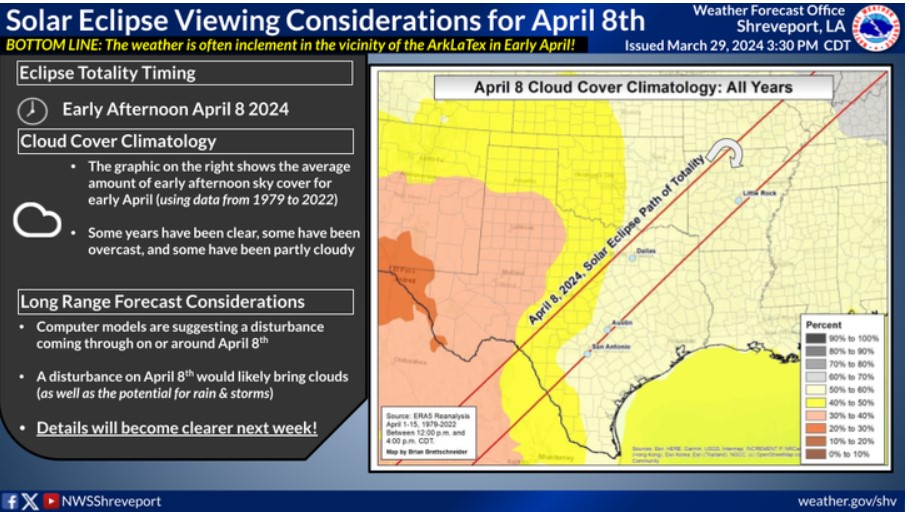
This image provides information on cloud cover climatology from April 8, 1979, to 2022. On average, about 50-60 percent of the sky is obscured by clouds on April 8. This may limit viewing potential, especially with the potential for a storm system to be in the vicinity. However, forecast details will be refined beginning early next week.
Today and Tonight
Severe weather chances return to the region by this evening, lingering into the overnight hours. Large hail and damaging winds will be the main threat, with most of this activity occurring past 11:00 pm. An isolated tornado also can’t be ruled out.
Tuesday through Sunday
Do not expect any hazardous weather at this time.
SPOTTER INFORMATION STATEMENT
Spotter activation may be needed.