


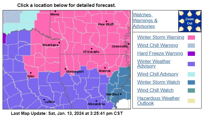
Winter Storm Warning in effect from Sunday noon until Monday at 6:00 pm
MONDAY
Expect heavy mixed precipitation with total sleet and snow accumulations of up to two inches and ice accumulations between one-tenth to a quarter of an inch. It includes portions of South Central Arkansas, North Central and Northwest Louisiana, and Northeast Texas. Plan on slippery road conditions with hazardous conditions impacting the morning or evening commute.
PRECAUTIONARY/PREPAREDNESS ACTIONS
If you must travel, keep an extra flashlight, food, and water in your vehicle in case of an emergency. You can obtain the latest road conditions for the state you call from by calling 5 1 1.
North and Central Texas
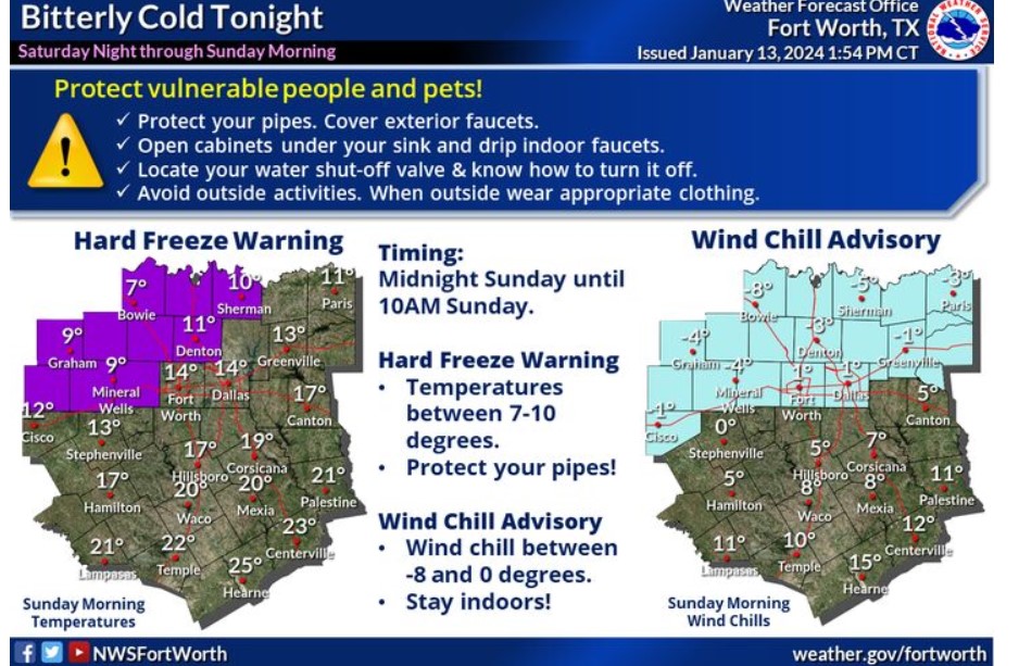
Temperatures will fall below freezing for North and Central Texas tonight and Sunday morning. Some locations across western North Texas will fall into the single digits. Most places along and north of I-20 will experience wind chills at or below zero from midnight through 10:00 am Sunday. Protect vulnerable people and plants from the cold! Protect your pipes and avoid outdoor activities.
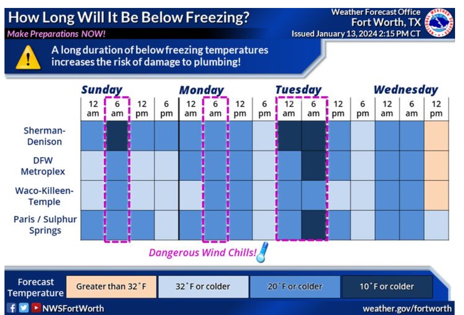
An arctic blast arrives tonight, with dangerously cold temperatures late this weekend through mid-next week. Temperatures will remain below freezing from tonight through Wednesday morning for nearly all of North and Central Texas. Now is the time to complete freeze preparations. Make sure to protect exposed and vulnerable pipes by covering or wrapping them. During the cold weather, drip any indoor sinks. Now is an excellent time to locate your water shut-off valve if you have to turn off the water to your residence or business. Remember to protect and check on people and pets during the cold, too!
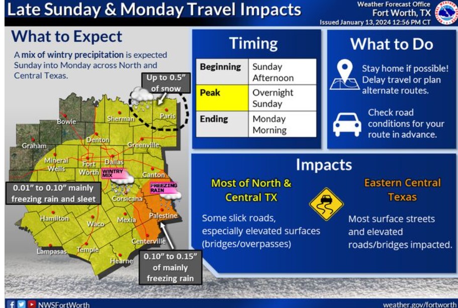
A mix of wintry precipitation is expected across North and Central Texas beginning Sunday afternoon and ending during the morning hours on Monday. Most regions will likely see between 0.01 and 0.10 inches of mainly freezing rain and sleet. Higher ice accumulations in Eastern Central Texas may impact most surface streets and elevated roads/bridges. There is a chance for snow, up to 0.50 inches, in far Northeastern counties, including Paris.
Here’s the latest thinking for timing and precipitation types from Sunday afternoon through Monday. Expect freezing drizzle to develop Sunday afternoon across the region. A transition to a wintry mix is expected Sunday evening through the overnight hours. Coverage of frozen precipitation will peak late Sunday night through Monday morning, with the highest chances anticipated East of I-35, near 40- 60%, and lower chances West of I-35, 20-40%. A complete transition to snow is likely along the Red River. Additionally, freezing rain may remain the dominant precipitation type across Central Texas for much of the night. Most precipitation will end by midday Monday, but isolated sleet or snow areas may linger across eastern North and Central Texas into early Monday afternoon.
Today and Tonight
Frigid temperatures will arrive this evening. Wind chills will fall below zero at times tonight across portions of North Texas, with temperatures falling into the single digits in some areas.
Now is the time to ensure you protect your home against the cold. Protect any outdoor pipes and let indoor faucets drip during the prolonged sub-freezing temperatures.
Sunday through Friday
Frigid temperatures will continue through Wednesday morning. Wind chill values will sometimes fall below zero, with low temperatures in the teens and single digits Sunday night through Wednesday morning.
A wintry mix is expected Sunday afternoon through midday Monday.
While accumulations will be light, expect impacts on untreated roads. Ice may accumulate on trees and power lines and cause isolated outages, but the chance of this is low.
SPOTTER INFORMATION STATEMENT
Do not expect spotter activation at this time.
South Central and Southwest Arkansas, North Central and Northwest Louisiana, Southeast Oklahoma, and East and Northeast Texas
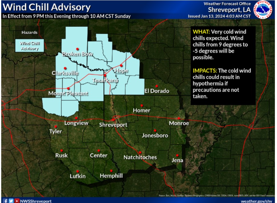
The weekend will see-saw from warmer to colder with the threat of mixed winter precipitation by late Sunday. Snow, sleet, and freezing rain will all be possible. Stay tuned to the forecast for the latest over the next few days. A Wind Chill Advisory will go into effect at 9:00 pm Saturday and continue through 10:00 am Sunday. Expect wind chill values from 9 degrees to -5 degrees. Use precaution if you must be outdoors.
This afternoon and tonight.
The Arctic frontal boundary will arrive late Saturday afternoon in Southeast Oklahoma spread into Texas and Arkansas this evening with no precipitation overnight. Dangerous single-digit wind chills will be possible before the onset of any winter precipitation.
Sunday through Friday
Please listen to NOAA Weather Radio or go to weather.gov on the Internet for more information about the Wind Chill Advisory and the Winter Storm Warning.
A significant and impactful winter precipitation event will begin Sunday afternoon and continue into early next week. Expect bitterly cold temperatures through at least Wednesday morning, with overnight lows in the single digits and low teens on Monday and Tuesday nights keep us below-freezing until midweek. The wintry
mix of precipitation will begin Sunday afternoon with light freezing rain and sleet that will quickly transition to snowfall. Ice and snow accumulations of 2 to 4 inches will make travel difficult, with some 6-inch amounts possible. Prepare this weekend for this holiday weekend winter event and gather adequate supplies during extended power outages.
SPOTTER INFORMATION STATEMENT
Do not expect spotter activation at this time.