


North and Central Texas
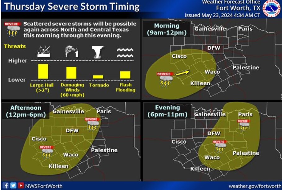 Scattered severe storms will be possible again across much of North and Central Texas starting late this morning through this evening. Many locations will miss out on the storms, but the locations that do experience storms could see large hail, damaging wind gusts, and perhaps an isolated tornado. Localized heavy rainfall may reinvigorate flooding. Make sure to have multiple ways to receive warnings today!
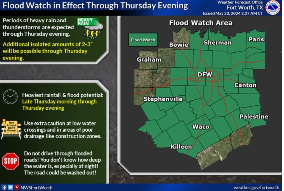
A Flood Watch remains in effect for much of North and Central Texas through Thursday evening. Additional isolated amounts of 2-3″ inches will be possible. However, most locations will see much less than that amount. If you encounter flooded roadways, Turn Around, Don’t Drown!
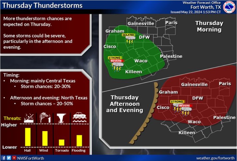
An upper-level disturbance will create a chance of storms on Thursday. Storm chances will be highest across Central Texas in the morning, then North Texas in the afternoon. Some storms may be severe, particularly for areas along and north of I-20.
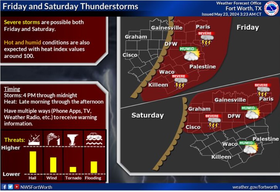
Be prepared: more thunderstorm chances are on the horizon. On Friday, storms are expected along and east of I-35, and on Saturday, they will move along and north of I-20. Some of these storms could be severe, bringing with them large hail, damaging winds, heavy rain, and the possibility of a tornado or two. Additionally, the weather will be hot and humid, with heat indices around 100 each afternoon.
Today and Tonight
There is a chance of storms today and tonight, with the best storm chances across North Texas. A few of the storms may be severe and also contain heavy rain.
Friday through Wednesday
There are additional chances for thunderstorms on Friday and Saturday. Though storm coverage may be isolated, developing storms could quickly become severe. Additional storms are possible around the middle of next week.
SPOTTER INFORMATION STATEMENT
Expect limited spotter activation requests this afternoon and evening.
South Central and Southwest Arkansas, North Central and Northwest Louisiana, Southeast Oklahoma, and East and Northeast Texas
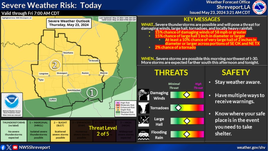
More severe storms are possible across the entire area today and tonight. Damaging winds, large hail, tornadoes, and locally heavy rainfall are possible.
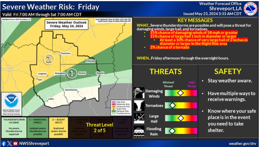
Scattered strong to severe thunderstorms will be possible Friday afternoon and into Friday night, mainly north of a line from Rusk, TX, to Monroe, LA. Damaging winds, large hail, and tornadoes are possible.
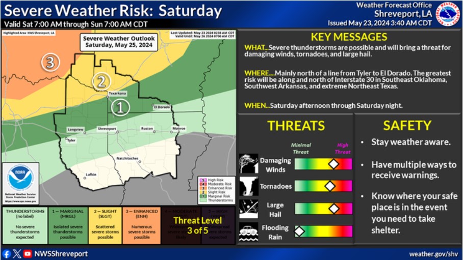
Another round of strong to severe storms will be possible Saturday afternoon through Saturday night north of a line from Tyler to El Dorado. The most significant risk will be along and north of Interstate 30. Damaging winds, tornadoes, and large hail will be possible.
Today and Tonight
Strong to severe thunderstorms will be possible again today, into the evening and overnight hours across much of the Four-State Region. Large hail, damaging thunderstorm wind gusts, and locally heavy downpours will be the primary threats, with an isolated tornado threat as well. The severe weather threat should end from northwest to southeast across the Four-State Region overnight tonight. While widespread flooding is not likely through tonight, flooding of low-lying and flood-prone areas will be possible with heavy downpours through tonight.
Friday through Wednesday
Severe weather will be possible once again late Friday into Friday Night and late Saturday into Saturday Night across mainly portions of Northeast Texas, Southeast Oklahoma, and Southwest Arkansas. Large hail and damaging thunderstorm wind gusts will again be the main threats on Friday and Saturday.
A strong cold front will move through the region on Memorial Day and Monday Night, bringing another chance of thunderstorms. Before the cold front arrives late on Monday, we will see some of the hottest temperatures of the late Spring Season, with afternoon high temperatures on both Saturday and Sunday in the lower to middle 90s. Combine this with high afternoon humidity and heat indices, which could approach 105 degrees across some locations.
SPOTTER INFORMATION STATEMENT
Spotter activation will be possible later today through this evening.