


North and Central Texas
Scattered to numerous showers and thunderstorms will begin developing and continue through Saturday night. There will likely be periods of light rain or breaks in the rain, but confidence is low in where or when these will occur. A few strong to marginally severe storms are possible early Saturday. Hail and strong winds will be the main threats. Additionally, locally heavy rainfall may lead to flooding, mainly on Saturday afternoon and evening.
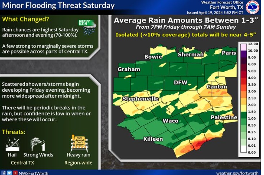
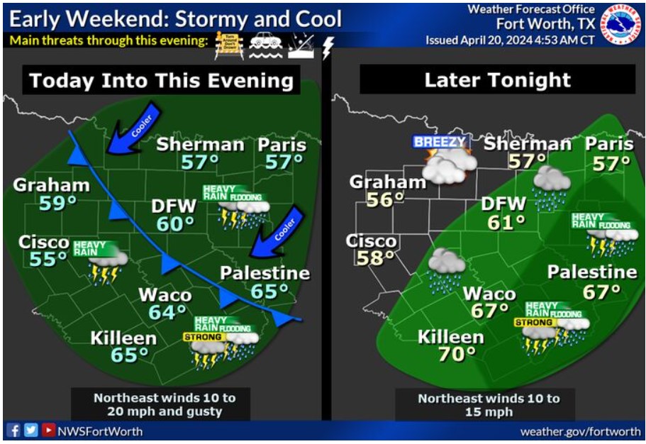 A stationary front will remain south of the area, with North and Central Texas on the cool side. Showers and scattered storms will increase and overspread the region this morning and into the afternoon. A few strong to marginally severe storms will be possible, mainly across Central Texas. Expect hail and heavy rainfall through tonight. Moderate to heavy rain with amounts between 1 to 3 inches is possible with widespread minor flooding. Heaviest amounts will occur across eastern Central Texas, where isolated instances of flash flooding will be possible later today and tonight. Another cool front will combine with the stormy conditions to limit highs to the 60s, below average for mid-April.
 Expect a cool Monday morning followed by a warming trend for the rest of next week. Rain chances will return late Tuesday and will continue through next weekend.
Today and Tonight
There is a chance of storms through tonight across much of the region. A few storms may be intense, with hail and frequent lightning. Heavy rain may also cause minor flooding locally.
Sunday through Friday
Thunderstorm chances return to the region Tuesday night and continue through the end of next week.
SPOTTER INFORMATION STATEMENT
Do not expect spotter activation at this time.
South Central and Southwest Arkansas, North Central and Northwest Louisiana, Southeast Oklahoma, and East and Northeast Texas
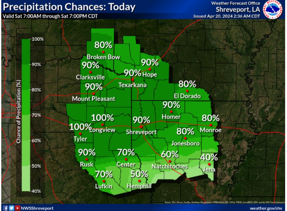
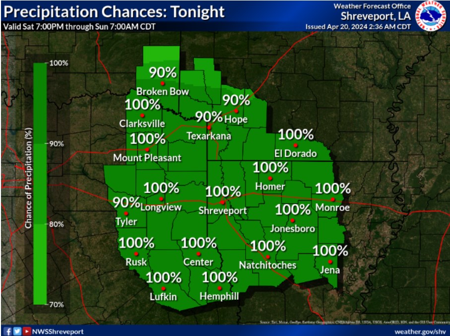
 Look for widespread rainfall of one to three inches, with isolated higher amounts possible through Sunday. This may result in additional rises on area waterways and localized flooding of flood-prone and poor drainage areas.
 Cooler temperatures are expected across the region today following a cold front combined with increasing showers and thunderstorms. Highs will range from the mid-and upper 50s north to the 60s and lower 70s south.
 Rain will expand across much of the region today as periods of showers, and expect a few embedded thunderstorms.
 Widespread showers and embedded thunderstorms will further expand across the area later tonight as a strong upper-level disturbance tracks into the region.
Hydrologic Outlook
National Weather Service Shreveport LA
2:42 pm Fri Apr 19. 2024
This weekend, expect heavy rainfall across portions of the Four-State Region.
An upper-level disturbance will result in periods of showers and embedded thunderstorms across the region. This rainfall will only become more widespread on Saturday and Saturday night. Look for widespread rainfall amounts of nearly one to three inches, with isolated higher amounts possible. The rainfall should quickly exit the Four-State Region from west to east during the day on Sunday.
While rainfall rates will likely not be excessive enough to result in widespread flash flooding, poor drainage and flood-prone areas will be susceptible to flooding. The more significant impacts will likely come from swollen bayous lakes and rivers that remain high from previous rainfall.
This forecast rainfall will likely slow down recent falling trends or cause additional rises on most area waterways that will continue into next week.