


North and Central Texas
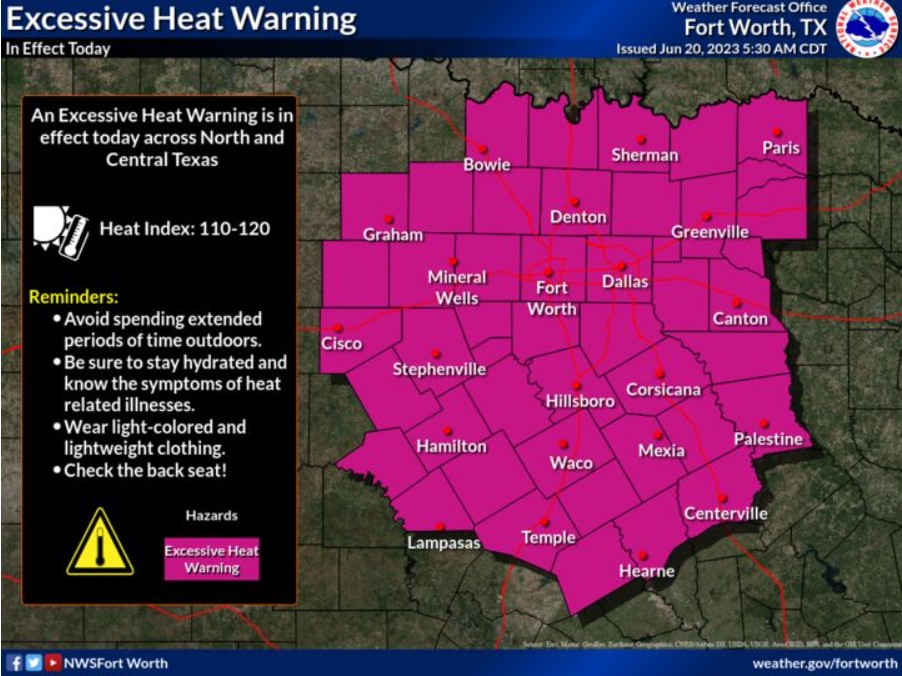
An Excessive Heat Warning is in effect until 8:00 pm Tuesday with heat index values of 110-120 degrees. This heat is dangerous, and you should use precautions. Drink plenty of water, avoid extended time outdoors, and know the signs of heat-related illness!
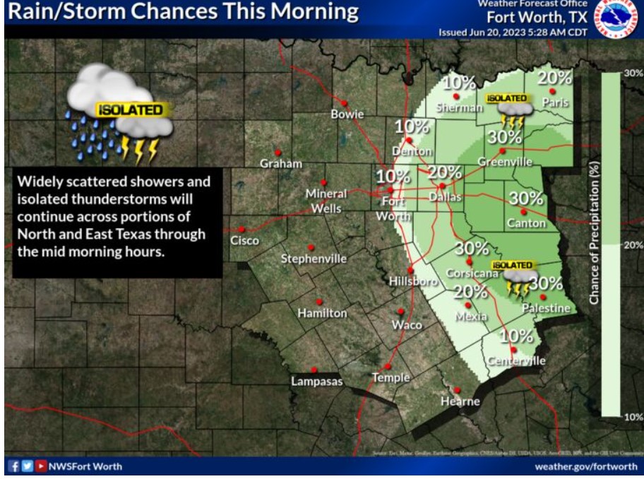
Widely scattered showers and isolated thunderstorms will be possible through the mid-morning hours across North and East Texas.
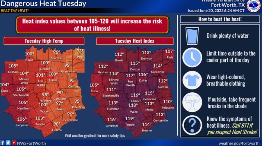
Tuesday will be hot, with highs in the 90s to 100s. Heat index values will be well above 100. Take precautions to BEAT THE HEAT! Drink plenty of water, limit time outside to the cooler part of the day, wear light-colored clothing, and take frequent breaks in the shade. Last but not least, know the symptoms of heat illness and Call 911 if you suspect heat stroke! It could save your or someone else’s life!
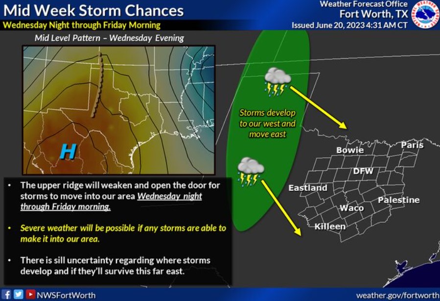
The upper ridge will weaken and open the door for clusters of storms to move in from the northwest. There is still uncertainty regarding how far east the thunderstorms will continue. If thunderstorms can move into our area, severe weather will be possible.
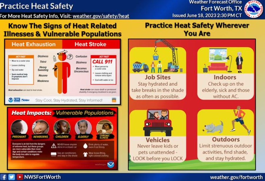
With this persisting heat, practice heat safety wherever you are! Know the signs of heat illness, and check on the more vulnerable populations. Drink plenty of water, avoid extended time outdoors during the day’s heat, and look before you lock!
Today and Tonight
Isolated to scattered thunderstorms are possible early this mainly across East Texas. Large hail would be the main threat to this activity.
Oppressive heat and humidity will increase the threat of heat-related illnesses if you do not take precautions. Make sure to drink plenty of water, wear light-colored clothing, and take frequent breaks if spending time outdoors.
Wednesday through Monday
Oppressive heat and humidity will continue through Wednesday.
A cluster of storms may move into the region Wednesday and Thursday nights. Some of these storms may be severe.
SPOTTER INFORMATION STATEMENT
Do not expect spotter activation at this time.
South Central and Southwest Arkansas, North Central and Northwest Louisiana, Southeast Oklahoma, and East and Northeast Texas
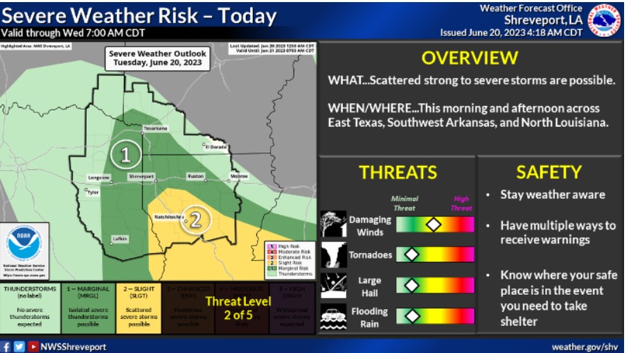
Scattered strong to severe thunderstorms will be possible this morning and afternoon across portions of East Texas, Southwest Arkansas, and North Louisiana near a stationary front. The primary threats will be damaging winds, hail, and an isolated tornado.
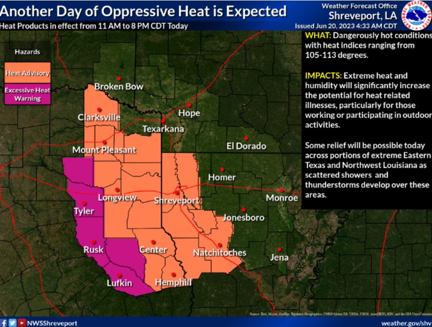
Temperatures this afternoon will again climb into the mid to upper 90s across East Texas and Western Louisiana, and when combined with the high humidity, will result in heat indices ranging from 105-110 degrees across the Heat Advisory area and 111-113 degrees across the Excessive Heat Warning area. These heat products are in effect until 8 pm this evening.
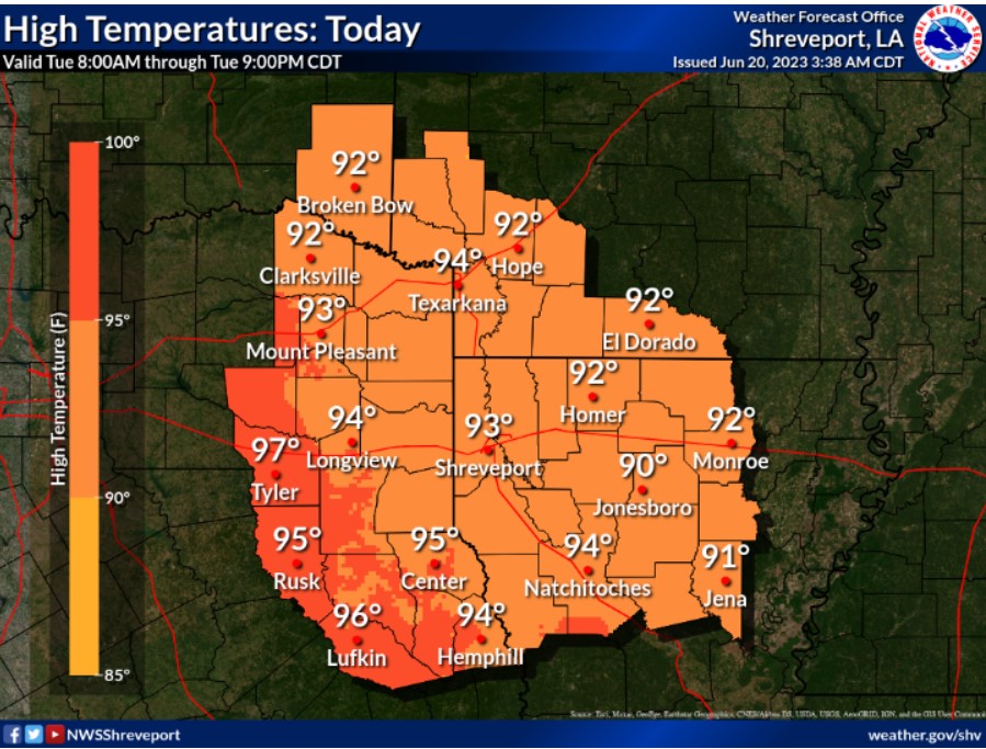
Slightly cooler temperatures are expected today, with increased cloud cover and the threat of isolated scattered showers and thunderstorms near a stalled frontal boundary. Look for high temperatures to range from the lower to mid-90s across the region.
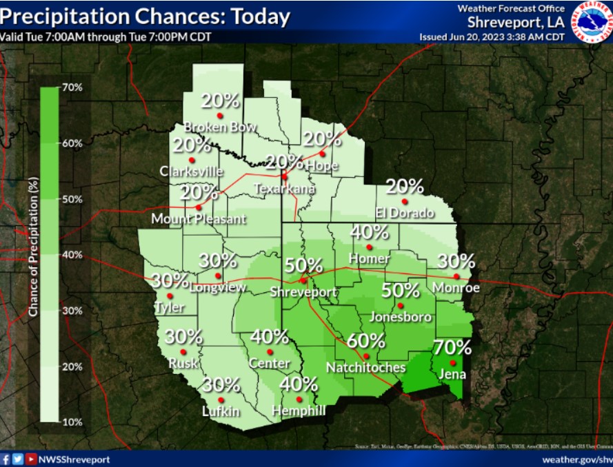
Isolated to scattered showers and thunderstorms will increase later this morning and afternoon across portions of East Texas and especially North Louisiana along a stationary frontal boundary. Some of these storms may be strong or severe, with damaging winds, hail, and an isolated tornado possible.
Today and Tonight
Increasing clouds and a chance for thunderstorms as an upper low moves down along our frontal boundary from southeast Oklahoma into the heart of the area. We do have a Marginal Risk in east Texas and Slight Risk south of I-20 in Louisiana for a severe thunderstorm with damaging winds. You can not rule out some hail and an isolated tornado during peak heating. Rain ends tonight with an arriving weak cold front that will shift the wind to Northeasterly.
Please listen to NOAA Weather Radio or go to weather.gov on the Internet for more information about today’s Heat Advisory.
Wednesday through Monday
Slight chances for a thunderstorm always seem to linger in the summer heat, but coverage will be sparse. We will see average temperatures to end the work week, but the weekend will see building high pressure aloft push the mercury into the mid to upper 90s. Use caution, as the heat will be more than what has been here lately. Expect no other hazardous weather at this time.
SPOTTER INFORMATION STATEMENT
Spotter activation may be needed.