North and Central Texas
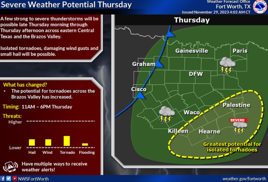
Rain chances return to the region late Wednesday night into Thursday. There is potential for a few strong to severe thunderstorms across portions of Eastern Central Texas and the Brazos Valley late Thursday morning through Thursday afternoon. Isolated tornadoes, hail, and damaging wind gusts will be possible in the yellow-circled area. Precipitation will exit to the east late Thursday evening as a cold front begins pushing into North Texas. Continue to follow the forecast over the next few days, and ensure you have ways to receive weather alerts if you are in the area of concern!

Increasing cloud cover is expected today, with afternoon highs in the low to mid-60s, near-normal for this time of year. Chances for rain showers, possibly a few thunderstorms, return to the region later tonight into Thursday morning, primarily along/east of I-35. More widespread showers and thunderstorms are expected by midday Thursday, with the potential for a few strong to severe thunderstorms late Thursday morning into Thursday afternoon across portions of eastern Central Texas and the Brazos Valley.
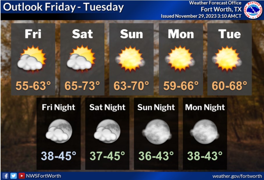
The weekend through early next week will be dry and seasonably cool, with highs mainly in the 60s and lows from the upper 30s to the mid-40s. A few locations will warm into the lower 70s on Saturday and Sunday.
Today and Tonight
Thunderstorms are possible late tonight, with the best chances east of the I-35 corridor. Lightning will be the primary hazard.
Thursday through Tuesday
Scattered to numerous thunderstorms are expected across North and Central Texas Thursday and Thursday evening, with the highest chances east of I-35. A few strong to severe thunderstorms capable of producing damaging wind gusts, isolated tornadoes, hail, and locally heavy rainfall will be possible late Thursday morning through Thursday afternoon, especially across eastern Central Texas and the Brazos Valley.
SPOTTER INFORMATION STATEMENT
Do not expect spotter activation at this time.
South Central and Southwest Arkansas, North Central and Northwest Louisiana, Southeast Oklahoma, and East and Northeast Texas
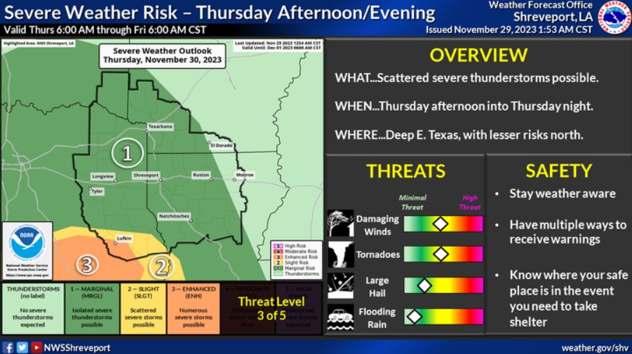
The risk of a few severe storms will return to southern parts of the region Thursday as a strong upper-level disturbance advances eastward across Texas. Any severe storms will likely be in lower East Texas, across Toledo Bend country, and into the adjacent areas of Northwest/Central Louisiana. However, a northward shift with the warm front is possible.
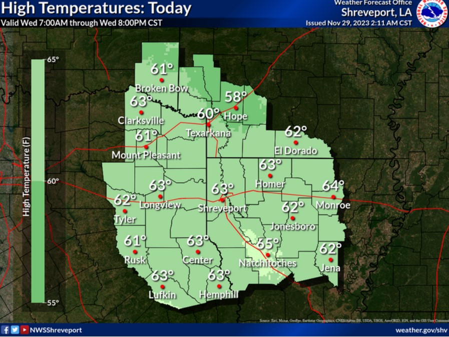
Skies will quickly see increasing clouds after daybreak, with low to mid-60s expected for the afternoon high temp.
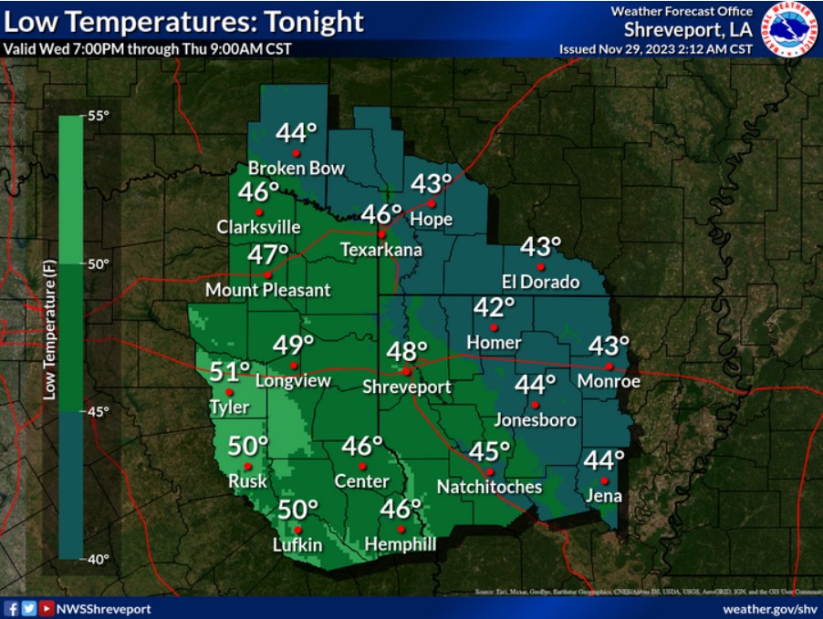
Lows tonight will begin to warm as winds shift back to the S/SW. Expect an increase in cloud cover. Overnight lows will generally range in the 40s.
Today and tonight
Do not anticipate any hazardous weather at this time.
Thursday through Tuesday
Expect the next storm system to move into the region Thursday into Friday morning. There will be periods of moderate to heavy rainfall during this period, but widespread flooding does not appear likely at this time. There is also a marginal severe weather risk, with hail being the primary threat.
SPOTTER INFORMATION STATEMENT
Do not expect spotter activation at this time.




 EastTexasRadio.com Powered by Ten Stations


