


North and Central Texas

A Severe Thunderstorm Watch is now in effect for parts of Central and North Texas until 11:00 am. Large hail will be the main threat, although damaging winds will also be possible. The tornado threat is low, but lines of storms can many times produce embedded tornadoes.

Showers and thunderstorms will continue to spread across the region this morning, mainly south of the I-20 corridor. A few storms may become vital to severe. The highest threat for all modes of severe weather will be across Central Texas. Have multiple ways to receive warnings!

A storm system passing through today will bring a medium chance of 40 to 50% of at least a trace of snowfall in the pink areas. An even lower chance of less than 20% exists for accumulations up to half an inch. Do not expect impacts except for grassy and elevated surfaces. Roads will be passable!

How can snow accumulate on grass and not on roads? Warm concrete temperatures will quickly melt any snowfall. Grassy surfaces will typically have cooler temperatures than concrete. Therefore, snow will melt at a much slower rate.

After an active weekend, dry and pleasant weather conditions will persist through the upcoming week. A slight warming trend is expected, with highs in the 60s to low 70s by Thursday. Our next round of precipitation will arrive Friday and last into the following weekend.
Today and Tonight
Thunderstorms will continue to move across North and Central Texas early this morning. Expect a few severe storms with large hail and strong wind gusts, with the most significant severe threat south of I-20. Heavy rain may produce minor urban and river flooding for areas east of I-35 and south of I-20. Thunderstorm chances will end from west to east by late Sunday morning.
Snow is possible across western North Texas Sunday night into Monday morning. Do not expect any travel impacts.
Monday through Saturday
Do not expect hazardous weather at this time.
SPOTTER INFORMATION STATEMENT
Expect limited spotter activation early this morning across Central Texas.
South Central and Southwest Arkansas, North Central and Northwest Louisiana, Southeast Oklahoma, and East and Northeast Texas

A Severe Thunderstorm Watch is in effect for much of the southern half of Northeast Texas until 11:00 am. While large hail will be the main threat with these storms, you can not rule out strong wind gusts and an isolated tornado.
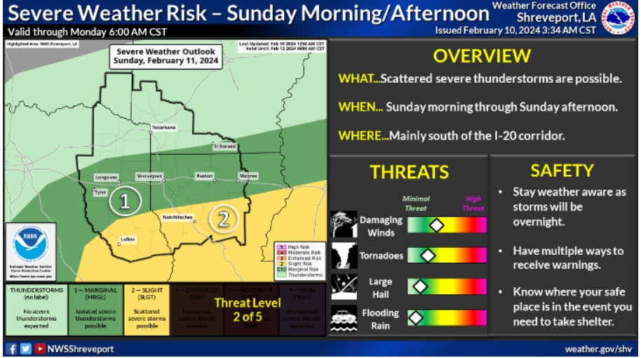
A Slight Risk for severe thunderstorms is highlighted over the southern half of our region from this morning through this evening, with a Marginal Risk along the I-20 corridor. The threat is mainly for storms containing damaging wind and possibly large hail. You can not rule out a tornado or two.
Today and tonight
Showers with embedded thunderstorms will increase across the region this morning, and some of these could pose a hail threat. Otherwise, the activity will move out of the region by late this afternoon but will return to the northern half of Northeast Texas, Southeast Oklahoma and Southwest Arkansas later this evening and into the
overnight hours as an upper-level storm system moves overhead. Any intense storms this evening could also result in a minor hail threat.
Monday through Saturday
The rain moves out early Monday Morning with drier conditions through at least Thursday. More unsettled weather returns to the region Friday and into next weekend in the form of more showers and thunderstorms.
SPOTTER INFORMATION STATEMENT
Spotter activation should not be needed.