


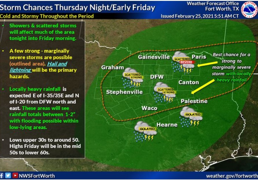
The forecast expects a cool, wet, and stormy Thursday night and Friday morning across North-Central Texas. A few storms may become briefly vital to severe, with hail and lightning being the primary hazards.
Additionally, heavy rainfall may occur east of I-35 and north of I-20, where localized totals between 1-2″ are possible. These amounts may result in minor flooding of low-lying areas overnight and early Friday morning, so plan accordingly. Overnight lows will be in the upper 30s to around 50, with highs Friday ranging from the mid-50s to the lower 60s.
South-Central and Southwest Arkansas, North-Central and Northwest Louisiana, Southeast Oklahoma, East Texas, and Northeast Texas.
Today and Tonight
Wood County has flood warnings around rivers.
Showers and thunderstorms will develop this evening and spread eastward overnight, bringing a marginal threat for a few isolated
severe storms for areas mainly along and north of I-20. The
primary threats with any strong to severe storms will be large
hail and damaging winds.
Friday through Wednesday
After a brief break, widespread showers and thunderstorms will
overspread the region again Saturday night into Sunday and
continue through Tuesday. Although specific details are still
unclear at this time, heavy rainfall and perhaps even an isolated
a threat for severe storms may be possible during this timeframe.
SPOTTER INFORMATION STATEMENT
The National Weather Service will not need the activation of emergency management personnel, amateur radio operators, and storm spotters through tonight.