


North and Central Texas
Today and Tonight
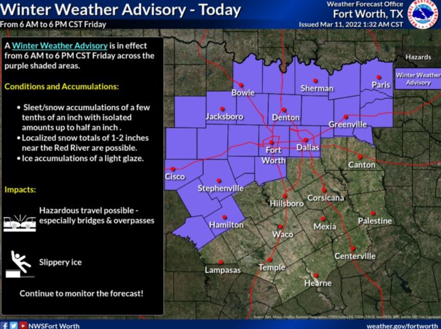
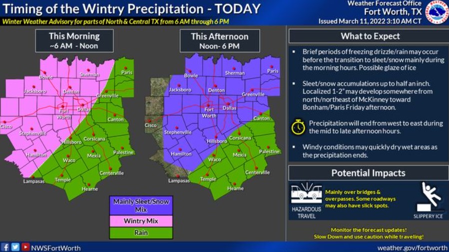
Expect wintry precipitation across a large portion of North Texas and western parts of Central Texas today. Rain will transition briefly to freezing rain in some areas during the morning before transitioning to sleet and snow expected by afternoon.
While the forecast does not indicate significant ice accumulations, a light glaze on bridges and overpasses will cause some travel impacts across the Winter Weather Advisory area today. Wintry precipitation should end from west to east by this evening.
In addition, strong north winds will gust to between 35 and 40 mph at times across North and Central Texas on Friday.
Friday through Wednesday
Low thunderstorm chances return to areas east of I-35/35E late Monday, as another cold front moves through the region without any severe.
SPOTTER INFORMATION STATEMENT
The NWS does not expect the activation of spotters at this time. However, reports of winter precipitation to the National Weather Service are appreciated.


South Central and Southwest Arkansas, North Central and Northwest Louisiana, Southeast Oklahoma, and Northeast Texas
Today and Tonight
Areas of rain will quickly increase across the region by mid to late morning, ahead of an upper-level disturbance and associated cold front. The cold front will move into the area this morning through the afternoon, with temperatures expected to fall to near freezing by mid to late this afternoon across portions of extreme Northeast Texas, Southeast Oklahoma, and Southwest Arkansas.
Expect the rain to change over to a wintry mix of sleet and snow across these areas as temperatures fall to near or below freezing late in the afternoon, before transitioning quickly to all snow during the evening. Snowfall accumulations near an inch or more will be possible mainly along and north of the I-30 corridor, especially on elevated surfaces such as bridges and overpasses, as well as on grassy surfaces. This wintry mix will eventually move into portions of extreme Southern Arkansas and Northern Louisiana later this evening, with very light snow accumulations possible before the precipitation diminishes ultimately around midnight.
Saturday through Thursday
Showers and isolated thunderstorms will be possible again Monday afternoon and night as a strong upper-level disturbance moves through the region. Some intense isolated storms can not be ruled out, with hail being the main threat from these stronger storms that develop. These storms will diminish from west to east Monday night.
SPOTTER INFORMATION STATEMENT
Activation of emergency management personnel, amateur radio operators and storm spotters could be activated through tonight with snowfall accumulations possible across the northern half of the region.